
Pricing Change
New pricing for orders of material from this site will come into place shortly. Charges for supply of digital images, digitisation on demand, prints and licensing will be altered.
Green Burn


Enclosure(S) (Period Unassigned), Lazy Beds (Post Medieval)
Site Name Green Burn
Classification Enclosure(S) (Period Unassigned), Lazy Beds (Post Medieval)
Canmore ID 162990
Site Number NY48NE 166
NGR NY 4585 8647
Datum OSGB36 - NGR
Permalink http://canmore.org.uk/site/162990


- Council Scottish Borders, The
- Parish Castleton
- Former Region Borders
- Former District Roxburgh
- Former County Roxburghshire
NY48NE 166 4585 8647
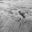
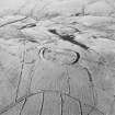
At the southern end of The Tongue, a spur between the Green Burn and an unnamed tributary, there is a palimpsest of earthen-banked enclosures and lazy-beds. The earliest feature is an oval enclosure, measuring about 48m from NNE to SSW by 42m, the interior of which is covered with lazy-beds. A rectangular enclosure, measuring about 9m by 7m, is butted onto this enclosure. The S half of the oval enclosure is overlain by an L-shaped length of bank forming an enclosure set against the E bank of the Green Burn. This later enclosure also contains lazy-beds, which have two different alignments. A further length of bank overlain by these lazy-beds may have been part of the earlier enclosure. The character and inter-relationships of these features is particularly well recorded on a RAF vertical aerial photograph (543/RAF/1507, F22, frame no.0204, 3 November 1961).
Visited by RCAHMS (DCC) 18 April 1999

