
Pricing Change
New pricing for orders of material from this site will come into place shortly. Charges for supply of digital images, digitisation on demand, prints and licensing will be altered.
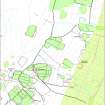
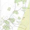
Kirk Hill


Enclosure (Post Medieval)
Site Name Kirk Hill
Classification Enclosure (Post Medieval)
Alternative Name(s) Park Hill
Canmore ID 162978
Site Number NY48NE 161
NGR NY 4646 8660
Datum OSGB36 - NGR
Permalink http://canmore.org.uk/site/162978


- Council Scottish Borders, The
- Parish Castleton
- Former Region Borders
- Former District Roxburgh
- Former County Roxburghshire
Field Visit (17 April 1996)
NY48NE 161 4646 8660
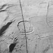
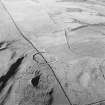
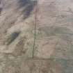
A trapezoidal turf-banked enclosure, probably for stock, is situated on the NE side of Kirk Hill; it measures about 160m from NE to SW by about 100m transversely. Vertical aerial photography (543/RAF/1507 F22: frame no.0204, 3 November 1961) reveals turf stripping across the northern half of the enclosure, and also a network of field-drains cutting the enclosure bank.
Visited by RCAHMS (DCC) 17 April 1996

