Hazelyside Hill
Building (Post Medieval), Cairnfield (Period Unknown), Field Boundary (Period Unknown), Kiln (Post Medieval), Quarry (Period Unknown), Rig And Furrow (Medieval) - (Post Medieval), Sheepfold (19th Century), Shieling Hut(S) (Medieval) - (Post Medieval)
Site Name Hazelyside Hill
Classification Building (Post Medieval), Cairnfield (Period Unknown), Field Boundary (Period Unknown), Kiln (Post Medieval), Quarry (Period Unknown), Rig And Furrow (Medieval) - (Post Medieval), Sheepfold (19th Century), Shieling Hut(S) (Medieval) - (Post Medieval)
Canmore ID 162971
Site Number NY48NE 154
NGR NY 4562 8808
NGR Description Centred on NY 4562 8808
Datum OSGB36 - NGR
Permalink http://canmore.org.uk/site/162971
- Council Scottish Borders, The
- Parish Castleton
- Former Region Borders
- Former District Roxburgh
- Former County Roxburghshire
Field Visit (15 February 1996 - 16 April 1996)
NY48NE 154 centred on 4562 8808
At the southern end of a broad terrace that runs along the foot of the E flank of Hazelyside Hill there are at least eight shieling-huts, a building, a kiln, a sheepfold, and a sand and gravel quarry. The E side of the terrace is bounded by boggy ground while to the W a bank runs along the face of Hazelyside Hill and may have enclosed some rig and at least one small cairn visible on the terrace.
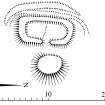
The shieling-huts are disposed in a loose group, five lying towards the leading edge of the terrace on the E, and a scatter of three, together with the building and the kiln, at the rear. Four of the huts of the easternmost group (NY 4565 8808, LID96 127-31) are subrectangular on plan and measure between 5.2m by 2.5m (LID96 129) and 7.6m by 2.4m (LID96 131) within grass-grown turf and stone footings. The fifth (LID96 128) is much smaller, measuring 4.4m by 2.9m overall. All are aligned from N to S and, their entrances, where visible, are in the E side (LID96 127, 129, 131). Grass-grown midden-heaps lie beside three (LID96 127, 129, 130) and drains to deflect surface water extend along the W side of two (LID96 127, 131).
Of the huts to the rear of the terrace (NY 4549 8809), the largest (LID96 295, NY 4548 8806) measures 8.6m by 3.4m internally; another (LID96 132, NY 4556 8791) has been reduced to a platform, measuring 7.5m by 4.8m overall and bounded by an fragmentary bank, and the third (LID96 294, NY 4559 8798) measures 4.2m by 2.4m with faced-rubble footings. The building (LID96 126) is substantially larger than any of the huts and measures 12.1m from NE to SW by 4m within a stony bank. The NE half of the interior is slightly sunken and there may be a byre drain along the centre. The bowl of the kiln (LID96 296, NY 4554 8814) has been dug into the terrace surface and measures 2.8m in diameter within a stony bank spread to 1.2m in thickness; the flue extends for about 2m to the SSE.
The terrace to the N of the buildings bears traces of rig (NY 4546 8830) that is characterised by shallow furrows about 4m apart and lies within the area bounded on the W by the bank along the face of Hazelyside Hill (from NY 4532 8817 to 4535 8853) and on the E by boggy ground. A short length of bank (from NY 4544 8806 to 4538 8807) lying at right-angles to the S end of this bank may be part of the same enclosure. A small cairn situated on the terrace, and measuring 3m in diameter (NY 4550 8820), may be the product of field clearance.
The sheepfold (LID96 116, NY 4568 8797) lies towards the leading edge of the terrace and comprises a circular enclosure with three subrectangular pens butted against it. The 1st edition of the OS 6-inch map (Roxburghshire 1862-3, sheet xlv) depicts the circular fold and one of the ancillary enclosures.
The sand and gravel quarry lies at the back of the terrace and has largely removed a glacial knoll; it comprises a large hollow (NY 4552 8796) with two smaller depressions immediately to the W.
(LID96 116, 126-32, 294-6)
Visited by RCAHMS (DCC) 15 and 27 February and 16 April 1996
Measured Survey (3 March 1998)
RCAHMS surveyed the shieling at Hazelyside Hill with plane-table and alidade on 3 March 1998 at a scale of 1:100. The resultant plan was redrawn in ink and published at a scale of 1:200.


