
Charlie's Sike


Quarry(S) (Period Unknown), Settlement (Later Prehistoric)
Site Name Charlie's Sike
Classification Quarry(S) (Period Unknown), Settlement (Later Prehistoric)
Canmore ID 162930
Site Number NY48NE 147
NGR NY 4744 8775
Datum OSGB36 - NGR
Permalink http://canmore.org.uk/site/162930


- Council Scottish Borders, The
- Parish Castleton
- Former Region Borders
- Former District Roxburgh
- Former County Roxburghshire
Field Visit (29 April 1996)
NY48NE 147 4744 8775
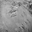
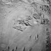
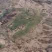
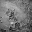
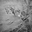
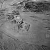
A settlement (LID96 368) is situated on a terrace to the S of Charlie's Sike, in a patch of rough ground in Newcastleton's golf course. Rectilinear on plan, it measures 61m from E to W by 49m transversely within a robbed stony bank spread to 3.5m in thickness and 0.4m in height. A natural break of slope runs across the interior of the settlement from NE to SW, dividing the flat E half from the more broken ground on the W. The entrance is on the E, opening into the flat half of the interior, which may have been a yard. Traces of the footings of a stone round-house measuring, about 9m in diameter, can be seen in the SE corner of the interior. In the western half of the interior there are the fragmentary footings of three further round houses, measuring 9m, 7m and 6.2m in internal diameter respectively and with their interiors dug into the slope.
The bank at the NE corner of the settlement has been removed by a stone quarry, one of three (NY 4748 8776, NY 4749 8780, NY 4752 8781) depicted in the vicinity on the 1st edition of the OS 6-inch map (Roxburghshire 1862-3, sheet xlv); they are not labelled on the map and were perhaps out of use by that date.
(LID96 368)
Visited by RCAHMS (DCC) 29 April 1996

