
Ettleton


Settlement (Later Prehistoric)
Site Name Ettleton
Classification Settlement (Later Prehistoric)
Canmore ID 162927
Site Number NY48NE 146
NGR NY 4738 8653
Datum OSGB36 - NGR
Permalink http://canmore.org.uk/site/162927


- Council Scottish Borders, The
- Parish Castleton
- Former Region Borders
- Former District Roxburgh
- Former County Roxburghshire
Field Visit (17 April 1996)
NY48NE 146 4738 8653
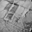
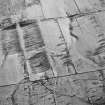
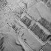
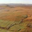
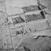
This settlement is situated at the back of a terrace towards the western edge of the Newcastleton crofts and to the N of Ettleton Sike. Roughly rectilinear on plan, it measures 64m from NNE to SSW by 55m transversely internally. On the WNW, where the interior is dug into the back of the terrace, the enclosure bank has been reduced by ploughing to an internal scarp. Around the other three sides the settlement is bounded by two banks and a shallow medial ditch. The banks are largely composed of soil, measuring about 5m in breadth and in places standing up to 1.2m in height. The entrance is at the E of the SSW end. The banks on the E of the entrance return around the terminal of the medial ditch, but on the W they have distinct terminals, with the inner extending across part of the gap to narrow the entrance. Two croft boundaries overlie the settlement, the northern of which is flanked by a drainage ditch; this has sectioned the NNE side of the enclosure boundary.
(LID96 298)
Visited by RCAHMS (DCC) 17 April 1996

