
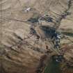
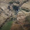
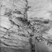
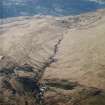
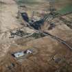
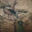
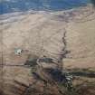
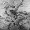
Garelochhead, Mod Military Training Area


Firing Range (20th Century), Military Training Site (20th Century)
Site Name Garelochhead, Mod Military Training Area
Classification Firing Range (20th Century), Military Training Site (20th Century)
Alternative Name(s) The Strone
Canmore ID 162559
Site Number NS29SE 7
NGR NS 2500 9200
NGR Description Centred NS 25 92
Datum OSGB36 - NGR
Permalink http://canmore.org.uk/site/162559


- Council Argyll And Bute
- Parish Rhu
- Former Region Strathclyde
- Former District Dumbarton
- Former County Dunbartonshire
NS29SE 7 centred 25 92
Extends onto map sheets NN20SE, and NS29NE.
For adjacent Ardgartan Forest MOD Training Camp, see NN20SW 9 and the training base see NS29SE 9.
A disused rifle range has been recorded on oblique aerial photographs (RCAHMSAP) on the hillside near the top of the Faslane Burn.
Information from RCAHMS (DCC) 16 November 2004
The training area is bounded in the N by Maol Odhar, the E, Beinn Chaorach, the S by the A 817 and the W by the 220m contour line near the Faslane Burn.
The area is shown on the current OS 1:25,000 scale Explorer series of maps.
Information from RCAHMS (DE), Janaury 2007

