Knock Of Alves
Stone Circle (Neolithic) - (Bronze Age)
Site Name Knock Of Alves
Classification Stone Circle (Neolithic) - (Bronze Age)
Canmore ID 16234
Site Number NJ16SE 7
NGR NJ 1621 6278
Datum OSGB36 - NGR
Permalink http://canmore.org.uk/site/16234
- Council Moray
- Parish Alves
- Former Region Grampian
- Former District Moray
- Former County Morayshire
NJ16SE 7 1621 6278.
(NJ 163 626) Beside the loch on the south side (of the Knock of Alves?) there stood, formerly, a stone circle.
H B Mackintosh 1924.
(NJ 162 628) A stone circle stands just north of a path in the wood and 200m south of York Tower.
Five stones are standing and one has fallen. There is an outlier some 7m to the west.
The stones are about 1m square and 1.2m above the surface. The diameter of the circle is about 7m.
I Keillar 1970.
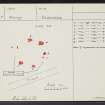
A stone circle, at NJ 1621 6278, inconspicuously situated in a glade.
It consists of six rough boulders standing to a maximum height of 1.3m and measures about 10.0m overall diameter with the interior appearing slightly dished. The triangular top of another stone of uncertain association is visible in the E, and two other stones obscured by leaf mould were revealed by probing, which indicated soil build up of at least 0.5m. The alleged outlying stone to the W is probably a fortuitous naturally placed boulder.
Surveyed at 1/2500.
Visited by OS (R L) 26 January 1972.


