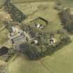
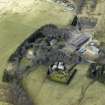
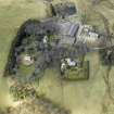
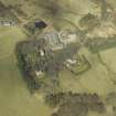
Accessibility

Font Size

100% 150% 200%

Background Colour

Default Contrast
Close Reset

Cranshaws Farm

Farmhouse (Period Unassigned)

Site Name Cranshaws Farm

Classification Farmhouse (Period Unassigned)

Canmore ID 162046

Site Number NT66SE 19

NGR NT 68190 61741

Datum OSGB36 - NGR

Permalink http://canmore.org.uk/site/162046

Ordnance Survey licence number AC0000807262. All rights reserved.
Canmore Disclaimer. © Bluesky International Limited 2025. Public Sector Viewing Terms

Toggle Aerial | View on large map

Digital Images

Oblique aerial view centred on the remains of the tower-house and the farmsteading, stable and farmhouse, taken from the WNW.
Oblique aerial view centred on the remains of the tower-house and the farmsteading, stable and farmhouse, taken from the WNW.Cranshaws Farm, NT66SE 19, Ordnance Survey index card, RectoOblique aerial view centred on the remains of the tower-house and the farmsteading, stable and farmhouse, taken from the ESE.Oblique aerial view centred on the remains of the tower-house and the farmsteading, stable and farmhouse, taken from the SE.Oblique aerial view centred on the remains of the tower-house and the farmsteading, stable and farmhouse, taken from the SSW.

Administrative Areas

  • Council Scottish Borders, The
  • Parish Cranshaws
  • Former Region Borders
  • Former District Berwickshire
  • Former County Berwickshire

Archaeology Notes

NT66SE 19.00 68190 61741

NT66SE 19.01 68252 61843 Gateway to Stable Courtyard

NT66SE 19.02 68215 61824 Stable Courtyard

NT66SE 19.03 38199 61731 Sundial

References

MyCanmore Image Contributions


Contribute an Image

MyCanmore Text Contributions