
Pricing Change
New pricing for orders of material from this site will come into place shortly. Charges for supply of digital images, digitisation on demand, prints and licensing will be altered.
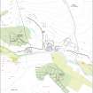
Toft Knowes


Archaeological Landscape (Prehistoric) - (Post Medieval)
Site Name Toft Knowes
Classification Archaeological Landscape (Prehistoric) - (Post Medieval)
Canmore ID 161994
Site Number NY49NE 22
NGR NY 4981 9553
Datum OSGB36 - NGR
Permalink http://canmore.org.uk/site/161994


- Council Scottish Borders, The
- Parish Castleton
- Former Region Borders
- Former District Roxburgh
- Former County Roxburghshire
Field Visit (17 April 1996)
NY49NE 22.00 4981 9553
NY49NE 22.01 Settlement; Pit (NY 4981 9553, LID96 237)
NY49NE 22.02 Farmstead, Quarries (NY 4952 9573, LID96 236)
NY49NE 22.03 Field-system; Rig (NY 4973 9559)
On a broad terrace called Tofts Knowes, there is a prehistoric settlement, a farmstead, a field-system, some rig, some quarries and a pit.
(LID96 236-7)
Visited by RCAHMS (PJD) 17 April 1996

