
Lady's Knowe


Bank (Earthwork) (Period Unknown), Cultivation Terrace(S) (Period Unknown), Field System (Prehistoric) - (Post Medieval), Settlement (Later Prehistoric), Track (Period Unknown)
Site Name Lady's Knowe
Classification Bank (Earthwork) (Period Unknown), Cultivation Terrace(S) (Period Unknown), Field System (Prehistoric) - (Post Medieval), Settlement (Later Prehistoric), Track (Period Unknown)
Canmore ID 161972
Site Number NY49NE 13
NGR NY 4904 9624
Datum OSGB36 - NGR
Permalink http://canmore.org.uk/site/161972

- Council Scottish Borders, The
- Parish Castleton
- Former Region Borders
- Former District Roxburgh
- Former County Roxburghshire
Field Visit (18 April 1996 - 1 May 1996)
NY49NE 13.00 4904 9624
NY49NE 13.01 4903 9621 Farmstead; Rig; Stock enclosures
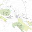
Lady's Knowe is occupied by a prehistoric settlement, a field-system with a trackway, cultivation terraces, a farmstead, three stock enclosures and some rig. The settlement enclosure is situated on the E end of the summit of Lady's Knowe, and the later farmstead is built into its SW quadrant; the sides of the hill are covered with the remains of the prehistoric and later field-systems.
The prehistoric settlement which occupies the E end of Lady's Knowe, is oval on plan and measures 68m from NNE to SSW by 51m transversely within stony banks up to 3.4m in thickness and up to 0.5m height. There is an entrance on the ENE, with expanded bank terminals to either side of the gap. The walls are very much reduced on the E, and the interior is scooped into the slope on the W. A later farmstead has been built into the SW quadrant (NY49NE 13.01).
The trackway, or droveway, may be traced from near the entrance to the settlement for a distance of about 250m downhill to the SE (NY 4910 9624 to NY 4933 9613). Near its SE end, it is cut by a later dyke (NY49NE 3). The droveway is defined by a bank on either side of a hollow way, and forms part of a field-system that extends over a distance of about 550m from NW to SE by 200m transversely on the NE flank of the hill. A head-dyke extends NW along the contour from the head of the droveway, and there are traces of several banks dropping down the slope to form sub-divisions. There are a number of small cairns scattered about the fields, which are overlain by some rig (see NY49NE 13.01).
The cultivation terraces occupy the SW flank of the hill and extend from the stock enclosures in the SE (NY49SE 13.01) over an area measuring about 470m from E to the W by up to 150m transversely. At the SE end the terraces are overlain by rig and some turf-banked enclosures. One substantial stony bank runs over the hill from N to S to the N for a distance of 270m. As it crosses the top of the hill it bifurcates into two parallel banks a few metres apart. Its relationship to the field-system and the cultivation terraces is unknown.
(LID96 270)
Visited by RCAHMS (PJD) 18 April and 1 May 1996

