
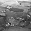
Burnbrae, Farm Cottages


Cottage (Period Unassigned)
Site Name Burnbrae, Farm Cottages
Classification Cottage (Period Unassigned)
Canmore ID 161933
Site Number NT63NE 21.01
NGR NT 6832 3729
Datum OSGB36 - NGR
Permalink http://canmore.org.uk/site/161933

- Council Scottish Borders, The
- Parish Nenthorn
- Former Region Borders
- Former District Roxburgh
- Former County Berwickshire
Though Burnbrae was somewhat smaller than some of the other farms that made up the Nenthorn estate, it possessed the same range of buildings as its larger counterparts.
Among the buildings constructed here as part of the agricultural improvements was a row of farm cottages which, like the farmsteading and the farmhouse, are of nineteenth-century date. These would have provided accommodation for four farm workers and their families.
Text prepared by RCAHMS as part of the Accessing Scotland's Past project

