
Burnbrae


Farmhouse (Period Unassigned), Farmstead (Period Unassigned)
Site Name Burnbrae
Classification Farmhouse (Period Unassigned), Farmstead (Period Unassigned)
Canmore ID 161931
Site Number NT63NE 21
NGR NT 6848 3716
Datum OSGB36 - NGR
Permalink http://canmore.org.uk/site/161931


- Council Scottish Borders, The
- Parish Nenthorn
- Former Region Borders
- Former District Roxburgh
- Former County Berwickshire
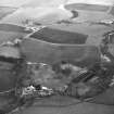
Burnbrae farm once formed part of the Nenthorn estate. Like most, if not all, of the farms throughout the Merse which formed part of agricultural improvements, it was predominantly arable, with livestock farming carried out on a subsidiary basis.
The farmhouse at Burnbrae is two storeys high, and probably dates to the mid- or late nineteenth century. The nearby steading included three cattle courts where livestock were kept over the winter, plus a number of additional buildings such as stables and storage sheds for fodder. There was also a threshing mill where grain was processed on site.
Throughout the twentieth century, the various farms which made up the Nenthorn estate were sold. Burnbrae, which was left to operate as the 'home farm' of the estate, was the last to be sold in the late twentieth century.
Text prepared by RCAHMS as part of the Accessing Scotland's Past project

