
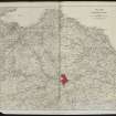
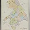
Whitehill


Farmhouse (Period Unassigned), Farmstead (Period Unassigned)
Site Name Whitehill
Classification Farmhouse (Period Unassigned), Farmstead (Period Unassigned)
Alternative Name(s) Nenthorn Estate; Whitehill Farm; Whitehill House
Canmore ID 161927
Site Number NT63NE 19
NGR NT 6833 3868
Datum OSGB36 - NGR
Permalink http://canmore.org.uk/site/161927
Ordnance Survey licence number AC0000807262. All rights reserved.
Canmore Disclaimer.
© Bluesky International Limited 2025. Public Sector Viewing Terms
- Correction
- Favourite

SC 2115696
Estate Exchange. Mertoun. No 1492. Sale brochure
Collection of sale catalogues relating to Scottish estates
16/7/1912
© Courtesy of HES (Estates Exchange Collection)

SC 2115700
Estate Exchange. Mertoun. No 1492. Sale brochure
Collection of sale catalogues relating to Scottish estates
16/7/1912
© Courtesy of HES (Estates Exchange Collection)

SC 2115705
Estate Exchange. Mertoun. No 1492. Sale brochure
Collection of sale catalogues relating to Scottish estates
16/7/1912
© Courtesy of HES (Estates Exchange Collection)

SC 2115709
Estate Exchange. Mertoun. No 1492. Sale brochure
Collection of sale catalogues relating to Scottish estates
16/7/1912
© Courtesy of HES (Estates Exchange Collection)

SC 2115721
Estate Exchange. Mertoun. No 1492. Sale brochure
Collection of sale catalogues relating to Scottish estates
16/7/1912
© Courtesy of HES (Estates Exchange Collection)

SC 2115723
Estate Exchange. Mertoun. No 1492. Sale brochure
Collection of sale catalogues relating to Scottish estates
16/7/1912
© Courtesy of HES (Estates Exchange Collection)

SC 2115732
Estate Exchange. Mertoun. No 1492. Sale brochure
Collection of sale catalogues relating to Scottish estates
16/7/1912
© Courtesy of HES (Estates Exchange Collection)

SC 2115734
Estate Exchange. Mertoun. No 1492. Sale brochure
Collection of sale catalogues relating to Scottish estates
16/7/1912
© Courtesy of HES (Estates Exchange Collection)

SC 2115735
Estate Exchange. Mertoun. No 1492. Sale brochure
Collection of sale catalogues relating to Scottish estates
16/7/1912
© Courtesy of HES (Estates Exchange Collection)

SC 2115740
Estate Exchange. Mertoun. No 1492. Sale brochure
Collection of sale catalogues relating to Scottish estates
16/7/1912
© Courtesy of HES (Estates Exchange Collection)

SC 2115742
Estate Exchange. Mertoun. No 1492. Sale brochure
Collection of sale catalogues relating to Scottish estates
16/7/1912
© Courtesy of HES (Estates Exchange Collection)

SC 2115743
Estate Exchange. Mertoun. No 1492. Sale brochure
Collection of sale catalogues relating to Scottish estates
16/7/1912
© Courtesy of HES (Estates Exchange Collection)

SC 2115744
Estate Exchange. Mertoun. No 1492. Sale brochure
Collection of sale catalogues relating to Scottish estates
16/7/1912
© Courtesy of HES (Estates Exchange Collection)

SC 2115778
Estate Exchange. Nenthorn Estate. No 1493, sale brochure
Collection of sale catalogues relating to Scottish estates
7/7/1914
© Courtesy of HES (Estates Exchange Collection)

SC 2115780
Estate Exchange. Nenthorn Estate. No 1493, sale brochure
Collection of sale catalogues relating to Scottish estates
7/7/1914
© Courtesy of HES (Estates Exchange Collection)

SC 2115678
Estate Exchange. Mertoun. No 1492. Sale brochure
Collection of sale catalogues relating to Scottish estates
16/7/1912
© Courtesy of HES (Estates Exchange Collection)

SC 2115682
Estate Exchange. Mertoun. No 1492. Sale brochure
Collection of sale catalogues relating to Scottish estates
16/7/1912
© Courtesy of HES (Estates Exchange Collection)

SC 2115685
Estate Exchange. Mertoun. No 1492. Sale brochure
Collection of sale catalogues relating to Scottish estates
16/7/1912
© Courtesy of HES (Estates Exchange Collection)

SC 2115704
Estate Exchange. Mertoun. No 1492. Sale brochure
Collection of sale catalogues relating to Scottish estates
16/7/1912
© Courtesy of HES (Estates Exchange Collection)

SC 2115706
Estate Exchange. Mertoun. No 1492. Sale brochure
Collection of sale catalogues relating to Scottish estates
16/7/1912
© Courtesy of HES (Estates Exchange Collection)

SC 2115707
Estate Exchange. Mertoun. No 1492. Sale brochure
Collection of sale catalogues relating to Scottish estates
16/7/1912
© Courtesy of HES (Estates Exchange Collection)

SC 2115712
Estate Exchange. Mertoun. No 1492. Sale brochure
Collection of sale catalogues relating to Scottish estates
16/7/1912
© Courtesy of HES (Estates Exchange Collection)

SC 2115719
Estate Exchange. Mertoun. No 1492. Sale brochure
Collection of sale catalogues relating to Scottish estates
16/7/1912
© Courtesy of HES (Estates Exchange Collection)

SC 2115722
Estate Exchange. Mertoun. No 1492. Sale brochure
Collection of sale catalogues relating to Scottish estates
16/7/1912
© Courtesy of HES (Estates Exchange Collection)

SC 2115724
Estate Exchange. Mertoun. No 1492. Sale brochure
Collection of sale catalogues relating to Scottish estates
16/7/1912
© Courtesy of HES (Estates Exchange Collection)

SC 2115739
Estate Exchange. Mertoun. No 1492. Sale brochure
Collection of sale catalogues relating to Scottish estates
16/7/1912
© Courtesy of HES (Estates Exchange Collection)

SC 2115783
Estate Exchange. Nenthorn Estate. No 1493, sale brochure
Collection of sale catalogues relating to Scottish estates
7/7/1914
© Courtesy of HES (Estates Exchange Collection)

SC 2115802
Estate Exchange. Nenthorn Estate. No 1493, sale brochure
Collection of sale catalogues relating to Scottish estates
7/7/1914
© Courtesy of HES (Estates Exchange Collection)

SC 2115679
Estate Exchange. Mertoun. No 1492. Sale brochure
Collection of sale catalogues relating to Scottish estates
16/7/1912
© Courtesy of HES (Estates Exchange Collection)

SC 2115689
Estate Exchange. Mertoun. No 1492. Sale brochure
Collection of sale catalogues relating to Scottish estates
16/7/1912
© Courtesy of HES (Estates Exchange Collection)

SC 2115692
Estate Exchange. Mertoun. No 1492. Sale brochure
Collection of sale catalogues relating to Scottish estates
16/7/1912
© Courtesy of HES (Estates Exchange Collection)

SC 2115698
Estate Exchange. Mertoun. No 1492. Sale brochure
Collection of sale catalogues relating to Scottish estates
16/7/1912
© Courtesy of HES (Estates Exchange Collection)

SC 2115717
Estate Exchange. Mertoun. No 1492. Sale brochure
Collection of sale catalogues relating to Scottish estates
16/7/1912
© Courtesy of HES (Estates Exchange Collection)

SC 2115733
Estate Exchange. Mertoun. No 1492. Sale brochure
Collection of sale catalogues relating to Scottish estates
16/7/1912
© Courtesy of HES (Estates Exchange Collection)

SC 2115736
Estate Exchange. Mertoun. No 1492. Sale brochure
Collection of sale catalogues relating to Scottish estates
16/7/1912
© Courtesy of HES (Estates Exchange Collection)

SC 2115786
Estate Exchange. Nenthorn Estate. No 1493, sale brochure
Collection of sale catalogues relating to Scottish estates
7/7/1914
© Courtesy of HES (Estates Exchange Collection)

SC 2115787
Estate Exchange. Nenthorn Estate. No 1493, sale brochure
Collection of sale catalogues relating to Scottish estates
7/7/1914
© Courtesy of HES (Estates Exchange Collection)

SC 2115791
Estate Exchange. Nenthorn Estate. No 1493, sale brochure
Collection of sale catalogues relating to Scottish estates
7/7/1914
© Courtesy of HES (Estates Exchange Collection)

SC 2115793
Estate Exchange. Nenthorn Estate. No 1493, sale brochure
Collection of sale catalogues relating to Scottish estates
7/7/1914
© Courtesy of HES (Estates Exchange Collection)

SC 2115794
Estate Exchange. Nenthorn Estate. No 1493, sale brochure
Collection of sale catalogues relating to Scottish estates
7/7/1914
© Courtesy of HES (Estates Exchange Collection)

SC 2115798
Estate Exchange. Nenthorn Estate. No 1493, sale brochure
Collection of sale catalogues relating to Scottish estates
7/7/1914
© Courtesy of HES (Estates Exchange Collection)

SC 2115799
Estate Exchange. Nenthorn Estate. No 1493, sale brochure
Collection of sale catalogues relating to Scottish estates
7/7/1914
© Courtesy of HES (Estates Exchange Collection)

SC 2115801
Estate Exchange. Nenthorn Estate. No 1493, sale brochure
Collection of sale catalogues relating to Scottish estates
7/7/1914
© Courtesy of HES (Estates Exchange Collection)

SC 2115675
Estate Exchange. Mertoun. No 1492. Sale brochure
Collection of sale catalogues relating to Scottish estates
16/7/1912
© Courtesy of HES (Estates Exchange Collection)

SC 2115676
Estate Exchange. Mertoun. No 1492. Sale brochure
Collection of sale catalogues relating to Scottish estates
16/7/1912
© Courtesy of HES (Estates Exchange Collection)

SC 2115681
Estate Exchange. Mertoun. No 1492. Sale brochure
Collection of sale catalogues relating to Scottish estates
16/7/1912
© Courtesy of HES (Estates Exchange Collection)

SC 2115683
Estate Exchange. Mertoun. No 1492. Sale brochure
Collection of sale catalogues relating to Scottish estates
16/7/1912
© Courtesy of HES (Estates Exchange Collection)

SC 2115693
Estate Exchange. Mertoun. No 1492. Sale brochure
Collection of sale catalogues relating to Scottish estates
16/7/1912
© Courtesy of HES (Estates Exchange Collection)

SC 2115710
Estate Exchange. Mertoun. No 1492. Sale brochure
Collection of sale catalogues relating to Scottish estates
16/7/1912
© Courtesy of HES (Estates Exchange Collection)

SC 2115779
Estate Exchange. Nenthorn Estate. No 1493, sale brochure
Collection of sale catalogues relating to Scottish estates
7/7/1914
© Courtesy of HES (Estates Exchange Collection)

SC 2115785
Estate Exchange. Nenthorn Estate. No 1493, sale brochure
Collection of sale catalogues relating to Scottish estates
7/7/1914
© Courtesy of HES (Estates Exchange Collection)

SC 2115800
Estate Exchange. Nenthorn Estate. No 1493, sale brochure
Collection of sale catalogues relating to Scottish estates
7/7/1914
© Courtesy of HES (Estates Exchange Collection)

SC 2115687
Estate Exchange. Mertoun. No 1492. Sale brochure
Collection of sale catalogues relating to Scottish estates
16/7/1912
© Courtesy of HES (Estates Exchange Collection)

SC 2115691
Estate Exchange. Mertoun. No 1492. Sale brochure
Collection of sale catalogues relating to Scottish estates
16/7/1912
© Courtesy of HES (Estates Exchange Collection)

SC 2115695
Estate Exchange. Mertoun. No 1492. Sale brochure
Collection of sale catalogues relating to Scottish estates
16/7/1912
© Courtesy of HES (Estates Exchange Collection)

SC 2115714
Estate Exchange. Mertoun. No 1492. Sale brochure
Collection of sale catalogues relating to Scottish estates
16/7/1912
© Courtesy of HES (Estates Exchange Collection)

SC 2115715
Estate Exchange. Mertoun. No 1492. Sale brochure
Collection of sale catalogues relating to Scottish estates
16/7/1912
© Courtesy of HES (Estates Exchange Collection)

SC 2115716
Estate Exchange. Mertoun. No 1492. Sale brochure
Collection of sale catalogues relating to Scottish estates
16/7/1912
© Courtesy of HES (Estates Exchange Collection)

SC 2115728
Estate Exchange. Mertoun. No 1492. Sale brochure
Collection of sale catalogues relating to Scottish estates
16/7/1912
© Courtesy of HES (Estates Exchange Collection)

SC 2115776
Estate Exchange. Nenthorn Estate. No 1493, sale brochure
Collection of sale catalogues relating to Scottish estates
7/7/1914
© Courtesy of HES (Estates Exchange Collection)

SC 2115781
Estate Exchange. Nenthorn Estate. No 1493, sale brochure
Collection of sale catalogues relating to Scottish estates
7/7/1914
© Courtesy of HES (Estates Exchange Collection)

SC 2115797
Estate Exchange. Nenthorn Estate. No 1493, sale brochure
Collection of sale catalogues relating to Scottish estates
7/7/1914
© Courtesy of HES (Estates Exchange Collection)

SC 2115680
Estate Exchange. Mertoun. No 1492. Sale brochure
Collection of sale catalogues relating to Scottish estates
16/7/1912
© Courtesy of HES (Estates Exchange Collection)

SC 2115688
Estate Exchange. Mertoun. No 1492. Sale brochure
Collection of sale catalogues relating to Scottish estates
16/7/1912
© Courtesy of HES (Estates Exchange Collection)

SC 2115697
Estate Exchange. Mertoun. No 1492. Sale brochure
Collection of sale catalogues relating to Scottish estates
16/7/1912
© Courtesy of HES (Estates Exchange Collection)

SC 2115701
Estate Exchange. Mertoun. No 1492. Sale brochure
Collection of sale catalogues relating to Scottish estates
16/7/1912
© Courtesy of HES (Estates Exchange Collection)

SC 2115708
Estate Exchange. Mertoun. No 1492. Sale brochure
Collection of sale catalogues relating to Scottish estates
16/7/1912
© Courtesy of HES (Estates Exchange Collection)

SC 2115718
Estate Exchange. Mertoun. No 1492. Sale brochure
Collection of sale catalogues relating to Scottish estates
16/7/1912
© Courtesy of HES (Estates Exchange Collection)

SC 2115726
Estate Exchange. Mertoun. No 1492. Sale brochure
Collection of sale catalogues relating to Scottish estates
16/7/1912
© Courtesy of HES (Estates Exchange Collection)

SC 2115730
Estate Exchange. Mertoun. No 1492. Sale brochure
Collection of sale catalogues relating to Scottish estates
16/7/1912
© Courtesy of HES (Estates Exchange Collection)

SC 2115731
Estate Exchange. Mertoun. No 1492. Sale brochure
Collection of sale catalogues relating to Scottish estates
16/7/1912
© Courtesy of HES (Estates Exchange Collection)

SC 2115741
Estate Exchange. Mertoun. No 1492. Sale brochure
Collection of sale catalogues relating to Scottish estates
16/7/1912
© Courtesy of HES (Estates Exchange Collection)

SC 2115784
Estate Exchange. Nenthorn Estate. No 1493, sale brochure
Collection of sale catalogues relating to Scottish estates
7/7/1914
© Courtesy of HES (Estates Exchange Collection)

SC 2115788
Estate Exchange. Nenthorn Estate. No 1493, sale brochure
Collection of sale catalogues relating to Scottish estates
7/7/1914
© Courtesy of HES (Estates Exchange Collection)

SC 2115796
Estate Exchange. Nenthorn Estate. No 1493, sale brochure
Collection of sale catalogues relating to Scottish estates
7/7/1914
© Courtesy of HES (Estates Exchange Collection)

SC 2115690
Estate Exchange. Mertoun. No 1492. Sale brochure
Collection of sale catalogues relating to Scottish estates
16/7/1912
© Courtesy of HES (Estates Exchange Collection)

SC 2115702
Estate Exchange. Mertoun. No 1492. Sale brochure
Collection of sale catalogues relating to Scottish estates
16/7/1912
© Courtesy of HES (Estates Exchange Collection)

SC 2115703
Estate Exchange. Mertoun. No 1492. Sale brochure
Collection of sale catalogues relating to Scottish estates
16/7/1912
© Courtesy of HES (Estates Exchange Collection)

SC 2115725
Estate Exchange. Mertoun. No 1492. Sale brochure
Collection of sale catalogues relating to Scottish estates
16/7/1912
© Courtesy of HES (Estates Exchange Collection)

SC 2115727
Estate Exchange. Mertoun. No 1492. Sale brochure
Collection of sale catalogues relating to Scottish estates
16/7/1912
© Courtesy of HES (Estates Exchange Collection)

SC 2115737
Estate Exchange. Mertoun. No 1492. Sale brochure
Collection of sale catalogues relating to Scottish estates
16/7/1912
© Courtesy of HES (Estates Exchange Collection)

SC 2115738
Estate Exchange. Mertoun. No 1492. Sale brochure
Collection of sale catalogues relating to Scottish estates
16/7/1912
© Courtesy of HES (Estates Exchange Collection)

SC 2115745
Estate Exchange. Mertoun. No 1492. Sale brochure
Collection of sale catalogues relating to Scottish estates
16/7/1912
© Courtesy of HES (Estates Exchange Collection)

SC 2115746
Estate Exchange. Mertoun. No 1492. Sale brochure
Collection of sale catalogues relating to Scottish estates
16/7/1912
© Courtesy of HES (Estates Exchange Collection)

SC 2115782
Estate Exchange. Nenthorn Estate. No 1493, sale brochure
Collection of sale catalogues relating to Scottish estates
7/7/1914
© Courtesy of HES (Estates Exchange Collection)

SC 2115789
Estate Exchange. Nenthorn Estate. No 1493, sale brochure
Collection of sale catalogues relating to Scottish estates
7/7/1914
© Courtesy of HES (Estates Exchange Collection)

SC 2115790
Estate Exchange. Nenthorn Estate. No 1493, sale brochure
Collection of sale catalogues relating to Scottish estates
7/7/1914
© Courtesy of HES (Estates Exchange Collection)

SC 2115792
Estate Exchange. Nenthorn Estate. No 1493, sale brochure
Collection of sale catalogues relating to Scottish estates
7/7/1914
© Courtesy of HES (Estates Exchange Collection)

SC 2115803
Estate Exchange. Nenthorn Estate. No 1493, sale brochure
Collection of sale catalogues relating to Scottish estates
7/7/1914
© Courtesy of HES (Estates Exchange Collection)

SC 2115804
Estate Exchange. Nenthorn Estate. No 1493, sale brochure
Collection of sale catalogues relating to Scottish estates
7/7/1914
© Courtesy of HES (Estates Exchange Collection)

SC 2115677
Estate Exchange. Mertoun. No 1492. Sale brochure
Collection of sale catalogues relating to Scottish estates
16/7/1912
© Courtesy of HES (Estates Exchange Collection)

SC 2115684
Estate Exchange. Mertoun. No 1492. Sale brochure
Collection of sale catalogues relating to Scottish estates
16/7/1912
© Courtesy of HES (Estates Exchange Collection)

SC 2115686
Estate Exchange. Mertoun. No 1492. Sale brochure
Collection of sale catalogues relating to Scottish estates
16/7/1912
© Courtesy of HES (Estates Exchange Collection)

SC 2115694
Estate Exchange. Mertoun. No 1492. Sale brochure
Collection of sale catalogues relating to Scottish estates
16/7/1912
© Courtesy of HES (Estates Exchange Collection)

SC 2115699
Estate Exchange. Mertoun. No 1492. Sale brochure
Collection of sale catalogues relating to Scottish estates
16/7/1912
© Courtesy of HES (Estates Exchange Collection)

SC 2115711
Estate Exchange. Mertoun. No 1492. Sale brochure
Collection of sale catalogues relating to Scottish estates
16/7/1912
© Courtesy of HES (Estates Exchange Collection)

SC 2115713
Estate Exchange. Mertoun. No 1492. Sale brochure
Collection of sale catalogues relating to Scottish estates
16/7/1912
© Courtesy of HES (Estates Exchange Collection)

SC 2115720
Estate Exchange. Mertoun. No 1492. Sale brochure
Collection of sale catalogues relating to Scottish estates
16/7/1912
© Courtesy of HES (Estates Exchange Collection)

SC 2115729
Estate Exchange. Mertoun. No 1492. Sale brochure
Collection of sale catalogues relating to Scottish estates
16/7/1912
© Courtesy of HES (Estates Exchange Collection)

SC 2115777
Estate Exchange. Nenthorn Estate. No 1493, sale brochure
Collection of sale catalogues relating to Scottish estates
7/7/1914
© Courtesy of HES (Estates Exchange Collection)


First 100 images shown. See the Collections panel (below) for a link to all digital images.
- Council Scottish Borders, The
- Parish Nenthorn
- Former Region Borders
- Former District Roxburgh
- Former County Berwickshire
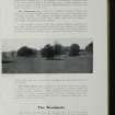
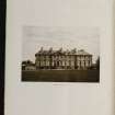
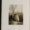
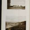
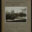
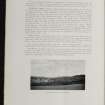
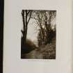
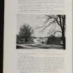
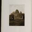
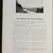
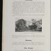
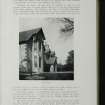
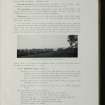
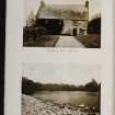
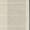
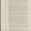
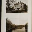
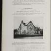
Whitehill farm once formed part of the Nenthorn estate. Like many other farms in the area around Nenthorn and Smailholm, it was transformed by the agricultural improvements of the late eighteenth and nineteenth centuries.
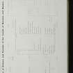
The farmhouse at Whitehill is a two-storeyed building of nineteenth-century date.
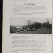
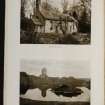
Located nearby was a steading which was designed and laid out as a predominantly arable farm, including a covered cattle court, stabling for 15 horses and room to keep a gig and carts.
A threshing mill, originally water-powered, also formed part of the steading. The mill pond, plus its associated dam and lade, can still be identified as an area of marshland and an associated water channel on the 1988 1:10000 map of the area. By the early twentieth century, however, a steam engine had been installed to power the machinery.
Text prepared by RCAHMS as part of the Accessing Scotland's Past project

