
Pricing Change
New pricing for orders of material from this site will come into place shortly. Charges for supply of digital images, digitisation on demand, prints and licensing will be altered.
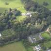
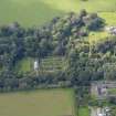
Dunninald Castle, Stables


Stable(S) (Period Unassigned)
Site Name Dunninald Castle, Stables
Classification Stable(S) (Period Unassigned)
Alternative Name(s) Dunninald Castle Policies
Canmore ID 161890
Site Number NO75SW 29.07
NGR NO 70504 54244
Datum OSGB36 - NGR
Permalink http://canmore.org.uk/site/161890


- Council Angus
- Parish Craig
- Former Region Tayside
- Former District Angus
- Former County Angus
NO75SW 29.07 70504 54244
NO75SW 29.07 70504 54244
Collection item PA 229/7/27/1 has been linked tentatively with this site despite the annotation 'Dunninald Mains'. See also NO75SW 29.01 70600 54265, Dunninald Mains. Anne Cassells, 30 August 2007.
Standing Building Recording (14 December 2017)
NO 70508 54264 A Level 1 standing building survey was
carried out, 14 December 2017, prior to the conversion of
farmsteadings to housing. The steadings may have been
originally constructed in the late 18th century. By the mid-19th
century (possibly during the building phase in 1823–4, when
the castle was rebuilt for Peter Arkley) the steadings were
redesigned. There is a doocot in the centre of the internal
courtyard.
Archive: NRHE
Funder: Private individual
Alison Cameron – Cameron Archaeology
(Source: DES, Volume 19)
Oasis (camerona1-308700) 18 May 2018

