
Following the launch of trove.scot in February 2025 we are now planning the retiral of some of our webservices. Canmore will be switched off on 24th June 2025. Information about the closure can be found on the HES website: Retiral of HES web services | Historic Environment Scotland
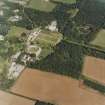
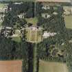
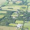
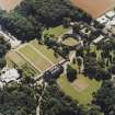
Gordonstoun House


Country House (17th Century), School (20th Century), Tower House (Medieval)
Site Name Gordonstoun House
Classification Country House (17th Century), School (20th Century), Tower House (Medieval)
Alternative Name(s) Gordonstoun; Plewlands; Gordonstoun School; Gordonstown House
Canmore ID 16143
Site Number NJ16NE 7
NGR NJ 18440 68988
Datum OSGB36 - NGR
Permalink http://canmore.org.uk/site/16143


- Council Moray
- Parish Drainie
- Former Region Grampian
- Former District Moray
- Former County Morayshire
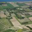
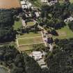
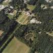
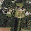
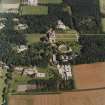
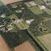
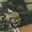
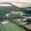
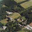
The main house began as a tower in the sixteenth century, the large wings were added in the early seveneteenth century and refaced in the late eighteenth century with the ashlar frontage. The garden (south) front still shows signs of rubble construction and its earlier history.
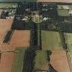
NJ16NE 7.00 18440 68988
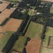
NJ16NE 7.01 19282 69565 East Lodge
NJ16NE 7.02 19510 69043 Michael Kirk Lodge
NJ16NE 7.03 182 693 North Drive, Gates and Gate Piers
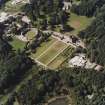
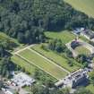
NJ16NE 7.04 18374 68868 Round Square (Mains Farm)
NJ16NE 7.05 18334 68969 Round Square, Dovecot
NJ16NE 7.06 17697 68864 West Lodge and Gate Piers
NJ16NE 7.07 18809 69410 Windmill Dovecot
NJ16NE 7.08 18168 68969 Cumming House
NJ16NE 7.09 1873 6925 Fire Station
NJ16NE 7.10 1768 6889 Bellwood Cottage
NJ16NE 7.11 1884 6937 Windmill Cottage
NJ16NE 7.12 1840 6890 Chapel
NJ16NE 7.14 18470 69004 Water Tower
For Michael Kirk (Gordonstoun House mausoleum and Gordonstoun School chapel) at NJ 1928 6893 and Michael Kirk, Cross (Ogston Market Cross) at NJ 1928 6892, see NJ16NE 16.00 and NJ16NE 16.01 respectively. For Duffus House (NJ 1757 6853) and lodge (NJ 1724 6820) which form part of the school, see NJ16NE 27.00 and NJ16NE 27.01 respectively.
(NJ 1843 6898) Gordonstown (NAT)
OS 6" map, Morayshire, 2nd ed., (1906)
Gordonstoun policies and the school premises extend into Duffus parish.
The house of Plewlands was purchased by Sir Robert Gordon in 1638 and renamed 'Gordonstoun'. Alterations by him and his successor gave the house a symmetrical south frontage and further alterations in the late 18th century gave it its classical north front, but it appears quite possible that the west wing may represent the original 15th century tower-house and that portions of along 16th century wing are incorporated in the southern part of the central block.
R G Cant 1948.
The Round Square (stables etc.) was built by Sir Robt. Gordon (1674-1704)
Visited by OS (A L F R) 23 July 1959; Plans and particulars with Scottish Historical Building Soc c/o MoW, Edinburgh)
Adequately described above. The Round Square is at NJ 1836 6889
The modern name is 'Gordonstoun'. Now a school.
Visited by OS (R D L) 30 November 1962.
Gordonstoun School [NAT]
OS 1:10,560 map, 1969.
NMRS REFERENCE:
Architect:- 1775-76
Scotland's Magazine July 1962 p. 8 - article and photographs
"The History of the Estate of Gordonstoun" (pamphlet missing at time of upgrade)
EXTERNAL REFERENCE:
SRO
1/2 years wages of Gardeners Gordon House from 23 May 1726
Geo. Kay Factor to Robert Gordon #1.80 Scots
Drainie Gordon House
Letter: William Lindsay to Baillie Key, Factor to Sir Robert Gordon. He has sent 20 bars of lead to complete the work at Sir Robert Gordon's house.
Wishes payment of #46.14.4
6 September 1727 CS228/Miscell.Box 6
REFERENCE:
Two late 19th century photographs in the Inigo Thomas Album, purchased by NMR, Swindon, 1997.
Non-Guardianship Sites Plan Collection, DC23856, 1957
Photographic Survey (1954)
Photographs of buildings in Gordonstoun, Morayshire, by the Scottish National Buildings Record in 1954.
Photographic Survey (20 August 2013)
Photographed on behalf of the Buildings of Scotland publications 2013-14.

