
Gorebridge, Old Shank Bridge


Road Bridge (Period Unassigned)
Site Name Gorebridge, Old Shank Bridge
Classification Road Bridge (Period Unassigned)
Alternative Name(s) Gore Water
Canmore ID 160837
Site Number NT36SW 51
NGR NT 33742 61351
Datum OSGB36 - NGR
Permalink http://canmore.org.uk/site/160837

- Council Midlothian
- Parish Borthwick
- Former Region Lothian
- Former District Midlothian
- Former County Midlothian
NT36SW 51 3371 6135
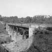
An iron and stone Shank Bridge taking the A7 trunk road over the Gore Water was demolished 1977/78. A replacement was built about 29m to the W as part of the A7 trunk road improvement scheme.
The bridge was built with cast iron and brick piers, decorated stone approaches and a decorated cast iron balustrade.
This bridge replaced an earlier structure annotated as 'Arnsiton Bridge' on the 1st edition of the OS 6-inch map (Edinburghshire, 1854, sheet 13), and which is described in the Object Name Book of the Ordnance Survey as ' A substantial stone bridge over the Gore Burn and the p[roperty of the Trustees of the County Roads'
Information from RCAHMS (DE), December 2006.

