
Following the launch of trove.scot in February 2025 we are now planning the retiral of some of our webservices. Canmore will be switched off on 24th June 2025. Information about the closure can be found on the HES website: Retiral of HES web services | Historic Environment Scotland
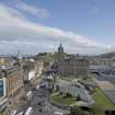
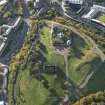
Edinburgh, Calton Hill, Observatory


No Class (Event) (Period Unassigned)
Site Name Edinburgh, Calton Hill, Observatory
Classification No Class (Event) (Period Unassigned)
Alternative Name(s) Old Royal Observatory; Old Observatory
Canmore ID 160783
Site Number NT27SE 202.02
NGR NT 2620 7420
Datum OSGB36 - NGR
Permalink http://canmore.org.uk/site/160783


- Council Edinburgh, City Of
- Parish Edinburgh (Edinburgh, City Of)
- Former Region Lothian
- Former District City Of Edinburgh
- Former County Midlothian
NT27SE 202.02 2620 7420
NT 2620 7420 A watching brief was carried out in March 1997 on four hand-excavated engineering test pits, part of an
assessment of ground conditions associated with the boundary wall of the observatory complex. The pits, located as opposing pairs inside and outside the wall, on the NW corner and on the mid-point of the N wall, revealed identical deposits of 19th-century voided rubble which formed terraced pathways both externally and internally. Excavation was stopped at 1.2m (external) and 1.8m (internal), with the rubble continuing below the base of the test pits.
Sponsor: City of Edinburgh Council.
J A Lawson 1999.
Standing Building Recording (8 November 2016 - 11 July 2018)
As part of a project to renovate the City Observatory AOC Archaeology Group undertook an initial programme of historic building recording
followed by a structural watching brief on all ground-breaking works and renovations to the Observatory and Transit House.
Information from Diana Sproat (AOC Archaeology Group) 20 July 2018. OASIS ID: aocarcha1-274312
Project (8 November 2016 - 20 July 2018)
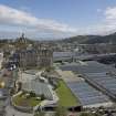
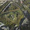
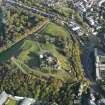
NT 26198 74192 A programme of archaeological work was undertaken, 8 November 2016 – 25 June 2018, during work to the City Observatory and its associated Transit House, together with the demolition of three former observatory domes and a toilet block, in advance of new development.
The City Observatory was constructed in 1818 to a design by William Playfair and replaced an earlier observatory constructed in 1776 by Thomas Short, which was built at the same time as Observatory House. The 2017 – 18 renovations to the observatory removed an internal partition to the ground floor, opening out the two original transit rooms to the E and W, and reinstating its original arrangement. The work also exposed the original character of the W transit room, which had been converted to a lecture room in the 1930s.
The Transit House was built a few years after the City Observatory (but before 1821) and consists of a small building, which originally housed a transit telescope with the meridional windows to the N and S elevations. The building was later converted to accommodation, with a small toilet added to the NW corner. It suffered fire damage at some point and the walls are now blackened with soot. A toilet extension was added to the N side in the late 20th century.
A further dome to the E, called the East Dome, was also exposed. This dome, which had dressed stone foundations with brick construction above, has now been removed. The Tweedie Dome, now largely collapsed, was built in the late 19th century, and was joined by the Cox and Crawford Domes to either side of it in the late 1890s. Another two additional domes were added, one to the immediate NW of the Tweedie Dome, and one separate dome to the E of the City Observatory. The exact dates for these are a little unclear, but they appear to date to the later 20th century.
With the exception of the further exposure of a stone and brick dome to the E of the site and an iron post to the W of the observatory, no archaeological finds or features were identified. It appears that much of the site has been landscaped, with topsoil dumped to create the mound upon which the Royal Observatory was constructed. Indeed, a major programme of landscaping was undertaken in the late 1890s. In all other areas, bedrock was reached 0.3 – 0.8m below the topsoil.
Archive: NRHE (intended)
Funder: City of Edinburgh Council
Diana Sproat – AOC Archaeology Group
(Source: DES Vol 19)
OASIS ID: aocarcha1-274312

