
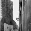
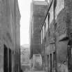
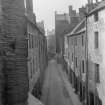
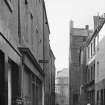
Stirling, St Mary's Wynd, General


General View
Site Name Stirling, St Mary's Wynd, General
Classification General View
Canmore ID 160157
Site Number NS79SE 214
NGR NS 79374 93795
NGR Description From NS 79369 93903 to NS 79372 937105
Datum OSGB36 - NGR
Permalink http://canmore.org.uk/site/160157


- Council Stirling
- Parish Stirling
- Former Region Central
- Former District Stirling
- Former County Stirlingshire
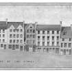
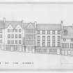
Non-Guardianship Sites Plan Collection, DC28606- DC28611.
NMRS REFERENCE:
Broad Street and St Mary's Wynd.
NMRS drawings STD 143/1, STD 143/6 and STD 153 refer to buildings on Broad Street and the corner building of Broad Street with St Mary's Wynd, which were demolished in the c.1920s. Other buildings now take their place. Former buildings depicted on Epoch 3, 1:2500 Stirlingshire, 1917-18.

