
Pricing Change
New pricing for orders of material from this site will come into place shortly. Charges for supply of digital images, digitisation on demand, prints and licensing will be altered.
Glen Shiel, Telford Bridge


Road Bridge (Period Unassigned)
Site Name Glen Shiel, Telford Bridge
Classification Road Bridge (Period Unassigned)
Alternative Name(s) River Shiel; Loch Duich; Shiel Bridge And Causeway; Sheal Bridge; Kintail
Canmore ID 160112
Site Number NG91NW 11
NGR NG 93549 18869
Datum OSGB36 - NGR
Permalink http://canmore.org.uk/site/160112


- Council Highland
- Parish Glenshiel
- Former Region Highland
- Former District Skye And Lochalsh
- Former County Ross And Cromarty
NG91NW 11 93549 18869
Not to be confused with successor and present Shiel Bridge (upstream, at NG 9390 1873, for which see NG91NW 17.
(Location cited as NG 934 189). Shiel Bridge, built c. 1820, engineer Thomas Telford. A fine singlespan rubble bridge, with a segmental arch and a decorative string course.
J R Hume 1977.
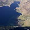
This bridge carries what is apparently the former line of the A87 public road (the military road LIN 510) over the River Shiel about 400m E of its debouchment into upper Loch Duich. It is depicted, but not noted, on the 1971 edition of the OS 1:10,000 map.
The location assigned to this record defines the apparent midpoint of the structure. The available map evidence indicates that it extends from NG c. 93549 18882 to NG c. 93549 18850.
Information from RCAHMS (RJCM), 10 May 2006.
Build (1817)
Completed 1817.
R Paxton and J Shipway, 2007.
Publication Account (2007)
Shiel Bridge, Glenshiel (Loch Duich)
(Institute Civil Engineers Historic Engineering Works no. HEW HEW 0614)
This fine bridge over the Shiel at the south end of Loch Duich, now carrying the A87 road, was designed by Telford and constructed under his direction as engineer to the Highland Roads Commissioners. It formed part of the Kintail Road from Invermoriston to Kyle of Lochalsh.
The bridge, one of five built under the same contract, encountered exceptional difficulties in finding skilled workmen, but was essentially completed by 1817 The bridge is a random rubble-masonry arch of 65 ft span of pleasing elevation with a string course at road level, tapering pilasters at the approaches and vertical spandrel faces. The surveyor for the Kintail Road, which the Commissioners considered second to none in importance of their roads, was John Mitchell.
R Paxton and J Shipway, 2007.
Reproduced from 'Civil Engineering heritage: Scotland - Highlands and Islands' with kind permission from Thomas Telford Publishers.

