
Blairfindy Castle


Tower House (Medieval)
Site Name Blairfindy Castle
Classification Tower House (Medieval)
Alternative Name(s) Castleton Of Blairfindy
Canmore ID 15970
Site Number NJ12NE 4
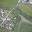
NGR NJ 19834 28642
Datum OSGB36 - NGR
Permalink http://canmore.org.uk/site/15970


- Council Moray
- Parish Inveravon
- Former Region Grampian
- Former District Moray
- Former County Banffshire
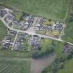
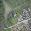
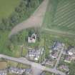
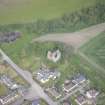
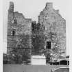
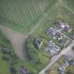
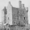
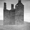
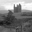
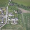
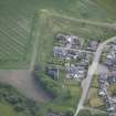
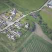
The ruins of Blairfindy Castle, a tower-house, overlook the banks of the River Livet near the modern hamlet of Castleton.
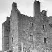
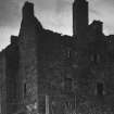
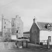
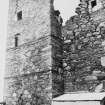
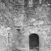
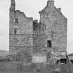
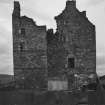
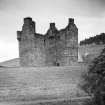
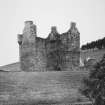
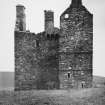
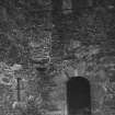
Completed in 1564 by John Gordon, Blairfindy is L-shaped on plan, consisting of a three-storeyed main block and a wing which contains the principal stair to the first floor. An interesting feature is the box machicolation which projects from the wall above the entrance. Such defences were characteristic of medieval castles, where they allowed objects to be dropped down onto attackers during a siege. On a tower-house of this relatively late date, though, the machicolation was a deliberately archaic addition which gave a war-like appearance to what was essentially a residential building.
In 1586, the castle passed to another branch of the Gordon family, when it became a hunting seat of the Earls of Huntly. A datestone set above the entrance was inserted at this time, bearing the initials IG and HG and the family's coat-of-arms.
Text prepared by RCAHMS as part of the Accessing Scotland's Past project
NJ12NE 4 19834 28642
For (predecessor) tower-house of Drumin (NJ 1843 3034), see NJ13SE 2.
(NJ 1983 2862) Castle of Blairfindy (NR) (In Ruins).
OS 6"map, Banffshire, 2nd ed., (1905)
Blairfindy Castle, a hunting seat of the Earls of Huntly, was built in 1586 on the L-plan.
D MacGibbon and T Ross 1887-92.
Blairfindy Castle (MoW plaque), as described and planned by MacGibbon and Ross, is a roofless shell.
Visited by OS (R L) 15 August 1966.
Standing Building Recording (June 2018 - November 2019)
NJ 19838 28646 A historic building survey of a ruined tower house on Crown Estate land at Castleton of Blairfindy, Glenlivet, (Canmore ID: 15970) was conducted in June 2018. It included the creation of measured elevations and plans using a Leica Total Station; a full photographic record in both digital images and black and white film of all external and internal elevations; features of interest; and the wider setting of the building, which was constructed in the 16th century and abandoned by the 19th. The work was carried out in varying but frequently wet and windy conditions. A remotely operated drone was also used to compile a record of the upper levels of the ruin, which were not directly accessible. A watching brief on engineering test pits was conducted on 11 July 2018 and forms the subject of a separate report. Follow-up visits on 28 May 2019 and 19 August 2019, recorded wallhead features and two intra-mural passages, while a watching brief on lightning conductor pits on 25 November 2019, resulted in no new features.
Archive: NRHE (intended)
Funder: Arc Architects Ltd
C Fyles − Alder Archaeology Ltd
(Source: DES Volume 21)
OASIS ID: alderarc1-382461
Watching Brief (24 February 2021)
NJ 19838 28646 Two tumbled stones within the castle entrance were identified as a hazard. The removal of the stones and their relocation elsewhere in the castle was monitored, at the behest of Historic Environment Scotland. The work took place on 24 February 2021. No archaeological deposits or finds resulted.
Archive: NRHE (intended) Funder: Savills Architecture
C Fyles – Alder Archaeology Ltd
(Source: DES Vol 22)
Note (5 July 2022)
The tower house is commonly believed to have been constructed by the Gordon family and served as hunting seat for the earls of Huntly. A datestone set above the entrance bears the date 1586, the initials IG and HG and the family's coat-of-arms. However, it have been suggested that the castle was completed as early 1564 by a John Gordon. In 1647, the 2nd Marquess of Huntly was imprisoned here, one of his own houses, before his trail and execution in Edinburgh in 1649.
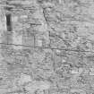
It is situated above the Pass of Livet, historically an important routeway between Bamfshire and Aberdeen shire. It consists of a 4-storey, L-plan tower house built of whin and sandstone random rubble in lime mortar with rough granite dressings. The walls are founded on large boulders just at ground level.
The tower is entered through a round-headed entrance at ground level in the NE re-entrant angle. This has the remains of a boldly corbelled out box machicolation above. The ground floor of the main block had a vaulted kitchen and cellar accessed by a corridor. The cellar has a narrow stair rising up to the hall. The vaulting was intact in the 1890s but has subsequently collapsed. Above was the hall, a second floor chamber and a third floor attic chamber giving access to a corbelled round or bartizan and the box machicolation. The wing or jamb contained a wide staircase to the first floor, with access to the upper floors being by a circular stair corbelled out between the junction of the wing and main block.
D MacGibbon and T Ross 1887-1892; N Tranter 1970
Information from the HES Castle Conservation Register, 5 July 2022
Standing Building Recording
NJ 19838 28646 A historic building survey was undertaken, 13 – 15 June and 11 July 2018, of a ruined towerhouse on Crown Estate land at Castleton of Blairfindy. The survey included the creation of measured elevations and plans using a Leica Total Station and a full photographic record of all external and internal elevations, features of interest and the wider setting of the building, which was constructed in the 16th century and abandoned by the 19th century. A remotely operated drone was also used to compile a record of the upper levels of the ruin, which were not directly accessible.
A watching brief was subsequently conducted on 11 July 2018 during the hand excavation of engineers’ test pits at the castle in advance of consolidation works. The 16th-century castle, which is a scheduled monument (SM105), is a roofless ruin consisting of a rectangular tower house with side stair-tower, which together form an L-shape. The engineers’ test pits were excavated at the base of the castle walls in order to gain an understanding of the underlying deposits and try to establish the reasons why the building had moved, causing serious cracks to develop. In total eight engineers’ test pits were monitored. The work established that the walls have no substantial below-ground foundations, and are mainly set upon what was considered to be a redeposited natural which was not bottomed. Test pits against the castle’s S wall encountered a cobble surface, which was considered to be 19th / 20th-century in date and the floor of lean-to structures set against the castle wall. Stone roofing tiles with nailholes, which may have originally come from the castle roof, were found over the cobble surface.
Archive: NRHE (intended)
Funder: Arc Achitects Ltd
Ray Cachart – Alder Archaeology
(Source: DES Volume 19)

