
Hoy, Quoyness, Greenhill Broch


Broch (Iron Age), Cist(S) (Prehistoric) - (Early Medieval)
Site Name Hoy, Quoyness, Greenhill Broch
Classification Broch (Iron Age), Cist(S) (Prehistoric) - (Early Medieval)
Alternative Name(s) Green Hill Of Quoyness
Canmore ID 1596
Site Number HY20SW 7
NGR HY 25004 02841
Datum OSGB36 - NGR
Permalink http://canmore.org.uk/site/1596


- Council Orkney Islands
- Parish Hoy And Graemsay
- Former Region Orkney Islands Area
- Former District Orkney
- Former County Orkney
HY20SW 7 2500 0284
Not to be confused with ND39SW 1..
(HY 2500 0284) Green Hill (Brough) (NR)
Human Remains found A.D.1812.
OS 6" map, Orkney, 2nd ed., (1903).
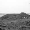
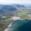
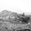
Green Hill is a green mound of stones and earth, evidently that which Sir Walter Scott mentions in 'The Pirate' as the cairn where he landed on his way to the Dwarfie Stane (HY20SW 8). In 1812 men removing the stones for building materials ceased excavating on finding human bones.
Name Book 1880.
About the year 1887 the mound, now 12 to 13 feet high was excavated and revealed the remains at least 20 feet high of a broch. Two or three cists with bones of three bodies but only one skull were found on the top of the mound.
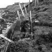
More than half the broch has been eroded by the sea but on the E side are indications of a fairly substantial wall.
(J Cursiter 1923)
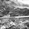
The excavated hollow is now a rubbish pit partly overgrown with vegetation. The site has now an area of roughly 30 yards square.
RCAHMS 1946, visited 13 July 1929.
The grass covered remains of a broch, measuring 25.0 metres E to W by 18.0 metres N To S and 4.0 metres high. In the north side there has been severe mutilation and the excavated hollow is used as a rubbish tip, while in the SW slopes there are traces of walling.
Re-surveyed at 1/2500.
Visited by OS (RD) 16 September 1964.
Field Visit (June 1979)
OS 25 1900 shows Human Remains Found 1812. Confirmed ONB but no details. This map also shows the mound well back from the cliff edge. [R1]
Excavated 1887 by J G Moodie Heddle - on very edge of cliff, remains of broch of which half had disappeared. Average-sized broch 20 ft high. On top were found cists, bones, skull. [R2]
Mound 12-13ft high, site roughly 30yds square, walling visible in banks. [R3]
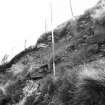
Mr Sinclair found bones identified as human in new exposure at NW side of broch, after severe storm Spring 1979, and reported to the police. Bones are showing on very fringe of mound at depth of 200mm but are clearly sealed with dense-packed rubblerepresenting tumble from broch. Like the 1887 finds these bones
probably represent burials inserted in the ruined broch mound.
Erosion is rapid here; Mr Sinclair reports that the banks fence, which now swings inward over the broch, was in a straight line 15 years ago, representing a loss of 3m of broch site in that time
Information from Orkney SMR (RGL) Jun 79, identified Dr Trickett, Longhope.
Field Visit (June 1979)
Green Hill of Quoyness HY 2500 0284 HY20SW 7
Half of the broch mound at Greenhill farm has now been removed by coastal erosion; it now measures 18m in width and 25m in length along the shore section, standing some 4m high. Finds of cists and burials, apparently
representing post-broch use of the mound, were reported last century, and human bones were recorded in 1979 at the NW fringe of the mound, where a storm had exposed them in dense-packed rubble representing tumble from the broch.
RCAHMS 1989, visited June 1979.
(Name Book, Orkney, No. 10, p. 78; Cursiter 1923, 52; RCAHMS 1946, ii, pp, 108-9, No. 379; OR 105).
Publication Account (2002)
HY20 2 GREEN HILL 2 ('Green Hill of Quoyness')
HY/25000284
Probable broch on the shore in Hoy I., next to Burra Sound, the name of which implies the presence nearby of a recognisable stronghold in Norse times [4, 101]. It is now a green mound of earth and stones which is now 3.7 - 4.0 m (12-13 ft.) high; half of it has now been destroyed by coastal erosion [5]. It seems first to have been disturbed in 1812 when stone was removed to build the nearby house and human bones were found. When it was dug into again in about 1887 by James Cursiter [4] burial cists were found on top of the mound which revealed the remains of a broch at least 6.1 m (20 ft.) high, more than half of which had been eroded by the sea even at that time. Human bones, exposed by erosion, were noted at the North-west corner of the mound in 1979 [5].
Sources: 1. OS card HY 20 SW 7: 2. Cursiter 1923, 49-52: 3. RCAHMS 1946, 2, no. 379, 108-9. 4. Hedges et al. 1987, 101-2. 5. Lamb 1989, 12.
E W MacKie 2002

