
Inverlael, Old Bridge


Road Bridge (Period Unassigned)
Site Name Inverlael, Old Bridge
Classification Road Bridge (Period Unassigned)
Alternative Name(s) River Lael; Loch Broom
Canmore ID 159456
Site Number NH18NE 36
NGR NH 18182 85454
Datum OSGB36 - NGR
Permalink http://canmore.org.uk/site/159456


- Council Highland
- Parish Lochbroom
- Former Region Highland
- Former District Ross And Cromarty
- Former County Ross And Cromarty
NH18NE 36 18182 85454
Inverlael Bridge [NAT]
OS 1:10,560 map, 1971.
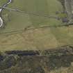
(Location cited as NH 182 854). Bridge, Inverlael, possibly c. 1790. A handsome single segmental rubble arch, with a pronounced hump. Before by-passing, the approaches had been flattened.
J R Hume 1977.
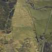
This bridge carries the A835(T) public road over the River Lael to the SE of the southern extremity of Loch Broom.
Information from RCAHMS (RJCM), 11 May 2006.
Build (1792 - 1796)
By 1809 badly decayed, bypassed 1964.
R Paxton and J Shipway, 2007.
Publication Account (2007)
A rubble-masonry humpbacked bridge over the Lael, bypassed in 1964 by the present reinforced-concrete bridge alongside. Its arch is segmental, with roughly shaped arch-rings, spanning 44 ft. The width between parapets is 14 ft. Its probable date of construction was between 1792 and 1796 when the road from Contin to Ullapool was made by Kenneth Mackenzie of Torridon for about £4500 at the expense of the British Fisheries Society to connect with their settlement at Ullapool.
By 1809 the road, which had been made at just over half the cost of surveyor George Brown’s estimate in 1790, was badly decayed and the rebuilding of some bridges was required. But nothing seems to have been done despite a memorial in the late 1830s by local heritors quoting from the New Statistical Account that ‘the line chosen was so bad and absurd, and the execution so wretched, that the road has been for many years back not only useless but dangerous, even to foot passengers and riders on horseback’.
Such is the hump of the old bridge that the underside of its arch at the crown is on the same level as the top of the coping stone of the parapet of the present bridge.
R Paxton and J Shipway, 2007.
Reproduced from 'Civil Engineering heritage: Scotland - Highlands and Islands' with kind permission from Thomas Telford Publishers.

