
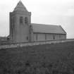
Lossiemouth, Branderburgh, Saint Gerardine's Road, Saint Gerardine's Church


Church (19th Century) (1899), Gate Pier(S) (19th Century) (1899), Wall(S) (19th Century) (1899)
Site Name Lossiemouth, Branderburgh, Saint Gerardine's Road, Saint Gerardine's Church
Classification Church (19th Century) (1899), Gate Pier(S) (19th Century) (1899), Wall(S) (19th Century) (1899)
Alternative Name(s) Prospect Terrace; Saint Gerardine's High Church Of Scotland, Enclosing Walls And Gatepiers
Canmore ID 159226
Site Number NJ27SW 48
NGR NJ 23265 70568
Datum OSGB36 - NGR
Permalink http://canmore.org.uk/site/159226


- Council Moray
- Parish Drainie
- Former Region Grampian
- Former District Moray
- Former County Morayshire
Low, white harled church with solid, short tower and long wing to the west by Sir J Burnet, 1901.
NJ27SW 48 23265 70568
St Gerardine's Church [NAT]
OS (GIS) MasterMap, October 2009.
Location formerly entered as NJ 2327 7057.
Architect: Sir John James Burnet, 1899-1903.
(Undated) information in NMRS.
Photographic Survey (2 May 2013)
Photographed on behalf of the Buildings of Scotland publications 2013-14.

