
Pricing Change
New pricing for orders of material from this site will come into place shortly. Charges for supply of digital images, digitisation on demand, prints and licensing will be altered.
Birnie


Hearth (Period Unassigned), Ring Ditch House (Prehistoric), Roundhouse (Prehistoric), Settlement (Period Unassigned), Smithy (Period Unassigned), Bead (Glass), Brooch(S), Coin Hoard(S), Pot (Iron Age), Whetstone
Site Name Birnie
Classification Hearth (Period Unassigned), Ring Ditch House (Prehistoric), Roundhouse (Prehistoric), Settlement (Period Unassigned), Smithy (Period Unassigned), Bead (Glass), Brooch(S), Coin Hoard(S), Pot (Iron Age), Whetstone
Alternative Name(s) Birnie Kirk; Dykeside
Canmore ID 158983
Site Number NJ25NW 40
NGR NJ 210 585
NGR Description Centred NJ 210 585
Datum OSGB36 - NGR
Permalink http://canmore.org.uk/site/158983


- Council Moray
- Parish Birnie
- Former Region Grampian
- Former District Moray
- Former County Morayshire
NJ25NW 40 centred 210 585
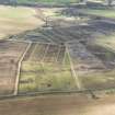
NJ 210 585. In 1996 a number of Roman coins were found by a metal detectorist near Birnie. These were reported and claimed as Treasure Trove, and are now in Elgin Museum. Their date and range suggest that they derived from a scattered hoard of Severan date, part of a series known from eastern Scotland. Aerial photographs of the field reveal cropmarks of later prehistoric roundhouses, and the site has great research potential in investigating the connection between such a hoard and a settlement, and studying whether this was a site of particular status. Fieldwork in 1998 and 1999 has started to address these questions.
In 1998 fieldwork involved fieldwalking and metal detecting to define the extent and dating of the site, resistivity survey and trial trenching. This identified activity from the Neolithic/Bronze Age (including two leaf-shaped arrowheads), later prehistory and the medieval period. Resistivity results were inconclusive but trial trenching demonstrated the good survival of archaeology, including burnt deposits from a building. Fieldwalking in the adjacent Paddock Haugh field, between the site and Birnie Kirk, found very little material. The lack of medieval finds suggests cropmarks recorded in this field may be pre-medieval.
In 1999 the trial trench was followed up with a larger trench opened up to encompass half of one house and a sizeable area around it. This revealed a roundhouse some 15m in diameter with an internal post-ring. The house had burnt down, apparently after the main timbers had been removed. Sondages indicated that the burning had preserved aspects of the internal layout such as slots and turf-built features which normally rarely survive. Finds include a copper-alloy spiral finger ring and what may be part of a sword. A number of undiagnostic features surrounded it. To the N was a sub-rectangular spread identified as a blacksmith's workshop, which pottery suggests is medieval. Around this were pits which may have been used for charcoal burning.
Metal detecting around the site recovered more coins from the hoard (making a total of 28 to date) and two Roman brooches, one of which is earlier than the hoard and indicates more extended contact with the Romans. A radiocarbon date on a charred timber from the house came out at cal AD 80-340 (95%; 1830+/-50 bp, Beta_131629), suggesting the settlement is at least in part contemporary with the hoard.
Sponsor: National Museums of Scotland
F Hunter 1999
NJ 210 585 Continuing excavations in the area of a scattered Roman coin hoard and later prehistoric settlement (NMRS NJ25NW 40; DES 1999, 63) had three main aims: examination of another cropmark feature; study of the area where the scattered coins were found; and examination of the findspots of the two Roman brooches found in 1999. This last provided a negative result: a 5 x 5m trial trench at each point found no underlying archaeology, and the brooches may be off-site deposits, the sole survivors of ploughed-out features, or scattered some distance by the plough from their original context.
A trench, some 26 x 27m, was opened around an amorphous dark area visible on the cropmark with what appeared to be a post-ring to one side. The post-ring proved illusory - it was a broadly circular series of disparate features. However, two ring-groove buildings, c 11.2m and 12.8m diameter, and two post-ring buildings, the rings 4.4m and 9.6m diameter, were located, along with a range of other features. A number of contexts suitable for radiocarbon sampling were excavated.
The amorphous dark patch proved to be a complex area of stratified deposits which had survived the plough. They could only be partly explored in the time available. To the W lay an oval scoop, c 6.6 x 4.8m, comprising a series of charcoal-rich layers and stone surfaces. This is interpreted as the floors of a building with no earthfast structural traces. A Guido class 13 glass bead suggests an Iron Age date; iron objects were also recovered, including a knife fragment and a pruning hook.
To the E a rectangular medieval building, 8.2 x 3.4m, was revealed, but not explored in detail. It was connected with a cobbled stone yard. A blacksmithing hearth lay nearby, but could not be stratigraphically connected and may be linked to underlying Iron Age features. These were only sampled, but comprised scoops with charcoal-rich layers and cobbling, producing Iron Age pottery.
The third strand of research was the study of the area where Roman coins had been recovered in previous seasons. This was believed to represent a ploughed-out hoard. An area, c 15 x 15m, was stripped in spits around the focus of the distribution, with the surface metal-detected after each spit. This revealed a linear scatter of coins, presumably along the line of a plough furrow. A 2 x 2m trench was excavated by hand in the centre of the distribution. At the base of the ploughsoil the remains of the hoard were found, contained in a smashed Iron Age pot. These were lifted in a block. Conservation is still in progress, but it is estimated the hoard contains some 250-350 denarii; the latest coin identified so far is Severan. It seems the pot was ploughed out of the upper fill of an adjacent pit. A wide range of other negative features were found in the area, including the corner of a ring-groove house around 8m in diameter. Some of these were sampled, and it is hoped to examine them more fully in subsequent seasons to clarify the context of the hoard.
A metal-detecting survey produced a range of post-medieval finds and a bridle bit ring which is likely to be Iron Age.
Sponsors: National Museums of Scotland, Society of Antiquaries of Scotland.
F Hunter 2000
NJ 210 585 A further season of excavations in September and October 2001 at this Iron Age settlement site (NMRS NJ25NW 40) had four aims: to test the evidence for a possible palisaded enclosure to the E of the main site; to evaluate more of the cropmarks; to investigate the context of the Roman coin hoard found in 2000; and to continue the metal-detecting survey (see DES 2000, 58-9). A trench (76 x 4m) confirmed that the supposed palisade did not exist, and very few features were noted. A trench to the N of the hoard, 25 x 8m, confirmed an air photo feature as a post-ring 9.2m in diameter with a surviving area of floor deposits in a hollow beyond, giving an overall diameter of some 13m. To the S of the hoard, a trench, 42 x 10m, examined three features visible on the air photo. The northernmost was an area of cobbling associated with quantities of slag; this was not examined in detail and no dating evidence was recovered. The central feature was a ring-groove house, 11.6m in diameter with extensive surviving floor deposits. A section through this recovered dating material and later prehistoric pottery. The southernmost feature was only partly exposed, but appeared to be another house with a charcoal-rich crescent surviving in a ring-ditch feature around 8m diameter. Dating samples were taken and later prehistoric pottery was recovered.
A 30 x 20m trench was opened around and to the W of the area where the 2000 hoard was found. This revealed a substantial and well-preserved roundhouse 16.4m in diameter, with floor deposits surviving over two-thirds of it. A ring-groove was preserved on the W side, and the substantial posts of the doorway were located to the SE. Other features included an extensive cobbled spread and what is probably part of another house.
The most unexpected discovery was a second coin hoard some 8m N of the first one. This survived intact, buried in a globular everted-rim jar in a small pit. The pot was lifted in a block and has not yet been excavated, but it contains several hundred denarii apparently of the late 2nd/early 3rd century AD; organic remains are preserved by the corrosion. The hoard lay beside a post-hole, but a connection cannot yet be demonstrated. The site was swept with a deep-seeking metal detector to ensure there were no further hoards. This discovery of two hoards (or two parts of one hoard) on the one site is unparalleled in Scotland. The proximity of the hoards to the largest house found so far on the site is noteworthy, and suggests it may be of particular status.
A metal-detecting survey recovered a Roman fantail brooch, a ring from a bridle bit which may be the pair to the one found in 2000, and lead spindle whorls and an Edwardian silver penny from the medieval use of the site. Other finds include saddle querns and a yellow glass bead. The range of Iron Age and Roman finds indicates that what looks from the air like any other open settlement was actually a site of considerable status and importance. Excavations are planned to continue in 2002.
Sponsors: National Museums of Scotland, Society of Antiquaries of Scotland, Caledonian Quarry Products, White's Electronics.
F Hunter 2001
NJ 210 585 Further excavation (DES 2001, 67-8) focused on three main areas: exploring the area around the Roman coin hoards; establishing the southern limit of the settlement (NJ25NW 40); and exposing and trial trenching further cropmarks. In addition, further metal detecting was carried out.
A trench 30 x 20m was laid out E of the 2001 hoard trench. This revealed two roundhouses: one a two-phase structure some 8.8m in diameter with a ring-groove and a post-ring phase, the other a more sizeable house, some 12m in diameter with an 8m diameter post-ring; surviving floor deposits overlying this included a hearth and broken rotary quern. One pit adjacent to the 2001 hoard produced an inverted saddle quern; another contained most of a smashed pot. A crucible was also recovered.
A 40m long trench on the southern edge of the plateau located the limit of the settlement; the density of features dropped off dramatically as the ground dipped, although there was no formal boundary. This suggests a settled area of some 150 x 150m. A palisaded enclosure 16.4m in diameter was located on the N edge of the site, heavily truncated by ploughing. There was no sign of any internal structures, and it may have been a stock enclosure. Two other evaluation trenches, one over a cropmark feature and one in an apparently blank area, both uncovered a wealth of features, but they were not explored in detail.
Metal detecting produced a range of finds, notably a small Romano-British enamelled bronze bird. This lay some 150m SE of the main settlement; trial trenching here found the heavily attenuated remains of a shallow ditch, probably a land boundary of uncertain date.
Sponsors: NMS, Society of Antiquaries of Scotland, Ian Keillar, Caledonian Quarry Products.
F Hunter 2002
NJ 210 585 Work continued in September and October 2003 on this Iron Age and later settlement associated with two Roman coin hoards (DES 2002, 81; NJ25NW 40). Four main areas were looked at: fuller examination of one of the roundhouses; sampling of post-Iron Age features; confirmation of the southern limit of the site; and continuing the metal detecting survey.
A roundhouse at the N edge of the site (partly exposed during previous work; DES 2001, 67-8) was fully exposed. It comprised a single-phase post-ring, 8.8m in diameter, with, on the N and W, a crescentic shallow ring-ditch, 3-3.5m wide (overall diameter c 16m). A central cooking pit showed multiple phases of use, with a flue attached in one phase. Surviving deposits in the E of the house may represent floor deposits, but could not be examined in the time available. The house is actively being damaged by ploughing.
Excavation of features overlying one of the roundhouses examined in 2002 was completed. These comprised a hearth and series of pits with fire-cracked stone, perhaps within a rectangular structure. Two elongated features visible on the aerial photo were sampled. One had been partly examined in 2002: sectioning showed that it was a sub-rectangular hollow with a central hearth, the hollow developing between the post rows of a rectilinear structure. No datable artefacts were recovered, but it is assumed to be Early Historic or medieval. The second feature proved to be of similar character. Spatially these are probably connected to the medieval smiddy previously excavated (DES 1999, 63).
Metal detecting in 2002 produced a medieval pilgrim's badge from the southern edge of the gravel terrace. A trial trench here (12 x 12m) found few features, confirming the boundaries of the settlement as suggested from previous work. The metal detecting survey found little beyond a stray denarius from the first hoard.
Sponsors: NMS, Ian Keillar, Caledonian Quarry Products.
F Hunter 2003
NJ 210 585 The second phase of investigations of the Iron Age and medieval site at Birnie started in August 2004. Following the results of the initial evaluation work (DES 2003, 96), funding has been secured for four seasons of larger-scale fieldwork to explore the context of the Roman coin hoards. The aim is to investigate at least one well-preserved roundhouse and one of the medieval structures each year.
In 2004 three trenches were opened. The first (N) continued the investigation of the ring-ditch house exposed in 2003. Two main phases of deposits in the ring-ditch were identified, both apparently intended to consolidate the eroding floor surface. Evidence of trampling in the uppermost suggests the stalling of animals. An extension of this trench to the SW exposed an extensive spread of charcoal-rich deposits from a hitherto unsuspected structure.
To the S, trench M exposed more of a roundhouse first sampled in 2001 (DES 2001, 67-8). This was of ring-groove construction,
c 11.6m in diameter, with an entrance towards the E. The ring-groove appeared to give way to a post-built wall in the eastern arc around the door, suggesting the entrance was more massively and impressively constructed. Overlying deposits relate to the abandonment of the building, as they covered the internal post ring. Rather than a ring-ditch, a series of hollows between the posts was revealed, suggesting a series of individual compartments.
A central cooking pit produced a clay mould for a disc-ingot, while a cattle skull had been buried in the upper fills. A similar skull was also found in the infill of the southern door post-pit. To the N of the house was a cobbled surface which included substantial lumps of smelting slag. Trampled into the surface was an unusual Roman enamelled tapering-bow brooch decorated with a series of applied knobs. From the topsoil came a plain copper-alloy terret, the first of its type from the area.
A putative medieval sub-rectangular scooped feature was examined in trench P (see DES 2003, 96). This represents the sunken floor (c 5.8 x 3m) of a two-phase structure. In the first phase it had a central pit; in the second the hollow was infilled to create a more level surface and a new cooking pit was dug outwith the hollow, filled with burnt stone and animal bone. Traces of the superstructure were sparse, but four irregularly placed post-holes may be related. No artefactual evidence was recovered, but samples were taken for dating. To the N, an extensive area of charcoal-rich deposits was revealed, with two small saddle querns in the surface. To one side an oval pit with a surface scatter of slag and fired clay is likely to have been an ironworking furnace, but was not examined in detail this season.
To the SW of the site, on the terrace edge overlooking Birnie Kirk, lies a small sand quarry. Inspection of this revealed an eroding drystone structure, which proved to be a corn-drying kiln of medieval or later date (as it was cut through a layer with medieval pottery). It is noticeable that the medieval features on the site cluster near this terrace edge, towards the church, while the later prehistoric ones are more widely spread over the plateau. Metal detecting finds include a medieval silver penny.
Sponsors: HS, NMS, Ian Keillar, Moray Field Club, Caledonian Quarry Products.
F Hunter 2004
Late Bronze Age metalworking area; (NMS) later prehistoric and medieval settlement NJ 210 585 Work continued in August and September 2005 on the later prehistoric site at Birnie (NJ25NW 40; DES 2004, 84-5) with the aim of disentangling the evolution of the settlement. Two roundhouses were investigated. The main trench exposed all of the
house first sampled in 1999 (DES 1999, 63), which produced a Roman Iron Age radiocarbon date. The house, 16m in diameter, had burnt down and was very well preserved. Its whole extent was exposed, with an entrance to the SE, central hearth and inner post-ring. Preservation was best to the rear of the building where there was a ring-ditch, with only shallow surviving deposits in its southern third. In the W half of the building the destruction deposits were
studied. A charcoal-rich layer with remains of burnt turfs from the roof and substantial charred timber fragments was examined in part; much further work remains for next year. In the E half, the overlying contexts (burnt deposits damaged by pre-modern ploughing) were removed. From these came a number of yellow glass beads and a sherd of Roman coarse ware (BB2). Other notable finds include a fragment of cannel coal pendant and an unfinished bead, both
unstratified. These are the first such finds from the site, and point to connections across the Moray Firth, as the nearest source of raw materials is at Golspie.
Another structure previously examined in 2000 was fully exposed (DES 2000, 58-9). It lies on a slight slope at the W edge of the site, and any internal features had been entirely removed by ploughing. However, three phases of enclosing ring-groove, 13m in diameter, were revealed, with an entrance to the E. It was probably a house rather than a small enclosure.
One of the putative medieval sub-rectangular features seen on aerial photographs was also examined. This proved to be the sunken floor of a two-phase structure, lacking earthfast foundations. The hollow appears to have been deliberately created rather than eroded, with two phases of flooring, the uppermost cobbled. There were no medieval finds: all the datable objects are later prehistoric (bar a flint arrowhead), suggesting a Late Iron Age date or (given the shape of the building) perhaps Pictish; radiocarbon dates should clarify this.
A speculative trench on the W of the site, where the site cabins are normally located, uncovered a Late Bronze Age metalworking area. This was characterised by a series of pits and post-holes containing plentiful fragments of clay crucibles and moulds: axe, pin and bangle moulds can be identified. One pit contained the charred remains of a large oak item, probably a charred tree trunk which may have been used as an anvil. In another pit, saddle quern and rubber
fragments had been deposited, apparently purposefully.
Further metal detecting produced two more Roman denarii from the first hoard.
Sponsors: HS A, NMS, Ian Keillar.
F Hunter 2005
In 2006 work at Birnie focussed on four main trenches. Good progress was made with the burnt-down roundhouse - the layers are complex, interleaved and varied, but they tell fascinating stories. Many of them derive from burnt turf, and it seems both walls and roof were turf-built, with collapsed wattle revetting from the inner wall face found at the base of the deposits. In places some possible floor deposits survived, but there is little sign of occupation debris. As a result, finds were sparse but choice - notably the terminal of a gold ribbon torc and an exotic amber bead, confirming the site's status.
The late Bronze Age metalworking area located in 2005 was explored more throughly. There is no substantial workshop structure, and the activity was quite ephemeral. Two curved slots are probably temporary shelters or wind breaks. Along with mould fragments for pins, bangles and axes was debris from spearheads and perhaps swords. This will be a key assemblage for this period.
To the north-east, a possible iron-working area first seen in 2004 was examined. This revealed a well-preserved iron-smelting furnace complex, with stone foundations and a clay superstructure. It had met a catastrophic end, with the clay walls collapsing. A shallow horseshoe-shaped erosion gully aligned on the furnace probably arises from associated activity. In the south-west of the trench, a four-post structure was found, probably a typically Iron Age grain storage building.
Towards the north-west corner of the site, a large trench was opened over the remains of a possible medieval building exposed in 2000. This proved hard to trace, but a massive later prehistoric ring-ditch house was found. Within the house are a pair of clay iron-smelting furnaces, though they may not be contemporary with the building. There is also a rash of earlier activity, its nature still unclear.
Important finds included the moulds, the gold torc fragment and the amber bead noted above, which all confirm the inhabitants' status, while a fragmentary brooch-pin form metal-detecting is the first secure Pictish evidence from the site.
F Hunter 2007
Excavation (August 2007 - September 2007)
NJ 210 585 Work continued on the later prehistoric site at Birnie (DES 2006, 109) in August-September 2007, with four trenches being examined. Ongoing excavation of the burnt-down roundhouse revealed extensive remains of charred timbers from the wall, roof and possibly an upper floor. Substantial structural posts were also found, some squared, and other structural elements including a mortice and tenon joint. Finds included a
range of glass beads (including a Guido type 13 and an unusual biconical blue one), a rotary quern stone and a series of stone tools. The bulk of the destruction deposits in the western half have now been excavated, revealing the ring groove of an earlier and smaller house on a slightly different alignment. The SE quadrant was also examined, with removal of much less extensive destruction deposits revealing a series of large pits and an oval stone feature, yet to be excavated. In the NE quadrant, further cleaning revealed hints of an overlying rectangular structure defined by slight cobbled spreads. Continued excavation of the large ring-ditch house examined in 2000 and 2006 revealed a series of rebuilds, with evidence of at least four structures around 19m in diameter on the same site. Most had E entrances, but at one stage there was a NW entrance. There were no surviving floor deposits, but finds from the feature fills suggest a later Iron Age date. The pair of ironsmelting furnaces found in 2005 were demonstrated to post-date the house. They may be connected with other later features, including a paved arc and a series of post-sockets, perhaps of medieval date. The third trench examined the area where the coin hoards came from (DES 2000, 58–9; 2001, 67–8). This confirmed that there were no structures connected with the hoards, and revealed two other unusual deposits: a pit with a high-quality barely-used whetstone at its base, and another pit with an intact inverted globular everted-rim Iron Age pot. Unusually for the area, this had a decorative cordon round its neck. These and previous finds support the notion that this area was a focus for votive offerings. The final trench, to the SW of previously excavated areas, produced very few features, confirming the limits of the site in this direction.
Funder: National Museums Scotland, Historic Scotland, Ian Keillar, Moray Society, Moray Field Club, RCAHMS.
Excavation (17 August 2008 - 12 September 2008)
NJ 210 585 Excavations continued at the multi-period settlement site of Birnie (see DES 2007, 131), with four trenches being opened from 17 August–12 September 2008. Work continued on the burnt down roundhouse, with some two-thirds of the house now fully excavated. The extent of the smaller underlying ring groove house is now clear. The overlying large ring ditch house had been heavily used and repaired by the time it burnt down. The ring ditch had eroded around several postholes while others had been replaced, in one case with an overlying area of stone packing, perhaps acting as a post base. A series of stone roof weights which had collapsed during the fire were recovered, as were substantial fragments of charcoal. Finds from the house included a fragment of a Type 1 glass bangle which showed evidence of repair. Soon after the fire a cobbled surface was laid over the remains. Further investigation in the area of the coin hoards confirmed that another house lay immediately to their W. This was overlain by a spread of material which included cobbled areas, burnt clay layers and a spread of substantial charred wood fragments. This suggests that an industrial area, its date as yet unclear, may lie beyond the trench edge. To the SW among an extensive range of features was a small post ring some 3.4m in diameter.
Between this trench and the burnt house another substantial ring ditch house was investigated; this was known from cropmarks but previously untouched. It was a large single phase structure, some 16m in diameter,
with a ring ditch round the northern half and a series of shallow erosion hollows in the peripheral space of the southern half. Internal features included a massive near central posthole, an internal partition preventing direct access into the ring ditch from the door, and a linear slot which appears to post-date the house. On abandonment, burnt material was dumped in the ring ditch and a series of pits were dug across the doorway. Overlying it were the remains of a sub-rectangular Pictish building, its foundations represented only by two shallow postholes. Linked to this were a cobbled area, a hearth and associated pit, dated by an Early Historic gold-and-glass bead. The fragile remains only survived through slumping into the underlying roundhouse. Finds from this trench included a painted pebble (the first from the area), a small dagger in its sheath and a small spherical glass playing piece/pin head decorated with inlaid spirals.
A final trench to the E of the burnt house confirmed that remains noted in 2001 at the southern end of trench M comprised a further roundhouse.
A metal detecting survey produced a Romano-British zoomorphic namelled brooch, several more denarii from the scattered hoard and a button-and-loop fastener.
Funder: National Museums Scotland, Historic Scotland, Ian Keillar, Moray Field Club and RAF Lossiemouth
Fraser Hunter (National Museums Scotland), 2008
Excavation (August 2009 - September 2009)
NJ 210 585 In August–September 2009 continuing excavations (DES 2008, 122–3 with further references) focused on four main trenches. The bulk of destruction deposits in the NE quadrant of the well preserved burnt-down roundhouse were excavated, with considerable quantities of well preserved charred remains. To the E, full exposure of a cropmark feature partly excavated previously (DES 2001, 67) revealed it was a ring ditch house some 12m in diameter which had also burnt down, with well preserved timbers in the ring ditch. Among the destruction deposits was a Fowler type A3 penannular brooch and part of a Guido 13 glass bead. The house was single-phase. Post-abandonment activity was attested by a stone-built hearth, although no convincing signs of a connected building could be detected. A roundhouse partly explored in 2000 (DES 2000, 59) was fully exposed. Unusually it had two entrances. The ring groove, 11.6m in diameter, must have held the structural weight of the building, as there was no post-ring. To the N, remains first seen in 2004 were shown to be a substantial two-phase ring ditch house, a maximum of 15.6m in diameter. Again this had burnt down, with remarkably good preservation of large charred timbers in structural relationship surviving just below the topsoil. Further work is planned to explore this feature. To its E lay a much smaller post-ring house, the ring some 5.6m in diameter. Adjacent to this, examination was completed of the central features of a house excavated previously (DES 2004, 84). Two further trenches confirmed that the density of remains falls off dramatically to the E.
Funder: NMS, Historic Scotland, Moray Field Club, RAF Lossiemouth and Lord Doune
Fraser Hunter – National Museums Scotland
Excavation (22 August 2010 - 18 September 2010)
NJ 210 585 The final season of large-scale excavations undertaken 22 August–18 September 2010 at the later prehistoric settlement Birnie (DES 2009, 122 with further references) completed the excavation of the burnt-down roundhouse (trench D). There were few features in the central area apart from a substantial two-phase cooking pit; this NE area of the building had not seen the same extensive secondary activity prior to destruction as the adjacent area to the S. Further examination of the trench AL roundhouse (DES 2009, 122) clarified the sequence. Two houses were present. The earlier (c14m in diameter) had no ring ditch, with its wall defined by a ring-groove round the N half of the building only; clear terminals show this was its original extent, not the result of later damage. The later building (c15.6m diameter) lacked evidence of a wall, but was
associated with a ring ditch. It had a double-leaf door; a slot across the northern half suggests this was normally closed, perhaps with a wicket gate set into it. Further excavation of the ring ditch showed that the turf wall had collapsed inwards, presumably from dereliction, before the building was burnt down; additional well preserved structural components, probably from the roof, were excavated. The post-abandonment deposits preserved in the house hollow included a large amount of Iron Age pottery. This building complex cut a smaller, earlier post-ring (6m diameter) to its NW. A clay-filled pit in this area was probably a store of raw material.
Trench AH (DES 2008, 123) was partly reopened to clarify aspects of the roundhouse sequence. Further excavation of the ring ditch showed that the house had clearly burnt down, with in situ structural charcoal. Post-house activity included a layer of cobbling deposited in the N terminal; a pit cut through the destruction deposits produced a steatite spindle whorl. This activity probably relates to the Pictish building immediately to the S. The trench was expanded to the W. This proved relatively sterile, but a shallow oval scoop (c9.0 x 3.3m) is interpreted as the eroded floor of a building. It overlay a shallow gully, perhaps an earlier structural element
of the building. Finds were sparse, although a single Guido class 13 bead provides a Late Iron Age terminus post quem for its infill. It cut a massive multi-phase sand-filled pit of uncertain date and function. Two similar buildings defined by erosion scoops were identified; such structures have been found in previous years, and interpreted as Pictish or medieval. Trench AW, a long N–S trench designed to test a previously unexamined
area between trenches D and M, located a very shallow charcoal-rich oval scoop 7.0 x 2.5m. This had no earthfast structural elements; surviving charcoal suggests a plankbuilt component. The known scoop in trench V (DES 2003, 96) was fully exposed and excavated. This proved to be a rather
deeper oval scoop, probably associated with a curving line of small posts on its S side. Heavy wear of the floor led to material being dumped to build up the surface, and cobbling being laid at the W end. This was probably the
entrance, as a shallow erosion hollow defined a path to another feature, unfortunately it was inaccessible as it lay under an electricity pole. The only find from the scoop was a crucible fragment. Trench AT was placed on the NW edge of the site, to examine enigmatic remains noted on the margins of previous trenches. It produced an extensive irregular cobbled spread, interpreted as levelling of an uneven area; no structural elements were found, but it overlay some of the features in the area. Few of these formed coherent patterns, and they clearly represent some time depth; some produced sherds of Early Neolithic pottery, another had a saddle quern and rubber buried in the base. In the NW corner, two previously
unknown overlapping post-ring roundhouses were located, the post-rings 5.5 and 9.2m in diameter. Two further trenches were excavated. Trench AV, to the SE of the known concentration of material, confirmed the main
activity did not spread along a low ridge in this area. Trench AU lay immediately N of the Late Bronze Age metalworking area examined previously (DES 2005, 94); there was no sign that this extended further to the N. Finds from excavation and metal detecting included two further stray denarii from the first hoard; the first Roman bronze coin from the site (a Flavian as); two sherds of Roman coarse ware (study of the 2009 pottery revealed a sherd of samian ware as well); a wide range of Iron Age pottery; several crucible fragments; a range of glass beads and, more unusually, an amber bead. Earlier prehistoric activity was uncharacteristically common; most striking was a polished stone axe found in an isolated pit in trench AH. Reports: Can be accessed by typing ‘birnie’ into the search
engine at http://repository.nms.ac.uk/
Funder: National Museums Scotland, Historic Scotland, Moray
Field Club and University of Cardiff
Excavation (8 May 2011 - 22 May 2011)
NJ 210 585 Small-scale excavation was undertaken at the later prehistoric settlement of Birnie (DES 2010, 108–9 with further references) to clarify loose ends from the long-running excavations; a rather larger scale evaluation exercise took place to the S of the main site in advance of renewed agricultural work. This work was carried out between 17–28 April and 8–22 May 2011.
Further work in parts of the trench AL roundhouse (DES 2010, 109) clarified the nature of late activity within the abandoned house, with the discovery of a hearth full of hammerscale from blacksmithing; an intact iron fire-shovel was found in an adjacent pit. The interior of the trench AH roundhouse (DES 2010, 109) was re-examined to clarify its construction; the structural post-ring was successfully identified, along with evidence of earlier and later activity on this stance.
An area immediately to the S of the known site was examined in advance of intensified agricultural activity (trench AX). The results showed that ancient activity had stretched beyond the higher parts of the sandy terrace into this area. A thin scatter of features was revealed and the majority sampled. Key features included a small post-ring roundhouse (the post-ring 6.0m in diameter), another blacksmith’s pit full of hammerscale, an unlined corn-drying kiln with a stone baffle wall between bowl and flue, and a segmented shallow ditch. This ran beyond the trench edge, but was overlain in one area by a large stone, 1.6m long. Immediately S of this lay a stone-packed hole, probably for the recumbent stone, and indicating it was once a standing stone – an unexpected find in an area which has seen such extensive agricultural improvement.
Reports: Can be accessed by typing ‘birnie’ into the search engine at http://repository.nms.ac.uk/
Funder: National Museums Scotland
National Museums Scotland, 2011

