
Pricing Change
New pricing for orders of material from this site will come into place shortly. Charges for supply of digital images, digitisation on demand, prints and licensing will be altered.
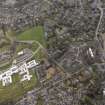
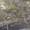
Perth, Gowrie Street, Potterhill


Slab Block (20th Century)
Site Name Perth, Gowrie Street, Potterhill
Classification Slab Block (20th Century)
Alternative Name(s) Perth, 1 - 48 Potterhill
Canmore ID 158876
Site Number NO12SW 494
NGR NO 12357 23886
Datum OSGB36 - NGR
Permalink http://canmore.org.uk/site/158876


- Council Perth And Kinross
- Parish Kinnoull
- Former Region Tayside
- Former District Perth And Kinross
- Former County Perthshire
Commission And Contract (16 November 1961)
A slab block with private balconies built as public housing by Perth Borough Council. The block contains 48 dwellings in total. The contractors for the development were Wimpey. Construction was approved by committee in 1961.
Glendinning and Methusius 1994
Photographic Record (February 1983)
Photo taken by Dr Miles Glendinning for research purposes.

