
Luing, Blackmillbay, Pier


Pier (19th Century) - (20th Century)
Site Name Luing, Blackmillbay, Pier
Classification Pier (19th Century) - (20th Century)
Canmore ID 158611
Site Number NM70NW 34
NGR NM 73185 08353
Datum OSGB36 - NGR
Permalink http://canmore.org.uk/site/158611


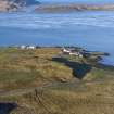


- Council Argyll And Bute
- Parish Kilbrandon And Kilchattan
- Former Region Strathclyde
- Former District Argyll And Bute
- Former County Argyll
NM70NW 34.00 7318 0835.
NM70NW 34.01 7321 0835 Luing, Blackmillbay, Pier, Shelter

