
Pricing Change
New pricing for orders of material from this site will come into place shortly. Charges for supply of digital images, digitisation on demand, prints and licensing will be altered.
Upcoming Maintenance
Please be advised that this website will undergo scheduled maintenance on the following dates:
Thursday, 30 January: 11:00 AM - 3:00 PM
During these times, some functionality such as image purchasing may be temporarily unavailable. We apologise for any inconvenience this may cause.
Berryley


Henge (Neolithic) - (Bronze Age)(Possible), Pit(S) (Period Unassigned), Pit Circle (Prehistoric)(Possible), Ring Ditch (Period Unassigned), Timber Circle (Neolithic) - (Bronze Age)(Possible)
Site Name Berryley
Classification Henge (Neolithic) - (Bronze Age)(Possible), Pit(S) (Period Unassigned), Pit Circle (Prehistoric)(Possible), Ring Ditch (Period Unassigned), Timber Circle (Neolithic) - (Bronze Age)(Possible)
Canmore ID 15853
Site Number NJ05NW 71
NGR NJ 00200 56561
Datum OSGB36 - NGR
Permalink http://canmore.org.uk/site/15853


- Council Moray
- Parish Edinkillie (Moray)
- Former Region Grampian
- Former District Moray
- Former County Morayshire
NJ05NW 71 0021 5654
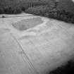
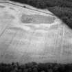
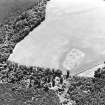
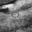
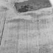
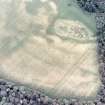
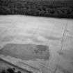
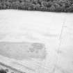
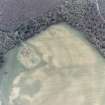
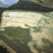
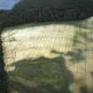
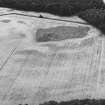
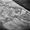
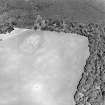
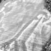
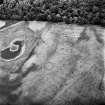
Air photography (imagery cited in MS/712/19) has recorded the cropmark of a ring-ditch on a very gentle slope at an altitude of 35m OD.
NMRS, MS/712/17 and MS/712/19.
Aerial Photographic Interpretation (16 December 2013)
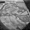
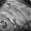
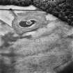
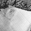
A ring ditch, possibly a henge, and what may be a pit circle have been recorded as cropmarks on oblique aerial photographs (RCAHMSAP 1976, 1981, 1982, 1992; CUCAP 1981; AAS 1978, 1982) some 460m NE of Berryley. The possible henge measures about 17m in diameter within a ditch 1m wide which is interrupted by an entrance on the SE. A large pit at the centre of the henge and at least four indistinct pits may represent the remains of a pit or timber circle. A scatter of pits extends across the adjacent area.
Information from RCAHMS (KMM) 16 December 2013

