
Pricing Change
New pricing for orders of material from this site will come into place shortly. Charges for supply of digital images, digitisation on demand, prints and licensing will be altered.
Burn Of Keenie


Building(S) (Post Medieval), Enclosure(S) (Post Medieval), Field System (Post Medieval), Rig And Furrow (Medieval) - (Post Medieval), Township (Post Medieval)
Site Name Burn Of Keenie
Classification Building(S) (Post Medieval), Enclosure(S) (Post Medieval), Field System (Post Medieval), Rig And Furrow (Medieval) - (Post Medieval), Township (Post Medieval)
Alternative Name(s) Glen Esk
Canmore ID 158333
Site Number NO57NW 27
NGR NO 5125 7670
NGR Description Centred NO 5125 7670
Datum OSGB36 - NGR
Permalink http://canmore.org.uk/site/158333


- Council Angus
- Parish Lochlee
- Former Region Tayside
- Former District Angus
- Former County Angus
NO57NW 27 centred 5125 7670
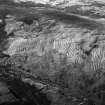
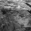
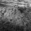
A township, comprising one roofed building, nine unroofed buildings, five enclosures and a field-system is depicted on the 1st edition of the OS 6-inch map (Forfarshire 1865, sheet xiii). Ten unroofed buildings, six enclosures and the field-system are shown on the current edition of the OS 1:10000 map (1976).
Information from RCAHMS (AKK) 30 June 1999.
(GRC/AAS NO57NW 23: name cited as Burn of Keenie and location as NO 5145 7673). Air photography (AAS/01/1/G2/5-6 and AAS/01/1/CT/17-18, flown 13 February 2001) has recorded five irregular-shaped enclosures on a gentle slope at an altitude of 270m OD. They fan out from the SW and all contain rigs.
(GRC/AAS NO57NW 24: name cited as Burn of Keenie and location as NO 5115 7676). Air photography (AAS/01/1/G2/5-6 and AAS/01/1/CT/17-18, flown 13 February 2001) has recorded the remains of three enclosures with attached buildings on a slight spur above the Burn of Keenie, and at an altitude of 285m OD.
(GRC/AAS NO57NW 30: name cited as Burn of Keenie and location as NO 5143 7649). The incomplete remains of several small enclosures and buildings lie scatted along the slope above the N bank of the Burn of Keenie at an altitude of 250m OD.
(Extent indicated on attached GIS plots).
NMRS, MS/712/102.
The following sites were recorded during winter aerial reconnaissance. Details of each site have been deposited in the NMRS.
NO 511 767 Remains of three enclosures, with attached buildings, on slight spur on slope above Burn of Keenie, on S side of Glen Esk.
NO 514 767 Five irregular-shaped attached enclosures containing rigs.
Sponsors: Aberdeenshire Council, Angus Council, RCAHMS
M Greig 2001f

