
Following the launch of trove.scot in February 2025 we are now planning the retiral of some of our webservices. Canmore will be switched off on 24th June 2025. Information about the closure can be found on the HES website: Retiral of HES web services | Historic Environment Scotland
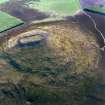
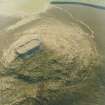
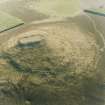
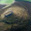
Tap O' Noth


Sheepfold (Period Unassigned)
Site Name Tap O' Noth
Classification Sheepfold (Period Unassigned)
Canmore ID 158115
Site Number NJ42NE 173
NGR NJ 4809 2923
Datum OSGB36 - NGR
Permalink http://canmore.org.uk/site/158115


- Council Aberdeenshire
- Parish Rhynie
- Former Region Grampian
- Former District Gordon
- Former County Aberdeenshire
NJ42NE 173 4809 2923
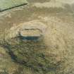
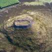
This drystone sheepfold is situated at the break of slope on the SW flank of Tap o' Noth and measures 8.5m square within a wall 1.2m in thickness and up to 1.4m in height. There is an entrance at the WSW end of the SSE side.
The sheepfold is depicted on both the 1st and 2nd editions of the OS 6-inch map (Aberdeenshire, 1870, sheet xlii; 1902, sheet xlii.NE).
Visited by RCAHMS (JRS), 27 November 2002.

