|
Manuscripts |
MS 307/271 |
|
Statistical Account.
Agricultural Survey. |
|
Item Level |
|
 |
On-line Digital Images |
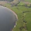
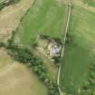
DP 057287 |
RCAHMS Aerial Photography Digital |
General oblique view looking towards Kingarth, taken from the E. |
31/10/2008 |
Item Level |
|
 |
On-line Digital Images |
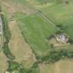
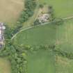
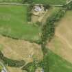
DP 091385 |
RCAHMS Aerial Photography Digital |
Oblique aerial view of Kingarth centred on the parchmarks of the possible long cists and the field boundaries, taken from the ESE. |
21/6/2010 |
Item Level |
|
 |
On-line Digital Images |
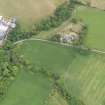
DP 091386 |
RCAHMS Aerial Photography Digital |
Oblique aerial view of Kingarth centred on the parchmarks of the possible long cists and the field boundaries, taken from the E. |
21/6/2010 |
Item Level |
|
 |
On-line Digital Images |
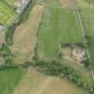
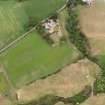
DP 091387 |
RCAHMS Aerial Photography Digital |
Oblique aerial view centred on the cropmark of the enclosure, taken from the N. |
21/6/2010 |
Item Level |
|
 |
On-line Digital Images |
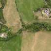
DP 091388 |
RCAHMS Aerial Photography Digital |
Oblique aerial view centred on the cropmark of the enclosure, taken from the N. |
21/6/2010 |
Item Level |
|
 |
On-line Digital Images |
DP 091389 |
RCAHMS Aerial Photography Digital |
Oblique aerial view centred on the cropmark of the enclosure, taken from the NW. |
21/6/2010 |
Item Level |
|
 |
On-line Digital Images |
DP 091390 |
RCAHMS Aerial Photography Digital |
Oblique aerial view of Kingarth centred on the parchmarks of the possible long cists and the field boundaries, taken from the SSW. |
21/6/2010 |
Item Level |
|
 |
On-line Digital Images |
DP 091392 |
RCAHMS Aerial Photography Digital |
Oblique aerial view of Kingarth centred on the parchmarks of the possible long cists and the field boundaries, taken from the E. |
21/6/2010 |
Item Level |
|
 |
On-line Digital Images |
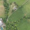
DP 091564 |
RCAHMS Aerial Photography Digital |
Oblique aerial view centred on the parchmarks of the possible long cist cemetery and the field boundaries and the cropmarks of the enclosure, taken from the E. |
21/6/2010 |
Item Level |
|
 |
On-line Digital Images |
DP 091565 |
RCAHMS Aerial Photography Digital |
Oblique aerial view centred on the parchmarks of the possible long cist cemetery and the field boundaries, taken from the SSE. |
21/6/2010 |
Item Level |
|


