
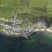
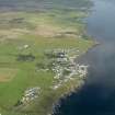
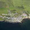
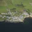
Islay, Port Charlotte, Pier


Pier (Period Unassigned)
Site Name Islay, Port Charlotte, Pier
Classification Pier (Period Unassigned)
Alternative Name(s) Loch Indaal
Canmore ID 157720
Site Number NR25NE 27
NGR NR 2538 5827
Datum OSGB36 - NGR
Permalink http://canmore.org.uk/site/157720


- Council Argyll And Bute
- Parish Kilchoman
- Former Region Strathclyde
- Former District Argyll And Bute
- Former County Argyll

