
Following the launch of trove.scot in February 2025 we are now planning the retiral of some of our webservices. Canmore will be switched off on 24th June 2025. Information about the closure can be found on the HES website: Retiral of HES web services | Historic Environment Scotland
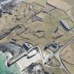
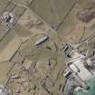
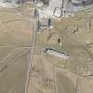
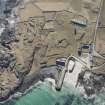
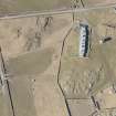
Tiree, Hynish, Lighthouse Shore Establishment, Lower Square Courtyard Buildings


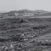
Lighthouse Shore Station (19th Century)
Site Name Tiree, Hynish, Lighthouse Shore Establishment, Lower Square Courtyard Buildings
Classification Lighthouse Shore Station (19th Century)
Alternative Name(s) Old Barracks
Canmore ID 157427
Site Number NL93NE 8.02
NGR NL 98541 39266
NGR Description Centred on NL 98541 39266
Datum OSGB36 - NGR
Permalink http://canmore.org.uk/site/157427


- Council Argyll And Bute
- Parish Tiree
- Former Region Strathclyde
- Former District Argyll And Bute
- Former County Argyll

