|
Manuscripts |
MS 712/91 |
Records of Aberdeenshire Archaeology Service, Aberdeen, Scotland |
Photocopies of updated Aberdeenshire and Moray Planning and Development Services (formerly Aberdeenshire Archaeological Service) archaeological site index record sheets, received January 2000. (Includes Angus material and GIS extracts indicating extents of some sites). |
1/2000 |
Item Level |
|
|
Photographs and Off-line Digital Images |
D 28463 |
RCAHMS Aerial Photography |
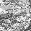
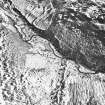
Oblique aerial view of Toardy Burn and Trusty Burn centred on the remains of a farmstead, enclosures, field system, rig and head-dyke, with the remains of a farmstead and the remains of several groups of shieling-huts adjacent, taken from the WNW. |
11/3/1998 |
Item Level |
|
|
Photographs and Off-line Digital Images |
D 28464 |
RCAHMS Aerial Photography |
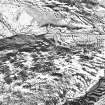
Oblique aerial view of Toardy Burn and Trusty Burn centred on the remains of a farmstead, enclosures, field system, rig and head-dyke, with the remains of a farmstead and the remains of several groups of shieling-huts adjacent, taken from the W. |
11/3/1998 |
Item Level |
|
|
Photographs and Off-line Digital Images |
D 28465 |
RCAHMS Aerial Photography |
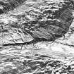
Oblique aerial view of Toardy Burn and Trusty Burn centred on the remains of a farmstead, enclosures, field system, rig and head-dyke, with the remains of a farmstead and the remains of several groups of shieling-huts adjacent, taken from the ESE. |
11/3/1998 |
Item Level |
|
|
Photographs and Off-line Digital Images |
D 28466 |
RCAHMS Aerial Photography |
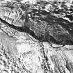
Oblique aerial view of Toardy Burn and Trusty Burn centred on the remains of a farmstead, enclosures, field system, rig and head-dyke, with the remains of several groups of shieling-huts adjacent, taken from the NE. |
11/3/1998 |
Item Level |
|
|
Photographs and Off-line Digital Images |
D 28467 |
RCAHMS Aerial Photography |
Oblique aerial view of Toardy Burn and Trusty Burn centred on the remains of a farmstead, enclosures, field system, rig and head-dyke, with the remains of several groups of shieling-huts adjacent, taken from the NNE. |
11/3/1998 |
Item Level |
|
 |
On-line Digital Images |
SC 1718820 |
RCAHMS Aerial Photography |
Oblique aerial view of Toardy Burn and Trusty Burn centred on the remains of a farmstead, enclosures, field system, rig and head-dyke, with the remains of a farmstead and the remains of several groups of shieling-huts adjacent, taken from the WNW. |
11/3/1998 |
Item Level |
|
 |
On-line Digital Images |
SC 1718821 |
RCAHMS Aerial Photography |
Oblique aerial view of Toardy Burn and Trusty Burn centred on the remains of a farmstead, enclosures, field system, rig and head-dyke, with the remains of a farmstead and the remains of several groups of shieling-huts adjacent, taken from the W. |
11/3/1998 |
Item Level |
|
 |
On-line Digital Images |
SC 1718822 |
RCAHMS Aerial Photography |
Oblique aerial view of Toardy Burn and Trusty Burn centred on the remains of a farmstead, enclosures, field system, rig and head-dyke, with the remains of a farmstead and the remains of several groups of shieling-huts adjacent, taken from the ESE. |
11/3/1998 |
Item Level |
|
 |
On-line Digital Images |
SC 1718823 |
RCAHMS Aerial Photography |
Oblique aerial view of Toardy Burn and Trusty Burn centred on the remains of a farmstead, enclosures, field system, rig and head-dyke, with the remains of several groups of shieling-huts adjacent, taken from the NE. |
11/3/1998 |
Item Level |
|
 |
On-line Digital Images |
SC 1718824 |
RCAHMS Aerial Photography |
Oblique aerial view of Toardy Burn and Trusty Burn centred on the remains of a farmstead, enclosures, field system, rig and head-dyke, with the remains of several groups of shieling-huts adjacent, taken from the NNE. |
11/3/1998 |
Item Level |
|


