
East Kilbride, Quebec Drive, Duncanrig Secondary School


School (20th Century)
Site Name East Kilbride, Quebec Drive, Duncanrig Secondary School
Classification School (20th Century)
Alternative Name(s) Duncanrig Sports Centre; Duncanrig Senior Secondary; Vancouver Drive
Canmore ID 156627
Site Number NS65SW 25
NGR NS 618 540
NGR Description Centred NS 618 540
Datum OSGB36 - NGR
Permalink http://canmore.org.uk/site/156627


First 100 images shown. See the Collections panel (below) for a link to all digital images.
- Council South Lanarkshire
- Parish East Kilbride (South Lanarkshire)
- Former Region Strathclyde
- Former District East Kilbride
- Former County Lanarkshire
Building Notes
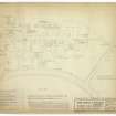
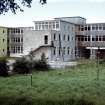
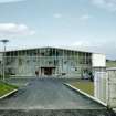
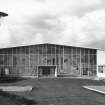
In 1950 Lanarkshire County Council commissioned Basil Spence & Partners to build a new high school on an 18-acre, green-field site, nine miles south of Glasgow. Opened in September 1956, Duncanrig was the first school built in East Kilbride, Scotland's first designated New Town.
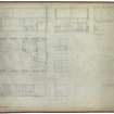
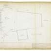
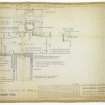
The school was designed for 850 pupils. It consists of a double height entrance foyer flanked by a single storey dining/kitchen and administration blocks. To the rear of the foyer is the assembly hall and gymnasium block. Seven two- and three-storey classroom blocks housing 22 classrooms are accessed from the ground floor corridor. They include technical classrooms, science labs, art rooms, a domestic science suite and library. There is also a boiler house and janitor's house.
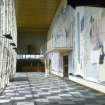
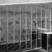
The external finishes are coursed rubble, cedar boarding and blue and yellow painted roughcast render. The school buildings cover just seven acres of the site with the remaining 11 acres used for playgrounds, playing fields and landscaping. William Crosbie's mural representing the history of the Clyde covers the internal wall of the foyer.
Duncanrig High School was demolished in 2007.
Archive Details and Summary
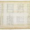
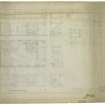
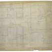
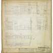
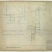
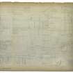
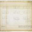
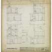
The Spence Glover & Ferguson Collection contains over 450 drawings, 18 photographs and 29 colour slides relating to Duncanrig School dating from 1950 to 1956. The colour slides that were taken by the practice soon after the school was opened illustrate the careful consideration given to colours, textures and light both inside and outside of the school. They show that each of the two-storey classroom blocks had a sun terrace, although these have since been filled in.
The Collection includes preliminary drawings by Basil Spence dating from 1950. These show a number of unexecuted schemes including one with an eight-storey classroom block and one that had a large exhibition space.
The Collection also illustrates that the practice designed the school so that boys and girls could be kept apart for a number of activities. As well as segregated classes there were two gymnasia, separate playgrounds, cloakrooms and even entrances. The drawings show that the practice's treatment of the boys' and girls' entrances was different. The girl's entrance was timber clad with flower boxes, whereas the boy's entrance was given a more robust finish of stone and rubble.
The Sir Basil Spence Archive contains one presentation photograph of Duncanrig School.
This text was written as one of the outputs of the Sir Basil Spence Archive Project, supported by the Heritage Lottery Fund, 2005-08.


ARCHITECT: Basil Spence and Partners 1953-6
Comprises an extended spine of classroom blocks, with symmetrical entrance/hall group around courtyard located to west. Mural in main entrance hall by William Crosbie.
M Glendinning 1997
Archaeological Evaluation (December 2005)
NS 617 540 An archaeological evaluation was carried out during December 2005 at the Duncanrig Secondary School site to satisfy a condition of planning consent for the construction of a new school. The site appears to have been undeveloped until the mid-1950s when the present school was first built and limited landscaping was carried out for playing fields. No archaeological deposits or features were recorded during the evaluation, other than modern land drains cut through truncated natural deposits and some evidence of ponding.
Archive and report to be deposited in NMRS. Report lodged with WoSAS SMR.
Sponsor: South Lanarkshire Council.
A Dutton 2006

