
Pricing Change
New pricing for orders of material from this site will come into place shortly. Charges for supply of digital images, digitisation on demand, prints and licensing will be altered.
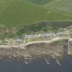
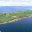
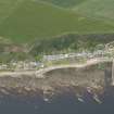
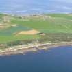
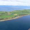
Rockfield, General


General View (Period Unassigned)
Site Name Rockfield, General
Classification General View (Period Unassigned)
Canmore ID 15646
Site Number NH98SW 22
NGR NH 9234 8287
NGR Description Centred NS 9234 8287
Datum OSGB36 - NGR
Permalink http://canmore.org.uk/site/15646


- Council Highland
- Parish Tarbat
- Former Region Highland
- Former District Ross And Cromarty
- Former County Ross And Cromarty
NH98SW 22 centred 9234 8287
See also NH98SW 29.
Village; houses - stable condition.
CFA/MORA Coastal Assessment Survey 1998.

