
Toum


Cairn (Prehistoric)
Site Name Toum
Classification Cairn (Prehistoric)
Canmore ID 15447
Site Number NH92SE 7
NGR NH 9601 2173
Datum OSGB36 - NGR
Permalink http://canmore.org.uk/site/15447


- Council Highland
- Parish Duthil And Rothiemurchus
- Former Region Highland
- Former District Badenoch And Strathspey
- Former County Inverness-shire
NH92SE 7 9601 2173.
(NH 9601 2173) Cairn (NR)
OS 6"map, Inverness-shire, 2nd ed., (1903)
A cairn consisting wholly of loose stones, situated near the farm of Ochnoir. It is not known to have been opened.
Name Book 1871.
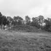
A cairn of bare stones situated on a false crest at about 900ft OD., measuring 24.0m N-S by 20.0m E-W and 3.0m high. It is virtually untouched and in good condition, although some stones have been dsplaced and lie at the base of the cairn. No kerb or other structures are visible.
Resurveyed at 1/2500.
Visited by OS (N K B) 16 September 1966.
Field Visit (25 September 1943)
Cairn, Toum.
This monument stands on a level terrace just NE of Toum farm buildings in the direction of Ochnair farm. It consists of a huge pile of bare fragments of rock with turf encroaching slightly at its base. The stones on the flanks have been disturbed to some extent and a hole dug in its summit and subsequently filled up with old tins and similar rubbish. No cists, chamber nor peristalith has been thereby exposed to view but the diamteres and elevation have been distorted. Today, the cairn is fully 11’ high and measures overall 96’ N-S by 88’ E’W.
In the thin woodland round the cairn are probably remains of small cairns overgrown with thick grass.
The great cairn is an impressive monument worthy of preservation.
Visited by RCAHMS (VGC, AG) 25 September 1943.
Map ref: xlvi (’Cairn’)
External Reference (2011)
'This magnificent site is, without question, the finest of the remaining Bronze Age cairns in this middle portion of Strathspey. Standing on a sloping terrace which commands clear views to the east and south over the valley, the cairn structure still rises some 4m. The flattened summit of the cairn suggests that it may have been looted at some stage in the past, but the sides of the boulder heap show no signs of disturbance. There are traces of a possible kerb on the south side.' (Oram 1996, p. 32)
Visit in autumn 2011 by Sue Murray, ARCH Community Timeline course, shows rubbish has been tipped into the cairn.
Information from the ARCH Community Timeline course, 2011

