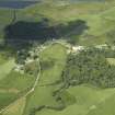
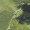
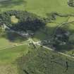
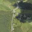
Accessibility

Font Size

100% 150% 200%

Background Colour

Default Contrast
Close Reset

Millhouse

Township (Period Unassigned)

Site Name Millhouse

Classification Township (Period Unassigned)

Canmore ID 154445

Site Number NR97SE 42

NGR NR 9567 7035

Datum OSGB36 - NGR

Permalink http://canmore.org.uk/site/154445

Ordnance Survey licence number AC0000807262. All rights reserved.
Canmore Disclaimer. © Bluesky International Limited 2025. Public Sector Viewing Terms

Toggle Aerial | View on large map

Digital Images

Oblique aerial view centred on the township and village, taken from the SE.
Oblique aerial view centred on the township and village, taken from the SE.Oblique aerial view centred on the township and village, taken from the SE.Oblique aerial view centred on the township and village, taken from the WNW.Oblique aerial view centred on the township and village, taken from the SW.

Collections

Administrative Areas

  • Council Argyll And Bute
  • Parish Kilfinan
  • Former Region Strathclyde
  • Former District Argyll And Bute
  • Former County Argyll

Activities

Note

A township, comprising nine roofed buildings, one unroofed building and four enclosures is depicted on the 1st edition of the OS 6-inch map (Argyllshire and Buteshire 1873, sheet cxciii). Five roofed buildings are shown on the current edition of the OS 1:10000 map (1981).

Information from RCAHMS (AKK) 7 June 1999.

References

MyCanmore Image Contributions


Contribute an Image

MyCanmore Text Contributions