
Kilmory


Township (Post Medieval)
Site Name Kilmory
Classification Township (Post Medieval)
Canmore ID 154279
Site Number NR77NW 34
NGR NR 70259 75141
NGR Description Centred NR 70259 75101
Datum OSGB36 - NGR
Permalink http://canmore.org.uk/site/154279


- Council Argyll And Bute
- Parish South Knapdale
- Former Region Strathclyde
- Former District Argyll And Bute
- Former County Argyll
Note
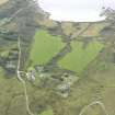
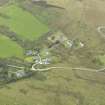
A township, comprising twenty-three roofed buildings, one partially roofed building, six unroofed buildings, one of which is a chapel (see NR77NW 3), is depicted on the 1st edition of the OS 6-inch map (Argyllshire 1873, sheet cxc). Seven roofed, two partially roofed and four unroofed buildings are shown on the current edition of the OS 1:10000 map (1979).
Information from RCAHMS (AKK) 17 May 1999.

