
Pricing Change
New pricing for orders of material from this site will come into place shortly. Charges for supply of digital images, digitisation on demand, prints and licensing will be altered.
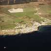
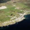
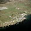
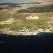
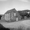
Islay, Octomore, Distillery And Farmstead


Distillery (Period Unassigned)(Possible), Farmstead (Period Unassigned), Township (Period Unassigned)
Site Name Islay, Octomore, Distillery And Farmstead
Classification Distillery (Period Unassigned)(Possible), Farmstead (Period Unassigned), Township (Period Unassigned)
Canmore ID 153889
Site Number NR25NW 75
NGR NR 2485 5895
NGR Description Centred on NR 248 589
Datum OSGB36 - NGR
Permalink http://canmore.org.uk/site/153889


- Council Argyll And Bute
- Parish Kilchoman
- Former Region Strathclyde
- Former District Argyll And Bute
- Former County Argyll
NR25NW 75 centred on 2485 5895
A township comprising one unroofed building, one partially roofed building, eight roofed buildings, two of which are long buildings and one of these is L-shaped, and three enclosures is depicted on the OS 1st edition 6-inch map (Argyllshire 1882, sheet ccvii). Five roofed buildings and three enclosures are shown on the current edition of the OS 1:10000 map (1981).
Information from RCAHMS (SAH) 9 November 1998
It is likely that these buildings once functioned as Octomore Distillery
Information from RCAHMS (SDC) 27th September 2000

