
Pricing Change
New pricing for orders of material from this site will come into place shortly. Charges for supply of digital images, digitisation on demand, prints and licensing will be altered.
Cadderlie


Bothy (20th Century) (1994), Head Dyke (Post Medieval), Sheepfold(S) (Modern), Shepherds Cottage (Early 20th Century), Township (Post Medieval)
Site Name Cadderlie
Classification Bothy (20th Century) (1994), Head Dyke (Post Medieval), Sheepfold(S) (Modern), Shepherds Cottage (Early 20th Century), Township (Post Medieval)
Canmore ID 153668
Site Number NN03NW 1
NGR NN 0463 3698
Datum OSGB36 - NGR
Permalink http://canmore.org.uk/site/153668


- Council Argyll And Bute
- Parish Ardchattan And Muckairn (Argyll And Bute)
- Former Region Strathclyde
- Former District Argyll And Bute
- Former County Argyll
NN03NW 1.00 0460 3700
NN03NW 1.01 046 369 Cottage: Cruck-framed
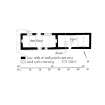
A township, comprising eight roofed buildings, three partially roofed buildings, five unroofed buildings, three enclosures, one of which is annotated as 'Sheepfold', and two lengths of head-dyke is depicted on the 1st edition of the OS 6-inch map (Argyllshire 1875, sheet lxxxviii). One roofed, one partially roofed building, four unroofed buildings and two sheepfolds are shown on the current edition of the OS 1:10000 map (1974).
Information from RCAHMS (AKK) 4 August 1998.
Field Visit (July 1970)
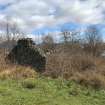
Cruck-framed Building, Cadderlie.
This is the best preserved of a small group of buildings situated on level ground about 220 m from the W shore of Loch Etive and 5 km NE of Bonawe Quarries. It comprises a dwelling-house and byre, each originally of five bays divided by cruck-trusses, and is probably of late 18th- or early 19th-century date. The byre, which is now roofless, remains substantially unaltered, although the wall-head has been raised by 0.53 m at a recent period. The dwelling-house was remodelled in about the middle of the 19th century, and further blocking of windows took place when it subsequently passed out of domestic use.
The building measures 22'5 m by 5'3 m over walls (Fig. 226). The long axis runs from ESE to WNW but will be described as if from E to W. A massive boulder-plinth supports walls of lime-mortared granite rubble which have been harled and whitewashed. In both parts of the building the cruck-couples have been sawn off below wall-head level; the surviving stumps are scarf-jointed with wooden pegs. The byre, which occupies the W portion of the structure, is entered by a door in the N wall; there are no other openings. A stone-built drain passes below the wall to the E of the door and can be traced for about 6 m, leading into lower ground to the N of the dwelling.
In the original arrangement, the dwelling-house had opposed doorways in the N and S walls about 7.6 m from the E wall. There is no evidence of window openings; if these existed, they must have been in the central bay where there are later openings. The substantial wall separating byre from dwelling, although not bonded into the side-walls, is probably an original feature; the consistent spacing of the cruck-couples suggests this, and the wall certainly antedates the comprehensive remodelling that turned this simple dwelling into an improved cottage of normal 19th-century type. In its altered form the house had a central doorway in the S wall, flanked by windows; in the N wall there is an additional opening which preserves its small sash window. Although no evidence of internal partitions survives, there were evidently two principal rooms, each having an inserted fireplace in the end-wall. The new plan required a different system of bays, and the cruck-couples were removed before alterations began.
RCAHMS 1975, visited July 1970
Note (6 July 2022)
NN03NW 1 NN 04595 37012
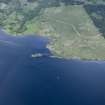
This 20th century shepherd’s cottage, now a bothy, is situated on the NW shore of Loch Etive 5km NNE of the public road at Bonawe. The cottage stands within a township represented by the ruins of ten buildings, and there are six other buildings in the surrounding arable ground. A well-preserved cruck-framed building stands about 40m SE of the bothy (NN03NW 1.01; RCAHMS 1975, 269, No. 339). The township is at the centre of a large area of formerly cultivated ground that extends along the shore for about 900m in each direction, and some 1.1km to the NW where it is contained within a series of head dykes (e.g. at NN 03807 37663).
Roy’ Military Map (1747-55) shows an indicative patch of cultivation at Cadderlie indicating that the area was settled at that date. The OS map of 1875 provides a detailed depiction that shows the cruck-framed building and 15 other buildings, some roofed, some clearly unroofed (Argyllshire, Sheet LXXXVIII, 1875). By 1897 only two buildings were still occupied (Argyll and Bute LXXXVIII.NE, 1900). A roofed building annotated ‘Bothy’ and series of unroofed buildings and enclosures are shown on the current edition of the OS 1:10,000 digital map.
In the 1870s the officers of the OS noted that Robert the Bruce had slept at Cadderlie after the Battle of Brander in the 14th century (OS Name Book, Argyllshire, No. 52 p.25), while documents of the 15th, 16th and 17th centuries mention up to four settlements in the area (OPS 1846, pp.148-158). In a detailed report on the history of Cadderlie, Mhairi Ross noted the long connection of the township with the family of McIntyre from the 17th to the 19th centuries (Ross 2011). In 1871, ‘Cadderly farm house’ was occupied by Samuel McIntyre (65), a retired farmer, his sister Catherine (56), and her husband Donald McColl (56), a farm servant. The McIntyres of Cadderlie were the source for many of the placenames in the area in the 1870s (OS Name Book No. 52). Successive occupiers included shepherds Duncan Black in 1885, Alexander McGillivray in 1905 and Hugh Macallum in 1935 (Valuation Rolls). The bothy was last occupied by an Angus MacTavish in 1948.
Information from HES Archaeological Survey (D M Bratt and G F Geddes) 6 July 2022.
(Allan 2017, 206-9)

