Pricing Change
New pricing for orders of material from this site will come into place shortly. Charges for supply of digital images, digitisation on demand, prints and licensing will be altered.
Lerwick, Freefield, Hay's Dock, Hay And Company, Boatbuilding Yard
Boat Yard (19th Century)
Site Name Lerwick, Freefield, Hay's Dock, Hay And Company, Boatbuilding Yard
Classification Boat Yard (19th Century)
Alternative Name(s) Lerwick Harbour; Bressay Sound
Canmore ID 152428
Site Number HU44SE 72.01
NGR HU 4733 4179
NGR Description Centred HU 4733 4179
Datum OSGB36 - NGR
Permalink http://canmore.org.uk/site/152428
- Council Shetland Islands
- Parish Lerwick
- Former Region Shetland Islands Area
- Former District Shetland
- Former County Shetland
HU44SE 72.01 4733 4179
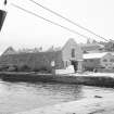
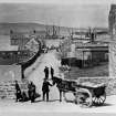
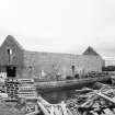
This boatbuilding yard which is adjacent to the S side of Hay's Dock (HU44SE 72.00) was established during the last quarter of the 19th century. However, repair work may have been carried out for as long as Hay and Company have been in existence. The yard closed in the 1950s.
The main shed is a 6 bay timber framed structure with timber clad walls, except for the S wall which is of rubble construction. The roof is of corrugated cement asbestos sheets. It has a concrete floor and a sliding double doors in the N end. These replaced earlier hinged doors. This building is depicted on the 2nd edition of the OS 25-inch map (Shetland, 1900, sheets LIII.9 and LIII.13) but not on the 1st edition (Shetland, 1978, sheets LIII.9 and LIII.13). There was a large hand-powered winch for the slipway by the inside S wall. This is now used as a timber store. The small shed (HU4732 4719) butting onto the W wall of the main shed is a 9 bay timber framed structure. It has timber clad walls, a corrugated asbestos sheet roof, a concrete floor and a large sliding door in the N end.
The slipway (HU4732 4182) was roughly cobbled/paved but is now of concrete. It had temporary sliders /rails of timber along with a 'slid and shoe' type wooden cradle for the boat. This slipway is depicted on the 2nd edition of the OS 25-inch map (Shetland, 1900, sheets LIII.9 and LIII.13) but not on the 1st edition (Shetland, 1978, sheets LIII.9 and LIII.13).
Visited by RCAHMS (GJD) 18 October 1994.
The ill-defined area of Lerwick Harbour (HU44SE 32: centred HU 47722 41345) essentially forms an extensive roadstead which comprises the waters of Bressay Sound between the narrow Northern entrance (around HU 475 445) and the broader Southern entrance (around HU 483 400). The main facilities are to be found around HU 477 414, on the W side of the Sound; recent development extends Northwards from this point.
Information from RCAHMS (RJCM), 5 October 2007.


