
Following the launch of trove.scot in February 2025 we are now planning the retiral of some of our webservices. Canmore will be switched off on 24th June 2025. Information about the closure can be found on the HES website: Retiral of HES web services | Historic Environment Scotland
Glensanda


Farmstead (Period Unassigned), Field System (Period Unassigned), Head Dyke (Post Medieval), Township (Period Unassigned)
Site Name Glensanda
Classification Farmstead (Period Unassigned), Field System (Period Unassigned), Head Dyke (Post Medieval), Township (Period Unassigned)
Canmore ID 152297
Site Number NM84NW 4
NGR NM 821 468
NGR Description Centred on NM 821 468
Datum OSGB36 - NGR
Permalink http://canmore.org.uk/site/152297


- Council Highland
- Parish Ardgour
- Former Region Highland
- Former District Lochaber
- Former County Argyll
NM84NW 4 centred on 821 468
See also:
NM84NW 1 NM 8238 4686 Tower-house
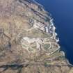
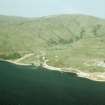
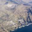
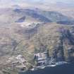
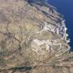
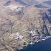
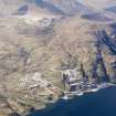
A township, farmstead and a field-system (NM 823 468) are depicted on the 1st edition of the OS 6-inch map (Argyllshire 1875, sheet lvi). The township comprises five unroofed buildings, one of which is a long building of two compartments, two sheepfolds and a head-dyke. The farmstead comprises five roofed buildings, one of which is T-shaped and another has two wings, and three enclosures.
The township, farmstead and the fragmentary remains of the field-system are are shown on the current edition of the OS 1:10000 map (1974). The township comprises one unroofed building, one enclosure and the head-dyke. The farmstead comprises three roofed buildings and one enclosure.
Information from RCAHMS (SAH) 19 May 1998

