
Dunstaffnage Castle


Building(S) (Period Unassigned), Enclosure (Period Unassigned)
Site Name Dunstaffnage Castle
Classification Building(S) (Period Unassigned), Enclosure (Period Unassigned)
Canmore ID 152287
Site Number NM83SE 55
NGR NM 8820 3443
Datum OSGB36 - NGR
Permalink http://canmore.org.uk/site/152287


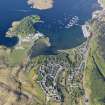
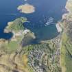
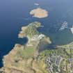
- Council Argyll And Bute
- Parish Ardchattan And Muckairn (Argyll And Bute)
- Former Region Strathclyde
- Former District Argyll And Bute
- Former County Argyll
Note
One unroofed building, one partially roofed long building of five compartments and one enclosure are depicted on the 1st edition of the OS 6-inch map (Argyllshire 1876, sheet lxxxvi), but they are not shown on the current edition of the OS 1:10000 map (1976).
Information from RCAHMS (SAH) 3 September 1998

