
Unknown: Siccar Rock, Dunbar, Firth Of Forth


Anchor(S) (Stone)(Period Unassigned)
Site Name Unknown: Siccar Rock, Dunbar, Firth Of Forth
Classification Anchor(S) (Stone)(Period Unassigned)
Alternative Name(s) Bush Of Blackstanes; Sicar Rock; Outer Forth Estuary
Canmore ID 151710
Site Number NT77NW 8005
NGR NT 7026 7998
NGR Description Centred NT 7026 7998
Datum Datum not recorded
Permalink http://canmore.org.uk/site/151710


- Council East Lothian
- Parish Maritime - East Lothian
- Former Region Lothian
- Former District Maritime
- Former County Not Applicable
NT77NW 8005 centred 7026 7998
N 56 00.714 W2 28.617
NLO: Dunbar [name: NT 678 790].
Possibly on map sheet NT78SW.
Three stone anchors have been found in amateur diving at 56 00.714N 2 28.617W. [Present location not recorded].
Information from Ms L C A Goudie, 29 Damhead, Lothianburn EH10 7EA per Receiver of Wreck.
NMRS, MS/829/20.
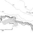
The location indicated converts to NGR NT 7026 7998 and falls 2.4nm ENE of Dunbar harbour, on the outer limit of the Bush of Blackstanes ridge. The charted depth is 29m.
Information from RCAHMS (RJCM), 25 November 1999.
HO chart 175, 1996 ed.
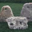
(Name cited as Sicar Rock). To date, three anchors and one oddly-shaped piece of stone have been raised; a further three anchors (one of them incomplete) remain on the seabed. All the anchors are of perforated and triangular form with a circular hole at the apex and a rectangular hole at the base.All those raised have been retained by the finder.
Those raised are as follows:
A. An anchor of sandstone or other sedimentary rock, 45cm high, with a round hole of 5cm diameter and a rectangular hole measuring 9 by 5cm. Raised 25 July 1999.
B. An anchor of sandstone or other sedimentary rock, 53cm high, with a round hole of 5cm diameter and a rectangular hole measuring 7.5 by 5cm. Raised 5 September 1999.
C. A broken anchor of ?limestone and ?44cm high, with a round hole of 5cm diameter and a rectangular hole measuring 7 by 5cm. Raised 3 October 1999.
The strangely-shaped piece of stone has a portion possibly broken off.
One of the three anchors that remain on the seabed is broken, with only one hole remaining.
[Photos supplied also include a metal object, probably a ring-bolt].
Additional information from Ms L Goudie, 8 January 2000.
NMRS, MS/829/20; NMRS, E/88826-34/po.
The Sicar [Siccar] Rock assemblage of stone anchors is one of three groups known in the UK. So far no stone anchors from the UK have been found in a datable context and so it is difficult to determine their age. Generally the UK examples averaging approximately 17Kg, are significantly smaller than those from the Mediterranean, and may be too small to be an anchor for anything other than the smallest boat. It is possible that the majority of UK examples are related to a lost fishing method and it may be significant they are often found at sites where crab and lobster potting takes place today.
Crude stone anchors were in use well into the 20th century on small fishing boats in the south of England. The majority recovered by divers and fishermen are generally worked either into a round/amorphous shape with one hole for a rope, or into a trapezoid with more than one hole. There is usually a rope hole at the top and one or more sub-rectangular holes, presumably to take wooden or bone cross pieces to act as a flukes, lower down in the wider part of the anchor. There may be regional variations; stone anchors of this shape from the south of England generally have two holes for the flukes whereas those in Scotland have one fluke hole. A fragment of a single-hole example is known from Hartlepool and this has an incised cross which could indicate a date after the advent of Christianity.
Information from Mr M Dean (Director, Archaeological Diving Unit), November 2000.
Four of these anchors have been passed to Dunbar Town House Musem for future display.
Additional information from Ms L Goudie, 26 January 2001 and 1 October 2003.
The four anchors that were left on the seabed have been removed.
Additional information from Ms L Goudie, 1 October 2003.
(Site-name cited as Sicar Rock). This site has been adopted under the Nautical Archaeology Society 'Adopt a Wreck' scheme.
Source: NAS Newsletter, November 2004.
(Location cited as N56 0.8 W2 28.395 [NT 7049 8014]). In 1998, two recreational divers noticed a pierced stone object of unrecognised nature whilst diving under good conditions at Sicar [Siccar] Rock. It was raised about a year later, together with three others noticed in succession, and reported to the Receiver of Wreck. Siccar Rock is of volcanic origin and stands isolated about 1km offshore, where it rises about 13m from the seabed to a depth of about 7m at Low Water Springs. The local tidal range is about 6m at springs.
The stones were found in between 20 and 25m depth of water on a rocky seabed of stones and boulders with coarse sand in places. They lay scattered along an E-W line (between 30 and 50m long) to the S of the rock and at no regular spacing, some being within 2m of each other, and others much further apart.
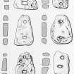
All the stones are roughly triangular in shape, with two piercings and a flat cross-section. In stones A, B and C the hole at the apex is circular while that at the base is rectangular, and each is flush with the surface. In stones D, E and F the holes are slightly funnelled at base and apex; the holes at the apex of each of the latter two stones are more oval than round. Each weighs between 35 and 27kg.
The following dimensions have been recorded:
A: height 43cm, max. width 42cm, thickness 9cm, apex hole 3.5cm diameter, base holes 8x4cm.
B: height 55cm, max. width 35cm, thickness 7cm, apex hole 6cm diameter, base holes 8x6cm.
C: height 50cm, max. width 35cm, thickness 9cm, apex hole 3cm diameter, base holes 5.5x3cm.
D: height 45cm, max. width 29cm, thickness 10cm, apex hole 2.5cm diameter, base holes 3.4cm diameter.
E: height 54cm, max. width 43cm, thickness 8cm, apex hole 6.5x4cm, base holes 3x4cm.
F: height 46cm, max. width 27cm, thickness 16cm, apex hole 6.5x4cm, base holes 5x3cm.
The stones display considerable wear on their lower surfaces, more notably on one side. Stones A, B and C display grooving at the apex and apex hole, suggesting rope-abrasion. It is not easy to discern toolmarks on the stones as they (notably B and F) are encrusted with marine life, but stone A displays what may be toolmarks on one surface. Petrologically, the stones have been identified as carboniferous sandstone, with consequent magnetic susceptibility; evidence of organic material is apparent on the broken stone C. A ring-shaped stone found beside stone F has not been examination; its date, composition and provenance remain unclear. A spherical stone with a single stone is known to lie to the N of Sicar Rock.
The date, provenance and composition of these stones remain unclear, but they may be of local origin. They are apparently without archaeological and ethnographic parallel in Scotland, and were thus unlikely to have been used in fishing. The 'cappies' that are recorded as in use for fishing off Shetland are smaller, less carefully shaped, and have a single hole, placed centrally. A pierced stone of unknown function and origin is held at the Seil Island Folk Museum, Argyll; this is pear-shaped and 40cm long, with a single round hole of about 7cm diameter. The Sicar Rock stones may have been left by a vessel breaking up in a tidal stream.
(Illustrated with location plans, drawings and sections of all stones, and photograph of stone B).
L Goudie 2005.
(Name formerly cited as Bush of Blackstanes: re-entered as Sicar Rock). The precise location of this discovery remains unclear; no position-fixing method is specified in any report and the degree of accuracy cannot be determined. That cited in the initial report is retained.
The rock of Sicar is noted by HO at the cited location, 1.3nm ENE of Dunbar. It rises to a charted depth of 7.9m from a general depth of 28m; no seabed type is indicated.
Information from RCAHMS (RJCM), 10 October 2005.
HO chart no. 734 (published 1993, revised 1995).
Petrological analysis was conducted by the British Geological Survey of six stone anchors ('pierced stones') found near Sicar [Siccar] Rock, and now held by East Lothian Museums Service. Both macrosopic and microscopic techniques were used.
The stones are all quartz-rich sandstones with a relatively high (although variable) iron oxide content. In consequence, they vary considerably in colour and texture, but are generally well compacted, with visible bedding and a relatively high matrix content dominated by iron oxide. Some have a considerable carbonate content.
Stones A, B, C and E are generally fine-grained, quartz-rich sandstone with uniform grain size distribution, and stony compaction with a well-developed silica cement. These are classified as subarkose sandstone.
Stones D and F are a coarse-grained impure sandstone with variable grain size and a high content of fine-grained matrix haematite and carbonate. These are classified as arkosic wackestone.
All six stones display the characteristics of stones found within the Devonian and Carboniferous sedimentary rocks of the Dunbar area. No more detailed provenance can be suggested.
NMRS, MS/3031.
Diver Inspection (1 January 1999 - 31 December 2003)
Diver and sonar survey (in 2000 and 2001) of a total of eight, small stone anchors (of a fairly rare type) which were used locally by fishing vessels well into the 20th century. Three were recovered prior to ADU examination of the site in 2000; with the final four being recovered by 2003. All six were lated analysed by the British Geological Survey. Although the sonar did not revealed any other items at the site, it was adopted under the NAS Adopt-a-Wreck scheme.
Information from OASIS ID: englishh1-93859 (M Lawrence) 2003
Note (25 November 1999)
The location indicated converts to NGR NT 7026 7998 and falls 2.4nm ENE of Dunbar harbour, on the outer limit of the Bush of Blackstanes ridge. The charted depth is 29m.
Information from RCAHMS (RJCM), 25 November 1999.
HO chart 175, 1996 ed.
Diver Inspection (29 August 2000 - 30 August 2000)
Note (10 October 2005)
(Name formerly cited as Bush of Blackstanes: re-entered as Sicar Rock). The precise location of this discovery remains unclear; no position-fixing method is specified in any report and the degree of accuracy cannot be determined. That cited in the initial report is retained.
The rock of Sicar is noted by HO at the cited location, 1.3nm ENE of Dunbar. It rises to a charted depth of 7.9m from a general depth of 28m; no seabed type is indicated.
Information from RCAHMS (RJCM), 10 October 2005.
HO chart no. 734 (published 1993, revised 1995).
Reference (2005)
(Location cited as N56 0.8 W2 28.395 [NT 7049 8014]). In 1998, two recreational divers noticed a pierced stone object of unrecognised nature whilst diving under good conditions at Sicar [Siccar] Rock. It was raised about a year later, together with three others noticed in succession, and reported to the Receiver of Wreck. Siccar Rock is of volcanic origin and stands isolated about 1km offshore, where it rises about 13m from the seabed to a depth of about 7m at Low Water Springs. The local tidal range is about 6m at springs.
The stones were found in between 20 and 25m depth of water on a rocky seabed of stones and boulders with coarse sand in places. They lay scattered along an E-W line (between 30 and 50m long) to the S of the rock and at no regular spacing, some being within 2m of each other, and others much further apart.
All the stones are roughly triangular in shape, with two piercings and a flat cross-section. In stones A, B and C the hole at the apex is circular while that at the base is rectangular, and each is flush with the surface. In stones D, E and F the holes are slightly funnelled at base and apex; the holes at the apex of each of the latter two stones are more oval than round. Each weighs between 35 and 27kg.
The following dimensions have been recorded:
A: height 43cm, max. width 42cm, thickness 9cm, apex hole 3.5cm diameter, base holes 8x4cm.
B: height 55cm, max. width 35cm, thickness 7cm, apex hole 6cm diameter, base holes 8x6cm.
C: height 50cm, max. width 35cm, thickness 9cm, apex hole 3cm diameter, base holes 5.5x3cm.
D: height 45cm, max. width 29cm, thickness 10cm, apex hole 2.5cm diameter, base holes 3.4cm diameter.
E: height 54cm, max. width 43cm, thickness 8cm, apex hole 6.5x4cm, base holes 3x4cm.
F: height 46cm, max. width 27cm, thickness 16cm, apex hole 6.5x4cm, base holes 5x3cm.
The stones display considerable wear on their lower surfaces, more notably on one side. Stones A, B and C display grooving at the apex and apex hole, suggesting rope-abrasion. It is not easy to discern toolmarks on the stones as they (notably B and F) are encrusted with marine life, but stone A displays what may be toolmarks on one surface. Petrologically, the stones have been identified as carboniferous sandstone, with consequent magnetic susceptibility; evidence of organic material is apparent on the broken stone C. A ring-shaped stone found beside stone F has not been examination; its date, composition and provenance remain unclear. A spherical stone with a single stone is known to lie to the N of Sicar Rock.
The date, provenance and composition of these stones remain unclear, but they may be of local origin. They are apparently without archaeological and ethnographic parallel in Scotland, and were thus unlikely to have been used in fishing. The 'cappies' that are recorded as in use for fishing off Shetland are smaller, less carefully shaped, and have a single hole, placed centrally. A pierced stone of unknown function and origin is held at the Seil Island Folk Museum, Argyll; this is pear-shaped and 40cm long, with a single round hole of about 7cm diameter. The Sicar Rock stones may have been left by a vessel breaking up in a tidal stream.
(Illustrated with location plans, drawings and sections of all stones, and photograph of stone B).
L Goudie 2005.
Reference (2 February 2007)
Petrological analysis was conducted by the British Geological Survey of six stone anchors ('pierced stones') found near Sicar [Siccar] Rock, and now held by East Lothian Museums Service. Both macrosopic and microscopic techniques were used.
The stones are all quartz-rich sandstones with a relatively high (although variable) iron oxide content. In consequence, they vary considerably in colour and texture, but are generally well compacted, with visible bedding and a relatively high matrix content dominated by iron oxide. Some have a considerable carbonate content.
Stones A, B, C and E are generally fine-grained, quartz-rich sandstone with uniform grain size distribution, and stony compaction with a well-developed silica cement. These are classified as subarkose sandstone.
Stones D and F are a coarse-grained impure sandstone with variable grain size and a high content of fine-grained matrix haematite and carbonate. These are classified as arkosic wackestone.
All six stones display the characteristics of stones found within the Devonian and Carboniferous sedimentary rocks of the Dunbar area. No more detailed provenance can be suggested.
NMRS, MS/3031.
Archaeological Evaluation (25 October 2012 - 25 October 2012)
WA Coastal and Marine was commissioned by Historic Scotland to undertake an undesignated assessment of the reported findspot of a number of carved stone artefacts off the coast of Dunbar in East Lothian. The artefacts were thought to represent stone anchors of unknown date with a total number of around eight, approximately half of which had been removed from the site and placed in a local museum. Although the survey failed to locate any in situ material, the baseline research carried out for the project has helped to enhance our knowledge of this challenging site. In addition a new survey was undertaken of the previously recovered material and is presented here. During the course of survey and reporting a number of related artefacts from the site itself and other previously unknown sites were reported to the WA Coastal and Marine staff by local divers and these have been discussed in this report.
WA Coastal & Marine (J. McCarthy) OASIS ID: waherita1-136280

