
Camp Hill


Enclosure (Period Unassigned)
Site Name Camp Hill
Classification Enclosure (Period Unassigned)
Canmore ID 151178
Site Number NY29SE 106
NGR NY 25706 90546
Datum OSGB36 - NGR
Permalink http://canmore.org.uk/site/151178


- Council Dumfries And Galloway
- Parish Westerkirk
- Former Region Dumfries And Galloway
- Former District Annandale And Eskdale
- Former County Dumfries-shire
NY29SE 106 2568 9055
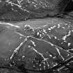
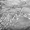
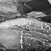
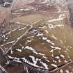
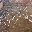
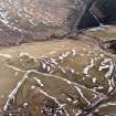
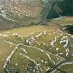
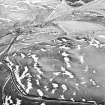
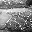
Oblique aerial photographs (RCAHMSAP 1996) have revealed the upstanding remains of a sub-circular enclosure 110m WNW of Bailiehill farmsteading (NY29SE 93). It has an internal diameter of about 20m with a possible opening at the NW side. A fort and settlement has been recorded approximately 60m to the W (NY29SE 8).
Information from RCAHMS (KJ) 15 November 1999.

