
Pricing Change
New pricing for orders of material from this site will come into place shortly. Charges for supply of digital images, digitisation on demand, prints and licensing will be altered.
Islay, Glenegedale, Farm


Farmstead (Period Unassigned)
Site Name Islay, Glenegedale, Farm
Classification Farmstead (Period Unassigned)
Alternative Name(s) Kildalton And Oa Estates
Canmore ID 151050
Site Number NR35SW 32
NGR NR 3316 5178
Datum OSGB36 - NGR
Permalink http://canmore.org.uk/site/151050
Ordnance Survey licence number AC0000807262. All rights reserved.
Canmore Disclaimer.
© Bluesky International Limited 2025. Public Sector Viewing Terms
- Correction
- Favourite

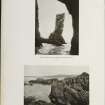
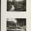
DP 112372
General oblique aerial view of Port Ellen Airfield, taken from the WSW.
RCAHMS Aerial Photography Digital
3/5/2011
© Crown Copyright: HES

DP 112374
General oblique aerial view of Port Ellen Airport and Machrie Hotel with the golf course adjacent, taken from the SSW.
RCAHMS Aerial Photography Digital
3/5/2011
© Crown Copyright: HES

DP 112376
General oblique aerial view of Port Ellen Airport and Machrie Hotel with the golf course adjacent, taken from the S.
RCAHMS Aerial Photography Digital
3/5/2011
© Crown Copyright: HES

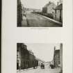
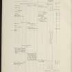
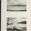
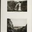
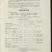
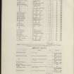
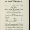
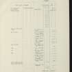
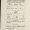
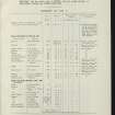
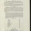
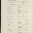
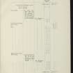
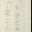
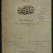
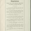
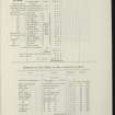
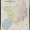
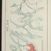
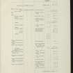
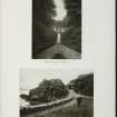
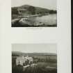
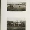
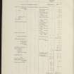
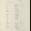
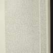
SC 2139380
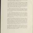
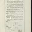
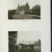
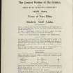
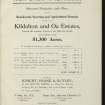
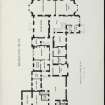
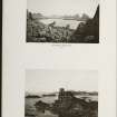
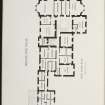
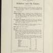
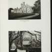
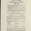
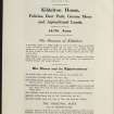
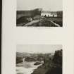
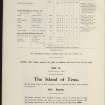
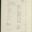
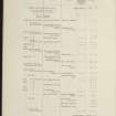
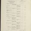
Estate Exchange. Kildalton and Oa Esatates. no. 1484 Sales Brochure. Includes details of 4 different lots: Corraray (lot 4), Lower Cragabus (lot 2), Castlehill, Duich (lot 4), Kilbride (lot 3), Machrie (lot 3) etc. Map and text. Title: 'The Kildalton and Oa Estates, Argyllshire. The Property of Iain Ramsay Esq. J.P.'
Collection of sale catalogues relating to Scottish estates
25/6/1914
© Courtesy of HES (Estates Exchange Collection)

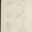
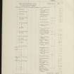
SC 2139389
Estate Exchange. Kildalton and Oa Esatates. no. 1484 Sales Brochure. Includes details of 4 different lots: Corraray (lot 4), Lower Cragabus (lot 2), Castlehill, Duich (lot 4), Kilbride (lot 3), Machrie (lot 3) etc. Map and text. Title: 'The Kildalton and Oa Estates, Argyllshire. The Property of Iain Ramsay Esq. J.P.'
Collection of sale catalogues relating to Scottish estates
25/6/1914
© Courtesy of HES (Estates Exchange Collection)

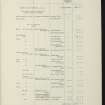
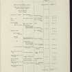
SC 2139399
Estate Exchange. Kildalton and Oa Esatates. no. 1484 Sales Brochure. Includes details of 4 different lots: Corraray (lot 4), Lower Cragabus (lot 2), Castlehill, Duich (lot 4), Kilbride (lot 3), Machrie (lot 3) etc. Map and text. Title: 'The Kildalton and Oa Estates, Argyllshire. The Property of Iain Ramsay Esq. J.P.'
Collection of sale catalogues relating to Scottish estates
25/6/1914
© Courtesy of HES (Estates Exchange Collection)

SC 2139402
Estate Exchange. Kildalton and Oa Esatates. no. 1484 Sales Brochure. Includes details of 4 different lots: Corraray (lot 4), Lower Cragabus (lot 2), Castlehill, Duich (lot 4), Kilbride (lot 3), Machrie (lot 3) etc. Map and text. Title: 'The Kildalton and Oa Estates, Argyllshire. The Property of Iain Ramsay Esq. J.P.'
Collection of sale catalogues relating to Scottish estates
25/6/1914
© Courtesy of HES (Estates Exchange Collection)

SC 2139406
Estate Exchange. Kildalton and Oa Esatates. no. 1484 Sales Brochure. Includes details of 4 different lots: Corraray (lot 4), Lower Cragabus (lot 2), Castlehill, Duich (lot 4), Kilbride (lot 3), Machrie (lot 3) etc. Map and text. Title: 'The Kildalton and Oa Estates, Argyllshire. The Property of Iain Ramsay Esq. J.P.'
Collection of sale catalogues relating to Scottish estates
25/6/1914
© Courtesy of HES (Estates Exchange Collection)

SC 2139407
Estate Exchange. Kildalton and Oa Esatates. no. 1484 Sales Brochure. Includes details of 4 different lots: Corraray (lot 4), Lower Cragabus (lot 2), Castlehill, Duich (lot 4), Kilbride (lot 3), Machrie (lot 3) etc. Map and text. Title: 'The Kildalton and Oa Estates, Argyllshire. The Property of Iain Ramsay Esq. J.P.'
Collection of sale catalogues relating to Scottish estates
25/6/1914
© Courtesy of HES (Estates Exchange Collection)

SC 2139408
Estate Exchange. Kildalton and Oa Esatates. no. 1484 Sales Brochure. Includes details of 4 different lots: Corraray (lot 4), Lower Cragabus (lot 2), Castlehill, Duich (lot 4), Kilbride (lot 3), Machrie (lot 3) etc. Map and text. Title: 'The Kildalton and Oa Estates, Argyllshire. The Property of Iain Ramsay Esq. J.P.'
Collection of sale catalogues relating to Scottish estates
25/6/1914
© Courtesy of HES (Estates Exchange Collection)

SC 2139419
Estate Exchange. Kildalton and Oa Esatates. no. 1484 Sales Brochure. Includes details of 4 different lots: Corraray (lot 4), Lower Cragabus (lot 2), Castlehill, Duich (lot 4), Kilbride (lot 3), Machrie (lot 3) etc. Map and text. Title: 'The Kildalton and Oa Estates, Argyllshire. The Property of Iain Ramsay Esq. J.P.'
Collection of sale catalogues relating to Scottish estates
25/6/1914
© Courtesy of HES (Estates Exchange Collection)

SC 2139428
Estate Exchange. Kildalton and Oa Esatates. no. 1484 Sales Brochure. Includes details of 4 different lots: Corraray (lot 4), Lower Cragabus (lot 2), Castlehill, Duich (lot 4), Kilbride (lot 3), Machrie (lot 3) etc. Map and text. Title: 'The Kildalton and Oa Estates, Argyllshire. The Property of Iain Ramsay Esq. J.P.'
Collection of sale catalogues relating to Scottish estates
25/6/1914
© Courtesy of HES (Estates Exchange Collection)

SC 2139436
Estate Exchange. Kildalton and Oa Esatates. no. 1484 Sales Brochure. Includes details of 4 different lots: Corraray (lot 4), Lower Cragabus (lot 2), Castlehill, Duich (lot 4), Kilbride (lot 3), Machrie (lot 3) etc. Map and text. Title: 'The Kildalton and Oa Estates, Argyllshire. The Property of Iain Ramsay Esq. J.P.'
Collection of sale catalogues relating to Scottish estates
25/6/1914
© Courtesy of HES (Estates Exchange Collection)

SC 2139439
Estate Exchange. Kildalton and Oa Esatates. no. 1484 Sales Brochure. Includes details of 4 different lots: Corraray (lot 4), Lower Cragabus (lot 2), Castlehill, Duich (lot 4), Kilbride (lot 3), Machrie (lot 3) etc. Map and text. Title: 'The Kildalton and Oa Estates, Argyllshire. The Property of Iain Ramsay Esq. J.P.'
Collection of sale catalogues relating to Scottish estates
25/6/1914
© Courtesy of HES (Estates Exchange Collection)

SC 2139446
Estate Exchange. Kildalton and Oa Esatates. no. 1484 Sales Brochure. Includes details of 4 different lots: Corraray (lot 4), Lower Cragabus (lot 2), Castlehill, Duich (lot 4), Kilbride (lot 3), Machrie (lot 3) etc. Map and text. Title: 'The Kildalton and Oa Estates, Argyllshire. The Property of Iain Ramsay Esq. J.P.'
Collection of sale catalogues relating to Scottish estates
25/6/1914
© Courtesy of HES (Estates Exchange Collection)

SC 2139375
Estate Exchange. Kildalton and Oa Esatates. no. 1484 Sales Brochure. Includes details of 4 different lots: Corraray (lot 4), Lower Cragabus (lot 2), Castlehill, Duich (lot 4), Kilbride (lot 3), Machrie (lot 3) etc. Map and text. Title: 'The Kildalton and Oa Estates, Argyllshire. The Property of Iain Ramsay Esq. J.P.'
Collection of sale catalogues relating to Scottish estates
25/6/1914
© Courtesy of HES (Estates Exchange Collection)

SC 2139377
Estate Exchange. Kildalton and Oa Esatates. no. 1484 Sales Brochure. Includes details of 4 different lots: Corraray (lot 4), Lower Cragabus (lot 2), Castlehill, Duich (lot 4), Kilbride (lot 3), Machrie (lot 3) etc. Map and text. Title: 'The Kildalton and Oa Estates, Argyllshire. The Property of Iain Ramsay Esq. J.P.'
Collection of sale catalogues relating to Scottish estates
25/6/1914
© Courtesy of HES (Estates Exchange Collection)

SC 2139383
Estate Exchange. Kildalton and Oa Esatates. no. 1484 Sales Brochure. Includes details of 4 different lots: Corraray (lot 4), Lower Cragabus (lot 2), Castlehill, Duich (lot 4), Kilbride (lot 3), Machrie (lot 3) etc. Map and text. Title: 'The Kildalton and Oa Estates, Argyllshire. The Property of Iain Ramsay Esq. J.P.'
Collection of sale catalogues relating to Scottish estates
25/6/1914
© Courtesy of HES (Estates Exchange Collection)

SC 2139392
Estate Exchange. Kildalton and Oa Esatates. no. 1484 Sales Brochure. Includes details of 4 different lots: Corraray (lot 4), Lower Cragabus (lot 2), Castlehill, Duich (lot 4), Kilbride (lot 3), Machrie (lot 3) etc. Map and text. Title: 'The Kildalton and Oa Estates, Argyllshire. The Property of Iain Ramsay Esq. J.P.'
Collection of sale catalogues relating to Scottish estates
25/6/1914
© Courtesy of HES (Estates Exchange Collection)

SC 2139420
Estate Exchange. Kildalton and Oa Esatates. no. 1484 Sales Brochure. Includes details of 4 different lots: Corraray (lot 4), Lower Cragabus (lot 2), Castlehill, Duich (lot 4), Kilbride (lot 3), Machrie (lot 3) etc. Map and text. Title: 'The Kildalton and Oa Estates, Argyllshire. The Property of Iain Ramsay Esq. J.P.'
Collection of sale catalogues relating to Scottish estates
25/6/1914
© Courtesy of HES (Estates Exchange Collection)

SC 2139424
Estate Exchange. Kildalton and Oa Esatates. no. 1484 Sales Brochure. Includes details of 4 different lots: Corraray (lot 4), Lower Cragabus (lot 2), Castlehill, Duich (lot 4), Kilbride (lot 3), Machrie (lot 3) etc. Map and text. Title: 'The Kildalton and Oa Estates, Argyllshire. The Property of Iain Ramsay Esq. J.P.'
Collection of sale catalogues relating to Scottish estates
25/6/1914
© Courtesy of HES (Estates Exchange Collection)

SC 2139431
Estate Exchange. Kildalton and Oa Esatates. no. 1484 Sales Brochure. Includes details of 4 different lots: Corraray (lot 4), Lower Cragabus (lot 2), Castlehill, Duich (lot 4), Kilbride (lot 3), Machrie (lot 3) etc. Map and text. Title: 'The Kildalton and Oa Estates, Argyllshire. The Property of Iain Ramsay Esq. J.P.'
Collection of sale catalogues relating to Scottish estates
25/6/1914
© Courtesy of HES (Estates Exchange Collection)

SC 2139444
Estate Exchange. Kildalton and Oa Esatates. no. 1484 Sales Brochure. Includes details of 4 different lots: Corraray (lot 4), Lower Cragabus (lot 2), Castlehill, Duich (lot 4), Kilbride (lot 3), Machrie (lot 3) etc. Map and text. Title: 'The Kildalton and Oa Estates, Argyllshire. The Property of Iain Ramsay Esq. J.P.'
Collection of sale catalogues relating to Scottish estates
25/6/1914
© Courtesy of HES (Estates Exchange Collection)

SC 2139376
Estate Exchange. Kildalton and Oa Esatates. no. 1484 Sales Brochure. Includes details of 4 different lots: Corraray (lot 4), Lower Cragabus (lot 2), Castlehill, Duich (lot 4), Kilbride (lot 3), Machrie (lot 3) etc. Map and text. Title: 'The Kildalton and Oa Estates, Argyllshire. The Property of Iain Ramsay Esq. J.P.'
Collection of sale catalogues relating to Scottish estates
25/6/1914
© Courtesy of HES (Estates Exchange Collection)

SC 2139385
Estate Exchange. Kildalton and Oa Esatates. no. 1484 Sales Brochure. Includes details of 4 different lots: Corraray (lot 4), Lower Cragabus (lot 2), Castlehill, Duich (lot 4), Kilbride (lot 3), Machrie (lot 3) etc. Map and text. Title: 'The Kildalton and Oa Estates, Argyllshire. The Property of Iain Ramsay Esq. J.P.'
Collection of sale catalogues relating to Scottish estates
25/6/1914
© Courtesy of HES (Estates Exchange Collection)

SC 2139396
Estate Exchange. Kildalton and Oa Esatates. no. 1484 Sales Brochure. Includes details of 4 different lots: Corraray (lot 4), Lower Cragabus (lot 2), Castlehill, Duich (lot 4), Kilbride (lot 3), Machrie (lot 3) etc. Map and text. Title: 'The Kildalton and Oa Estates, Argyllshire. The Property of Iain Ramsay Esq. J.P.'
Collection of sale catalogues relating to Scottish estates
25/6/1914
© Courtesy of HES (Estates Exchange Collection)

SC 2139397
Estate Exchange. Kildalton and Oa Esatates. no. 1484 Sales Brochure. Includes details of 4 different lots: Corraray (lot 4), Lower Cragabus (lot 2), Castlehill, Duich (lot 4), Kilbride (lot 3), Machrie (lot 3) etc. Map and text. Title: 'The Kildalton and Oa Estates, Argyllshire. The Property of Iain Ramsay Esq. J.P.'
Collection of sale catalogues relating to Scottish estates
25/6/1914
© Courtesy of HES (Estates Exchange Collection)

SC 2139400
Estate Exchange. Kildalton and Oa Esatates. no. 1484 Sales Brochure. Includes details of 4 different lots: Corraray (lot 4), Lower Cragabus (lot 2), Castlehill, Duich (lot 4), Kilbride (lot 3), Machrie (lot 3) etc. Map and text. Title: 'The Kildalton and Oa Estates, Argyllshire. The Property of Iain Ramsay Esq. J.P.'
Collection of sale catalogues relating to Scottish estates
25/6/1914
© Courtesy of HES (Estates Exchange Collection)

SC 2139410
Estate Exchange. Kildalton and Oa Esatates. no. 1484 Sales Brochure. Includes details of 4 different lots: Corraray (lot 4), Lower Cragabus (lot 2), Castlehill, Duich (lot 4), Kilbride (lot 3), Machrie (lot 3) etc. Map and text. Title: 'The Kildalton and Oa Estates, Argyllshire. The Property of Iain Ramsay Esq. J.P.'
Collection of sale catalogues relating to Scottish estates
25/6/1914
© Courtesy of HES (Estates Exchange Collection)

SC 2139413
Estate Exchange. Kildalton and Oa Esatates. no. 1484 Sales Brochure. Includes details of 4 different lots: Corraray (lot 4), Lower Cragabus (lot 2), Castlehill, Duich (lot 4), Kilbride (lot 3), Machrie (lot 3) etc. Map and text. Title: 'The Kildalton and Oa Estates, Argyllshire. The Property of Iain Ramsay Esq. J.P.'
Collection of sale catalogues relating to Scottish estates
25/6/1914
© Courtesy of HES (Estates Exchange Collection)

SC 2139415
Estate Exchange. Kildalton and Oa Esatates. no. 1484 Sales Brochure. Includes details of 4 different lots: Corraray (lot 4), Lower Cragabus (lot 2), Castlehill, Duich (lot 4), Kilbride (lot 3), Machrie (lot 3) etc. Map and text. Title: 'The Kildalton and Oa Estates, Argyllshire. The Property of Iain Ramsay Esq. J.P.'
Collection of sale catalogues relating to Scottish estates
25/6/1914
© Courtesy of HES (Estates Exchange Collection)

SC 2139423
Estate Exchange. Kildalton and Oa Esatates. no. 1484 Sales Brochure. Includes details of 4 different lots: Corraray (lot 4), Lower Cragabus (lot 2), Castlehill, Duich (lot 4), Kilbride (lot 3), Machrie (lot 3) etc. Map and text. Title: 'The Kildalton and Oa Estates, Argyllshire. The Property of Iain Ramsay Esq. J.P.'
Collection of sale catalogues relating to Scottish estates
25/6/1914
© Courtesy of HES (Estates Exchange Collection)

SC 2139425
Estate Exchange. Kildalton and Oa Esatates. no. 1484 Sales Brochure. Includes details of 4 different lots: Corraray (lot 4), Lower Cragabus (lot 2), Castlehill, Duich (lot 4), Kilbride (lot 3), Machrie (lot 3) etc. Map and text. Title: 'The Kildalton and Oa Estates, Argyllshire. The Property of Iain Ramsay Esq. J.P.'
Collection of sale catalogues relating to Scottish estates
25/6/1914
© Courtesy of HES (Estates Exchange Collection)

SC 2139435
Estate Exchange. Kildalton and Oa Esatates. no. 1484 Sales Brochure. Includes details of 4 different lots: Corraray (lot 4), Lower Cragabus (lot 2), Castlehill, Duich (lot 4), Kilbride (lot 3), Machrie (lot 3) etc. Map and text. Title: 'The Kildalton and Oa Estates, Argyllshire. The Property of Iain Ramsay Esq. J.P.'
Collection of sale catalogues relating to Scottish estates
25/6/1914
© Courtesy of HES (Estates Exchange Collection)

SC 2139438
Estate Exchange. Kildalton and Oa Esatates. no. 1484 Sales Brochure. Includes details of 4 different lots: Corraray (lot 4), Lower Cragabus (lot 2), Castlehill, Duich (lot 4), Kilbride (lot 3), Machrie (lot 3) etc. Map and text. Title: 'The Kildalton and Oa Estates, Argyllshire. The Property of Iain Ramsay Esq. J.P.'
Collection of sale catalogues relating to Scottish estates
25/6/1914
© Courtesy of HES (Estates Exchange Collection)

SC 2139447
Estate Exchange. Kildalton and Oa Esatates. no. 1484 Sales Brochure. Includes details of 4 different lots: Corraray (lot 4), Lower Cragabus (lot 2), Castlehill, Duich (lot 4), Kilbride (lot 3), Machrie (lot 3) etc. Map and text. Title: 'The Kildalton and Oa Estates, Argyllshire. The Property of Iain Ramsay Esq. J.P.'
Collection of sale catalogues relating to Scottish estates
25/6/1914
© Courtesy of HES (Estates Exchange Collection)

SC 2139394
Estate Exchange. Kildalton and Oa Esatates. no. 1484 Sales Brochure. Includes details of 4 different lots: Corraray (lot 4), Lower Cragabus (lot 2), Castlehill, Duich (lot 4), Kilbride (lot 3), Machrie (lot 3) etc. Map and text. Title: 'The Kildalton and Oa Estates, Argyllshire. The Property of Iain Ramsay Esq. J.P.'
Collection of sale catalogues relating to Scottish estates
25/6/1914
© Courtesy of HES (Estates Exchange Collection)

SC 2139401
Estate Exchange. Kildalton and Oa Esatates. no. 1484 Sales Brochure. Includes details of 4 different lots: Corraray (lot 4), Lower Cragabus (lot 2), Castlehill, Duich (lot 4), Kilbride (lot 3), Machrie (lot 3) etc. Map and text. Title: 'The Kildalton and Oa Estates, Argyllshire. The Property of Iain Ramsay Esq. J.P.'
Collection of sale catalogues relating to Scottish estates
25/6/1914
© Courtesy of HES (Estates Exchange Collection)

SC 2139405
Estate Exchange. Kildalton and Oa Esatates. no. 1484 Sales Brochure. Includes details of 4 different lots: Corraray (lot 4), Lower Cragabus (lot 2), Castlehill, Duich (lot 4), Kilbride (lot 3), Machrie (lot 3) etc. Map and text. Title: 'The Kildalton and Oa Estates, Argyllshire. The Property of Iain Ramsay Esq. J.P.'
Collection of sale catalogues relating to Scottish estates
25/6/1914
© Courtesy of HES (Estates Exchange Collection)

SC 2139416
Estate Exchange. Kildalton and Oa Esatates. no. 1484 Sales Brochure. Includes details of 4 different lots: Corraray (lot 4), Lower Cragabus (lot 2), Castlehill, Duich (lot 4), Kilbride (lot 3), Machrie (lot 3) etc. Map and text. Title: 'The Kildalton and Oa Estates, Argyllshire. The Property of Iain Ramsay Esq. J.P.'
Collection of sale catalogues relating to Scottish estates
25/6/1914
© Courtesy of HES (Estates Exchange Collection)

SC 2139421
Estate Exchange. Kildalton and Oa Esatates. no. 1484 Sales Brochure. Includes details of 4 different lots: Corraray (lot 4), Lower Cragabus (lot 2), Castlehill, Duich (lot 4), Kilbride (lot 3), Machrie (lot 3) etc. Map and text. Title: 'The Kildalton and Oa Estates, Argyllshire. The Property of Iain Ramsay Esq. J.P.'
Collection of sale catalogues relating to Scottish estates
25/6/1914
© Courtesy of HES (Estates Exchange Collection)

SC 2139427
Estate Exchange. Kildalton and Oa Esatates. no. 1484 Sales Brochure. Includes details of 4 different lots: Corraray (lot 4), Lower Cragabus (lot 2), Castlehill, Duich (lot 4), Kilbride (lot 3), Machrie (lot 3) etc. Map and text. Title: 'The Kildalton and Oa Estates, Argyllshire. The Property of Iain Ramsay Esq. J.P.'
Collection of sale catalogues relating to Scottish estates
25/6/1914
© Courtesy of HES (Estates Exchange Collection)

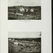
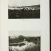
DP 112375
General oblique aerial view of Port Ellen Airport and Machrie Hotel with the golf course adjacent, taken from the SSW.
RCAHMS Aerial Photography Digital
3/5/2011
© Crown Copyright: HES

SC 2139373
Estate Exchange. Kildalton and Oa Esatates. no. 1484 Sales Brochure. Includes details of 4 different lots: Corraray (lot 4), Lower Cragabus (lot 2), Castlehill, Duich (lot 4), Kilbride (lot 3), Machrie (lot 3) etc. Map and text. Title: 'The Kildalton and Oa Estates, Argyllshire. The Property of Iain Ramsay Esq. J.P.'
Collection of sale catalogues relating to Scottish estates
25/6/1914
© Courtesy of HES (Estates Exchange Collection)

SC 2139381
Estate Exchange. Kildalton and Oa Esatates. no. 1484 Sales Brochure. Includes details of 4 different lots: Corraray (lot 4), Lower Cragabus (lot 2), Castlehill, Duich (lot 4), Kilbride (lot 3), Machrie (lot 3) etc. Map and text. Title: 'The Kildalton and Oa Estates, Argyllshire. The Property of Iain Ramsay Esq. J.P.'
Collection of sale catalogues relating to Scottish estates
25/6/1914
© Courtesy of HES (Estates Exchange Collection)

SC 2139384
Estate Exchange. Kildalton and Oa Esatates. no. 1484 Sales Brochure. Includes details of 4 different lots: Corraray (lot 4), Lower Cragabus (lot 2), Castlehill, Duich (lot 4), Kilbride (lot 3), Machrie (lot 3) etc. Map and text. Title: 'The Kildalton and Oa Estates, Argyllshire. The Property of Iain Ramsay Esq. J.P.'
Collection of sale catalogues relating to Scottish estates
25/6/1914
© Courtesy of HES (Estates Exchange Collection)

SC 2139386
Estate Exchange. Kildalton and Oa Esatates. no. 1484 Sales Brochure. Includes details of 4 different lots: Corraray (lot 4), Lower Cragabus (lot 2), Castlehill, Duich (lot 4), Kilbride (lot 3), Machrie (lot 3) etc. Map and text. Title: 'The Kildalton and Oa Estates, Argyllshire. The Property of Iain Ramsay Esq. J.P.'
Collection of sale catalogues relating to Scottish estates
25/6/1914
© Courtesy of HES (Estates Exchange Collection)

SC 2139391
Estate Exchange. Kildalton and Oa Esatates. no. 1484 Sales Brochure. Includes details of 4 different lots: Corraray (lot 4), Lower Cragabus (lot 2), Castlehill, Duich (lot 4), Kilbride (lot 3), Machrie (lot 3) etc. Map and text. Title: 'The Kildalton and Oa Estates, Argyllshire. The Property of Iain Ramsay Esq. J.P.'
Collection of sale catalogues relating to Scottish estates
25/6/1914
© Courtesy of HES (Estates Exchange Collection)

SC 2139398
Estate Exchange. Kildalton and Oa Esatates. no. 1484 Sales Brochure. Includes details of 4 different lots: Corraray (lot 4), Lower Cragabus (lot 2), Castlehill, Duich (lot 4), Kilbride (lot 3), Machrie (lot 3) etc. Map and text. Title: 'The Kildalton and Oa Estates, Argyllshire. The Property of Iain Ramsay Esq. J.P.'
Collection of sale catalogues relating to Scottish estates
25/6/1914
© Courtesy of HES (Estates Exchange Collection)

SC 2139409
Estate Exchange. Kildalton and Oa Esatates. no. 1484 Sales Brochure. Includes details of 4 different lots: Corraray (lot 4), Lower Cragabus (lot 2), Castlehill, Duich (lot 4), Kilbride (lot 3), Machrie (lot 3) etc. Map and text. Title: 'The Kildalton and Oa Estates, Argyllshire. The Property of Iain Ramsay Esq. J.P.'
Collection of sale catalogues relating to Scottish estates
25/6/1914
© Courtesy of HES (Estates Exchange Collection)

SC 2139450
Estate Exchange. Kildalton and Oa Esatates. no. 1484 Sales Brochure. Includes details of 4 different lots: Corraray (lot 4), Lower Cragabus (lot 2), Castlehill, Duich (lot 4), Kilbride (lot 3), Machrie (lot 3) etc. Map and text. Title: 'The Kildalton and Oa Estates, Argyllshire. The Property of Iain Ramsay Esq. J.P.'
Collection of sale catalogues relating to Scottish estates
25/6/1914
© Courtesy of HES (Estates Exchange Collection)

SC 2139379
Estate Exchange. Kildalton and Oa Esatates. no. 1484 Sales Brochure. Includes details of 4 different lots: Corraray (lot 4), Lower Cragabus (lot 2), Castlehill, Duich (lot 4), Kilbride (lot 3), Machrie (lot 3) etc. Map and text. Title: 'The Kildalton and Oa Estates, Argyllshire. The Property of Iain Ramsay Esq. J.P.'
Collection of sale catalogues relating to Scottish estates
25/6/1914
© Courtesy of HES (Estates Exchange Collection)

SC 2139382
Estate Exchange. Kildalton and Oa Esatates. no. 1484 Sales Brochure. Includes details of 4 different lots: Corraray (lot 4), Lower Cragabus (lot 2), Castlehill, Duich (lot 4), Kilbride (lot 3), Machrie (lot 3) etc. Map and text. Title: 'The Kildalton and Oa Estates, Argyllshire. The Property of Iain Ramsay Esq. J.P.'
Collection of sale catalogues relating to Scottish estates
25/6/1914
© Courtesy of HES (Estates Exchange Collection)

SC 2139388
Estate Exchange. Kildalton and Oa Esatates. no. 1484 Sales Brochure. Includes details of 4 different lots: Corraray (lot 4), Lower Cragabus (lot 2), Castlehill, Duich (lot 4), Kilbride (lot 3), Machrie (lot 3) etc. Map and text. Title: 'The Kildalton and Oa Estates, Argyllshire. The Property of Iain Ramsay Esq. J.P.'
Collection of sale catalogues relating to Scottish estates
25/6/1914
© Courtesy of HES (Estates Exchange Collection)

SC 2139390
Estate Exchange. Kildalton and Oa Esatates. no. 1484 Sales Brochure. Includes details of 4 different lots: Corraray (lot 4), Lower Cragabus (lot 2), Castlehill, Duich (lot 4), Kilbride (lot 3), Machrie (lot 3) etc. Map and text. Title: 'The Kildalton and Oa Estates, Argyllshire. The Property of Iain Ramsay Esq. J.P.'
Collection of sale catalogues relating to Scottish estates
25/6/1914
© Courtesy of HES (Estates Exchange Collection)

SC 2139411
Estate Exchange. Kildalton and Oa Esatates. no. 1484 Sales Brochure. Includes details of 4 different lots: Corraray (lot 4), Lower Cragabus (lot 2), Castlehill, Duich (lot 4), Kilbride (lot 3), Machrie (lot 3) etc. Map and text. Title: 'The Kildalton and Oa Estates, Argyllshire. The Property of Iain Ramsay Esq. J.P.'
Collection of sale catalogues relating to Scottish estates
25/6/1914
© Courtesy of HES (Estates Exchange Collection)

SC 2139412
Estate Exchange. Kildalton and Oa Esatates. no. 1484 Sales Brochure. Includes details of 4 different lots: Corraray (lot 4), Lower Cragabus (lot 2), Castlehill, Duich (lot 4), Kilbride (lot 3), Machrie (lot 3) etc. Map and text. Title: 'The Kildalton and Oa Estates, Argyllshire. The Property of Iain Ramsay Esq. J.P.'
Collection of sale catalogues relating to Scottish estates
25/6/1914
© Courtesy of HES (Estates Exchange Collection)

SC 2139414
Estate Exchange. Kildalton and Oa Esatates. no. 1484 Sales Brochure. Includes details of 4 different lots: Corraray (lot 4), Lower Cragabus (lot 2), Castlehill, Duich (lot 4), Kilbride (lot 3), Machrie (lot 3) etc. Map and text. Title: 'The Kildalton and Oa Estates, Argyllshire. The Property of Iain Ramsay Esq. J.P.'
Collection of sale catalogues relating to Scottish estates
25/6/1914
© Courtesy of HES (Estates Exchange Collection)

SC 2139430
Estate Exchange. Kildalton and Oa Esatates. no. 1484 Sales Brochure. Includes details of 4 different lots: Corraray (lot 4), Lower Cragabus (lot 2), Castlehill, Duich (lot 4), Kilbride (lot 3), Machrie (lot 3) etc. Map and text. Title: 'The Kildalton and Oa Estates, Argyllshire. The Property of Iain Ramsay Esq. J.P.'
Collection of sale catalogues relating to Scottish estates
25/6/1914
© Courtesy of HES (Estates Exchange Collection)

SC 2139432
Estate Exchange. Kildalton and Oa Esatates. no. 1484 Sales Brochure. Includes details of 4 different lots: Corraray (lot 4), Lower Cragabus (lot 2), Castlehill, Duich (lot 4), Kilbride (lot 3), Machrie (lot 3) etc. Map and text. Title: 'The Kildalton and Oa Estates, Argyllshire. The Property of Iain Ramsay Esq. J.P.'
Collection of sale catalogues relating to Scottish estates
25/6/1914
© Courtesy of HES (Estates Exchange Collection)

SC 2139434
Estate Exchange. Kildalton and Oa Esatates. no. 1484 Sales Brochure. Includes details of 4 different lots: Corraray (lot 4), Lower Cragabus (lot 2), Castlehill, Duich (lot 4), Kilbride (lot 3), Machrie (lot 3) etc. Map and text. Title: 'The Kildalton and Oa Estates, Argyllshire. The Property of Iain Ramsay Esq. J.P.'
Collection of sale catalogues relating to Scottish estates
25/6/1914
© Courtesy of HES (Estates Exchange Collection)

SC 2139449
Estate Exchange. Kildalton and Oa Esatates. no. 1484 Sales Brochure. Includes details of 4 different lots: Corraray (lot 4), Lower Cragabus (lot 2), Castlehill, Duich (lot 4), Kilbride (lot 3), Machrie (lot 3) etc. Map and text. Title: 'The Kildalton and Oa Estates, Argyllshire. The Property of Iain Ramsay Esq. J.P.'
Collection of sale catalogues relating to Scottish estates
25/6/1914
© Courtesy of HES (Estates Exchange Collection)

SC 2139374
Estate Exchange. Kildalton and Oa Esatates. no. 1484 Sales Brochure. Includes details of 4 different lots: Corraray (lot 4), Lower Cragabus (lot 2), Castlehill, Duich (lot 4), Kilbride (lot 3), Machrie (lot 3) etc. Map and text. Title: 'The Kildalton and Oa Estates, Argyllshire. The Property of Iain Ramsay Esq. J.P.'
Collection of sale catalogues relating to Scottish estates
25/6/1914
© Courtesy of HES (Estates Exchange Collection)

SC 2139378
Estate Exchange. Kildalton and Oa Esatates. no. 1484 Sales Brochure. Includes details of 4 different lots: Corraray (lot 4), Lower Cragabus (lot 2), Castlehill, Duich (lot 4), Kilbride (lot 3), Machrie (lot 3) etc. Map and text. Title: 'The Kildalton and Oa Estates, Argyllshire. The Property of Iain Ramsay Esq. J.P.'
Collection of sale catalogues relating to Scottish estates
25/6/1914
© Courtesy of HES (Estates Exchange Collection)

SC 2139393
Estate Exchange. Kildalton and Oa Esatates. no. 1484 Sales Brochure. Includes details of 4 different lots: Corraray (lot 4), Lower Cragabus (lot 2), Castlehill, Duich (lot 4), Kilbride (lot 3), Machrie (lot 3) etc. Map and text. Title: 'The Kildalton and Oa Estates, Argyllshire. The Property of Iain Ramsay Esq. J.P.'
Collection of sale catalogues relating to Scottish estates
25/6/1914
© Courtesy of HES (Estates Exchange Collection)

SC 2139417
Estate Exchange. Kildalton and Oa Esatates. no. 1484 Sales Brochure. Includes details of 4 different lots: Corraray (lot 4), Lower Cragabus (lot 2), Castlehill, Duich (lot 4), Kilbride (lot 3), Machrie (lot 3) etc. Map and text. Title: 'The Kildalton and Oa Estates, Argyllshire. The Property of Iain Ramsay Esq. J.P.'
Collection of sale catalogues relating to Scottish estates
25/6/1914
© Courtesy of HES (Estates Exchange Collection)

SC 2139426
Estate Exchange. Kildalton and Oa Esatates. no. 1484 Sales Brochure. Includes details of 4 different lots: Corraray (lot 4), Lower Cragabus (lot 2), Castlehill, Duich (lot 4), Kilbride (lot 3), Machrie (lot 3) etc. Map and text. Title: 'The Kildalton and Oa Estates, Argyllshire. The Property of Iain Ramsay Esq. J.P.'
Collection of sale catalogues relating to Scottish estates
25/6/1914
© Courtesy of HES (Estates Exchange Collection)

SC 2139433
Estate Exchange. Kildalton and Oa Esatates. no. 1484 Sales Brochure. Includes details of 4 different lots: Corraray (lot 4), Lower Cragabus (lot 2), Castlehill, Duich (lot 4), Kilbride (lot 3), Machrie (lot 3) etc. Map and text. Title: 'The Kildalton and Oa Estates, Argyllshire. The Property of Iain Ramsay Esq. J.P.'
Collection of sale catalogues relating to Scottish estates
25/6/1914
© Courtesy of HES (Estates Exchange Collection)

SC 2139440
Estate Exchange. Kildalton and Oa Esatates. no. 1484 Sales Brochure. Includes details of 4 different lots: Corraray (lot 4), Lower Cragabus (lot 2), Castlehill, Duich (lot 4), Kilbride (lot 3), Machrie (lot 3) etc. Map and text. Title: 'The Kildalton and Oa Estates, Argyllshire. The Property of Iain Ramsay Esq. J.P.'
Collection of sale catalogues relating to Scottish estates
25/6/1914
© Courtesy of HES (Estates Exchange Collection)

SC 2139441
Estate Exchange. Kildalton and Oa Esatates. no. 1484 Sales Brochure. Includes details of 4 different lots: Corraray (lot 4), Lower Cragabus (lot 2), Castlehill, Duich (lot 4), Kilbride (lot 3), Machrie (lot 3) etc. Map and text. Title: 'The Kildalton and Oa Estates, Argyllshire. The Property of Iain Ramsay Esq. J.P.'
Collection of sale catalogues relating to Scottish estates
25/6/1914
© Courtesy of HES (Estates Exchange Collection)

SC 2139442
Estate Exchange. Kildalton and Oa Esatates. no. 1484 Sales Brochure. Includes details of 4 different lots: Corraray (lot 4), Lower Cragabus (lot 2), Castlehill, Duich (lot 4), Kilbride (lot 3), Machrie (lot 3) etc. Map and text. Title: 'The Kildalton and Oa Estates, Argyllshire. The Property of Iain Ramsay Esq. J.P.'
Collection of sale catalogues relating to Scottish estates
25/6/1914
© Courtesy of HES (Estates Exchange Collection)

SC 2139443
Estate Exchange. Kildalton and Oa Esatates. no. 1484 Sales Brochure. Includes details of 4 different lots: Corraray (lot 4), Lower Cragabus (lot 2), Castlehill, Duich (lot 4), Kilbride (lot 3), Machrie (lot 3) etc. Map and text. Title: 'The Kildalton and Oa Estates, Argyllshire. The Property of Iain Ramsay Esq. J.P.'
Collection of sale catalogues relating to Scottish estates
25/6/1914
© Courtesy of HES (Estates Exchange Collection)

SC 2139445
Estate Exchange. Kildalton and Oa Esatates. no. 1484 Sales Brochure. Includes details of 4 different lots: Corraray (lot 4), Lower Cragabus (lot 2), Castlehill, Duich (lot 4), Kilbride (lot 3), Machrie (lot 3) etc. Map and text. Title: 'The Kildalton and Oa Estates, Argyllshire. The Property of Iain Ramsay Esq. J.P.'
Collection of sale catalogues relating to Scottish estates
25/6/1914
© Courtesy of HES (Estates Exchange Collection)

SC 2139448
Estate Exchange. Kildalton and Oa Esatates. no. 1484 Sales Brochure. Includes details of 4 different lots: Corraray (lot 4), Lower Cragabus (lot 2), Castlehill, Duich (lot 4), Kilbride (lot 3), Machrie (lot 3) etc. Map and text. Title: 'The Kildalton and Oa Estates, Argyllshire. The Property of Iain Ramsay Esq. J.P.'
Collection of sale catalogues relating to Scottish estates
25/6/1914
© Courtesy of HES (Estates Exchange Collection)

SC 2139451
Estate Exchange. Kildalton and Oa Esatates. no. 1484 Sales Brochure. Includes details of 4 different lots: Corraray (lot 4), Lower Cragabus (lot 2), Castlehill, Duich (lot 4), Kilbride (lot 3), Machrie (lot 3) etc. Map and text. Title: 'The Kildalton and Oa Estates, Argyllshire. The Property of Iain Ramsay Esq. J.P.'
Collection of sale catalogues relating to Scottish estates
25/6/1914
© Courtesy of HES (Estates Exchange Collection)

SC 2139387
Estate Exchange. Kildalton and Oa Esatates. no. 1484 Sales Brochure. Includes details of 4 different lots: Corraray (lot 4), Lower Cragabus (lot 2), Castlehill, Duich (lot 4), Kilbride (lot 3), Machrie (lot 3) etc. Map and text. Title: 'The Kildalton and Oa Estates, Argyllshire. The Property of Iain Ramsay Esq. J.P.'
Collection of sale catalogues relating to Scottish estates
25/6/1914
© Courtesy of HES (Estates Exchange Collection)

SC 2139395
Estate Exchange. Kildalton and Oa Esatates. no. 1484 Sales Brochure. Includes details of 4 different lots: Corraray (lot 4), Lower Cragabus (lot 2), Castlehill, Duich (lot 4), Kilbride (lot 3), Machrie (lot 3) etc. Map and text. Title: 'The Kildalton and Oa Estates, Argyllshire. The Property of Iain Ramsay Esq. J.P.'
Collection of sale catalogues relating to Scottish estates
25/6/1914
© Courtesy of HES (Estates Exchange Collection)

SC 2139403
Estate Exchange. Kildalton and Oa Esatates. no. 1484 Sales Brochure. Includes details of 4 different lots: Corraray (lot 4), Lower Cragabus (lot 2), Castlehill, Duich (lot 4), Kilbride (lot 3), Machrie (lot 3) etc. Map and text. Title: 'The Kildalton and Oa Estates, Argyllshire. The Property of Iain Ramsay Esq. J.P.'
Collection of sale catalogues relating to Scottish estates
25/6/1914
© Courtesy of HES (Estates Exchange Collection)

SC 2139404
Estate Exchange. Kildalton and Oa Esatates. no. 1484 Sales Brochure. Includes details of 4 different lots: Corraray (lot 4), Lower Cragabus (lot 2), Castlehill, Duich (lot 4), Kilbride (lot 3), Machrie (lot 3) etc. Map and text. Title: 'The Kildalton and Oa Estates, Argyllshire. The Property of Iain Ramsay Esq. J.P.'
Collection of sale catalogues relating to Scottish estates
25/6/1914
© Courtesy of HES (Estates Exchange Collection)

SC 2139418
Estate Exchange. Kildalton and Oa Esatates. no. 1484 Sales Brochure. Includes details of 4 different lots: Corraray (lot 4), Lower Cragabus (lot 2), Castlehill, Duich (lot 4), Kilbride (lot 3), Machrie (lot 3) etc. Map and text. Title: 'The Kildalton and Oa Estates, Argyllshire. The Property of Iain Ramsay Esq. J.P.'
Collection of sale catalogues relating to Scottish estates
25/6/1914
© Courtesy of HES (Estates Exchange Collection)

SC 2139422
Estate Exchange. Kildalton and Oa Esatates. no. 1484 Sales Brochure. Includes details of 4 different lots: Corraray (lot 4), Lower Cragabus (lot 2), Castlehill, Duich (lot 4), Kilbride (lot 3), Machrie (lot 3) etc. Map and text. Title: 'The Kildalton and Oa Estates, Argyllshire. The Property of Iain Ramsay Esq. J.P.'
Collection of sale catalogues relating to Scottish estates
25/6/1914
© Courtesy of HES (Estates Exchange Collection)

SC 2139429
Estate Exchange. Kildalton and Oa Esatates. no. 1484 Sales Brochure. Includes details of 4 different lots: Corraray (lot 4), Lower Cragabus (lot 2), Castlehill, Duich (lot 4), Kilbride (lot 3), Machrie (lot 3) etc. Map and text. Title: 'The Kildalton and Oa Estates, Argyllshire. The Property of Iain Ramsay Esq. J.P.'
Collection of sale catalogues relating to Scottish estates
25/6/1914
© Courtesy of HES (Estates Exchange Collection)

SC 2139437
Estate Exchange. Kildalton and Oa Esatates. no. 1484 Sales Brochure. Includes details of 4 different lots: Corraray (lot 4), Lower Cragabus (lot 2), Castlehill, Duich (lot 4), Kilbride (lot 3), Machrie (lot 3) etc. Map and text. Title: 'The Kildalton and Oa Estates, Argyllshire. The Property of Iain Ramsay Esq. J.P.'
Collection of sale catalogues relating to Scottish estates
25/6/1914
© Courtesy of HES (Estates Exchange Collection)


- Council Argyll And Bute
- Parish Kildalton And Oa
- Former Region Strathclyde
- Former District Argyll And Bute
- Former County Argyll
NR 3318 5171 A watching brief was completed on the topsoil stripping of three house plots totalling 369.5 m2, to the immediate south of Glenegedale House, Glenegedale, Isle of Islay. No significant archaeological features or artefacts were identified.
Information from Martin Cook (AOC Archaeology Group) 11 April 2007. Oasis ID: aocarcha1-26984.

