
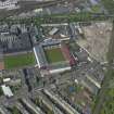
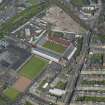
Edinburgh, Mcleod Street, Tynecastle High School


School (20th Century), Well (19th Century)
Site Name Edinburgh, Mcleod Street, Tynecastle High School
Classification School (20th Century), Well (19th Century)
Alternative Name(s) Tynecastle Supplementary School; Tynecastle Technical And Commercial School
Canmore ID 150696
Site Number NT27SW 2750
NGR NT 23171 72576
Datum OSGB36 - NGR
Permalink http://canmore.org.uk/site/150696


- Council Edinburgh, City Of
- Parish Edinburgh (Edinburgh, City Of)
- Former Region Lothian
- Former District City Of Edinburgh
- Former County Midlothian
NT27SW 2750.00 23171 72576
NT27SW 2750.01 23117 72660 Workshops
Architect: John Alexander Carfrae
John Alexander Carfrae, 1910-11, and later additions. Extensive L-plan Free Renaissance school with some Caroline detail; canted pedimented entrance across apex, with timber bellcote cupola, and further wing extending behind. Detached workshop ranges complete quadrangle. Numerous additions, including dining hall and gymnasium, within schoolyard.
Harled; dressings of cream or red ashlar, or red brick; gable and dormerheads with cream ashlar pediments. Red brick base course extends to ground floor cills. Cills to 1st floor windows. (Historic Environment Scotland List Entry)
Project (1997)
The Public Monuments and Sculpture Association (http://www.pmsa.org.uk/) set up a National Recording Project in 1997 with the aim of making a survey of public monuments and sculpture in Britain ranging from medieval monuments to the most contemporary works. Information from the Edinburgh project was added to the RCAHMS database in October 2010 and again in 2012.
The PMSA (Public Monuments and Sculpture Association) Edinburgh Sculpture Project has been supported by Eastern Photocolour, Edinburgh College of Art, the Edinburgh World Heritage Trust, Historic Scotland, the Hope Scott Trust, The Old Edinburgh Club, the Pilgrim Trust, the RCAHMS, and the Scottish Archive Network.
Field Visit (22 April 2006)
Within a roundel is a seated woman, holding a tablet or slate in her left hand whish she points to with her right hand. On her right stands a child with a book in his hand. By the woman's left foot is a globe.
The roundel is within an aedicule framing doors onto a balcony. To either side is a window, over which is a carved cornucopia.
Inspected By : Joan M Kennedy
Inscriptions : None
Signatures : None
Design period : 1910-1911
Information from Public Monuments and Sculpture Association (PMSA Work Ref : EDIN0433)
Ground Survey (4 October 2007 - 5 October 2007)
NT 231 725 This work was undertaken on 4-5 October 2007. The proposed development area is on the site of a current City of Edinburgh Council depot. The assessment and walkover were requested as the town plan of 1893/94 and Ordnance Survey map of 1896 both show a number of buildings across the site. These buildings are not shown on the OS map of 1908, when the City Road Stone Depot occupied the site. The project aimed to locate any traces of these buildings during the walkover survey as well as determining the form and function of
the current buildings prior to their demolition. A photographic survey was also undertaken in order to create a record of the site. The survey did not discover any trace of the 1890s buildings and only two of the existing buildings were found to date form the 1900s. The remainder of the buildings dated from the 1960s to the 1980s. The walkover survey was carried out on 4 October 2007 in sunny weather conditions.
Archive deposited with RCAHMS.
Funder: Laing O'Rourke (Scotland) Ltd.
Desk Based Assessment (4 October 2007 - 8 July 2008)
NT 231 725 (centred on) SUAT Ltd was commissioned by Laing O'Rourke (Scotland) Ltd to undertake a desk-based assessment and walkover survey of the proposed new site of Tynecastle High School, Edinburgh. The proposed development area is located on the site of a current City of Edinburgh Council depot. The assessment and walkover were requested as the town plan of 1893/94 and Ordance Survey map of 1896 both have a number of buildings located across the site. There buildings are not shown on the OS map of 1908 when the City Road Stone Depot is located on the site. The project aimed to determine whether any trace of these buildings could be located during the walkover survey as well as determining the form and function of the current buildings prior to their demolition. A photographic survey was also undertaken in order to create a record of the site.
The survey of the site did not actually discover any trace of remains for the 1890's buildings and only two of the existing buildings were found to date from the 1900's. The remainder of the buildings dated from the 1960's to the 1980's.
The walkover survey was carried out on the 4th October 2007 in sunny weather conditions. The SUAT site code for this project was EB15.
Kieran Haines (SUAT Ltd), 18 October 2007.
Watching Brief (12 February 2008 - 8 July 2008)
NT 231 725 (centred on) A watching brief was undertaken on a range of dates between 12 February–8 July 2008 during the construction of a school. It was hoped that any remaining traces of buildings, shown on the 1896 OS map, would be located during the monitoring of soil stripping. The work revealed that the ground had been heavily disturbed during the construction of the City Roads Stone Depot around 1900. Made ground, under the stone cassies, was found to be up to 1.8m deep, suggesting that the water table had been a problem during the construction of the depot. No traces of the buildings shown on the 1896 OS map were discovered. During the excavation of an old sewer, a trench wall collapsed, revealing a barrel well which was then excavated.
The well was found to have been constructed in the 19th century, with voussoir bricks jammed in between the
barrels and the cut for the well. Three barrels fitted with hazel hoops were recorded. The top one was probably
softwood and the two below were oak. The lower barrel was under the water table and could not be investigated fully. The well probably related to one of the buildings shown on the 1896 OS map and may have been used as a domestic water supply. The barrels may have come from a nearby distillery or a local brewery.
Archive: RCAHMS
Funder: Laing O’ Rourke (Scotland) Ltd
Tamlin Barton (SUAT Ltd), 2008
Archaeological Evaluation (4 September 2023 - 6 September 2023)
NT 23145 72600 (centred on) AOC Archaeology Group was commissioned to undertake an archaeological evaluation prior to the construction of a residential development, community facilities and landscaping at the former Tynecastle High School.
The archaeological evaluation undertaken did not uncover any archaeological remains.
Information from L. Teufel AOC Archaeology Group.
OASIS ID: aocarcha1-518916

