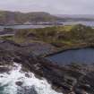
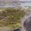
Accessibility

Font Size

100% 150% 200%

Background Colour

Default Contrast
Close Reset

Easdale, General

General View (Period Unassigned)

Site Name Easdale, General

Classification General View (Period Unassigned)

Alternative Name(s) Easdale Island

Canmore ID 150652

Site Number NM71NW 7

NGR NM 738 170

NGR Description Centred NM 738 170

Datum OSGB36 - NGR

Permalink http://canmore.org.uk/site/150652

Ordnance Survey licence number AC0000807262. All rights reserved.
Canmore Disclaimer. © Bluesky International Limited 2025. Public Sector Viewing Terms

Toggle Aerial | View on large map

Digital Images

Oblique aerial view of the island, centred on the remains of the quarries and the harbour, taken from the SE.
Oblique aerial view of the island, centred on the remains of the quarries and the harbour, taken from the SE.Oblique aerial view of the island, centred on the remains of the quarries and the harbour, taken from the E.Oblique aerial view from south east showing Klondyke Quarry (right) with An Lub Chlear and An Toll mar Luaty quarries beyond, Fang Quarry (left) and walled garden enclosures which pre-date the quarries in this area.Oblique aerial view from south Ellanabeich in background and Easdale Harbour, Village, East and Midd Engine Quarries and slate waste.Oblique aerial view showing East and Midd-Engine quarries, Village and HarbourOblique aerial view of An Toll Mar Luaty Quarry and later slate waste tipping as well as west coastal quarrying.Oblique aerial view of west end of island showing Windmill Quarry, north spoil, walls and workings  and the eroded slate waste tipping which have truncated enclosure walls and tipping runs from quarrying activityOblique aerial view of Klondyke QuarryOblique aerial view from south west of early north west coastal quarrying adjacent to Windmill and Hill Quarries.Scanned copy of GV008653. Map of south Easdale Island, Camus Mor area, showing HES survey of the south quarries including spoil, walls and workings.  Pencil survey drawing showing slate quarries, spoil and garden enclosures Oblique aerial view of the island, centred on the remains of the quarries and the harbour, taken from the ENE.Oblique aerial view of Easdale, looking NW.Oblique aerial view of Easdale, looking ESE.Oblique aerial viewOblique aerial view showing Village and HarbourOblique aerial view showing Windmill Quarry, Hill Quarry and North West Coastal Quarries from north east.Oblique aerial view of the west end of the islandOblique aerial view from west of south east part of islandEasdale Island.
General view of a cottage.Oblique aerial view of Easdale island, centred on the remains of the quarries and the harbour, taken from the SSE.Oblique aerial view of Easdale, looking NE.Oblique aerial view of Easdale, looking NNE.Oblique aerial viewOblique aerial view from north east.Oblique aerial view from north eastOblique aerial view of Fang and An Lub Chlear quarries and south west area of EasdaleOblique aerial view of west quarriesOblique aerial view from west of Windmill Quarry (left) and Hill Quarry (right) Oblique aerial view of Windmill, Hill Quarries and coastal quarryingOblique aerial view of Fang Quarry and landscapeScanned copy of GV008650. Map of Easdale Island showing HES phasing survey Oblique aerial view of Easdale and Ellenabeich, looking NNW.Oblique aerial view showing the garden enclosures overlying earlier slate waste and slate waste tippingOblique aerial view shwping Fang and An Lub Chlear quarries. A tramway (NM71NW 127.02) is also visible in the image (right foreground).Oblique aerial view showing East and Midd-Engine quarries and Easdale Village and Harbour.Oblique aerial view of south end Doune Quarry spoil from the north east. Oblique aerial view of Doune Quarry, post-1899 tramway with Windmill Quarry in the background.Oblique aerial view of north spoil, walls and workings from westOblique aerial view of west coastal coastal and deep quarryingOblique aerial view from south west of south west spoil, walls and workings landscape, Fang Quarry and An Lub Chlear Quarry, village and HarbourScanned copy of GV008648. Map of north-east corner of Easdale Island showing HES survey, including North spoil, walls and workings. Scanned copy of GV008651. Map of Easdale Island showing HES survey of quarries, tramways and slate distribution.Easdale Island.
General view of cottages.Easdale Island.
General view of two cottages.Oblique aerial viewOblique aerial view showing the quarries Fang, An lub chlear, An Toll mar Luaty and Klondyke (dry). These all post date 1871 and pre-date 1898.Oblique general  aerial view from north eastOblique aerial view of south coastal quarry area, extreme south west tip of EasdaleOblique aerial view south west area of EasdaleOblique aerial of south west corner of Easdale Island showing flooded quarries, garden enclosures (pre-1872) and a later post-1899 tramway (centred at NM73549 17046) cutting through the earlier enclosures.Oblique aerial viewOblique aerial view from north westOblique aerial view from west of area around waste tip/bing showing earlier quarrying in the area known as Camas Mor and the eastern edge of the south west spoil, walls and workingsOblique aerial view from west of Midd Engine and East Engine Quarries, Easdale village, central spoil, walls and workings and HarbourEasdale Island.
General view of a cottage.Easdale Island.
General view of two cottages.Oblique aerial view of Easdale, looking E.Oblique aerial view Oblique aerial view showing Klondyke Quarry with An Lub Chlear and An Toll mar Luaty quarries beyond from eastOblique aerial view showing Village and Harbour and East and Midd- engine quarriesOblique aerial view from north east showing north spoil, walls and workings, central spoil, walls and workings, Windmill, Doune and Hill Quarries.Oblique aerial view of east end of Easdale showing Doune Quarry (foreground), Hill Quarry (right), An Toll Mar Luaty Quarry with later slate waste dumped into it, An Dub Chlear Quarry, and Fang Quarry (top left)Oblique aerial view of East (right) and Midd Engine Quarries from north east. Note also the shoreline quarrying and proximity of the original village and the garden enclosures on the left on the quarry edgeOblique aerial view from southOblique aerial view from south westOblique aerial view of south side of islandScan of pencil survey drawing showing slate quarries, spoil and garden enclosures Oblique aerial view of Easdale, looking NE.Oblique aerial view of Easdale, looking N.Oblique aerial view of Easdale and Ellenabeich, looking NNW.Oblique aerial viewOblique aerial view showing Windmill (flooded, right) and Hill Quarry (FLOODED, LEFT), west end of Doune Quarry (left) and the 'fingers' of the tipping (foreground) from the reworking of Hill Quarry in the early 20th century.Oblique aerial view showing Klondyke Quarry with An Lub Chlear and An Toll mar Luaty quarries beyond from eastOblique aerial view from south east showing Midd and East Engine Quarries, (right), shoreline working, Easdale Village and Harbour.Oblique aerial view east edge of Hill Quarry and tramways which linked Windmill and Hill Quarries to the Harbour and linked to the western quarries An Toll Mar Luarty, An Lub Chlear and Fang.Oblique aerial view of south west spoil, walls and workings and tramway (post-1899)Oblique aerial view of west end of island showing Windmill and Hill Quarries (nearest the camera)Oblique aerial view of west end of island from west.Easdale Island.
General view of a cottage.General distant oblique aerial view centred on the village and the remains of the slate quarries with the slate quarry and harbour adjacent, taken from the ESE.Oblique aerial view of Easdale, looking NW.Oblique aerial view from east showing East and Midd-Engine quarries and south east spoil, walls and workings.Oblique aerial view from north east.Oblique aerial view from west showing original tramway, post-1899 tramway, and the landscape towards the Village.Oblique aerial view from north west with Windmill and Hill Quarries in foregroundScanned copy of GV008644. Map of Easdale Island showing the mapping and phasing of the HES survey, quarrying activity, tipping, internal transport and garden enclosures. Easdale Island.
General view of cottages.

Administrative Areas

  • Council Argyll And Bute
  • Parish Kilbrandon And Kilchattan
  • Former Region Strathclyde
  • Former District Argyll And Bute
  • Former County Argyll

Activities

Note (25 February 2019)

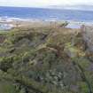
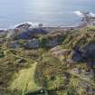
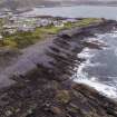
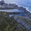
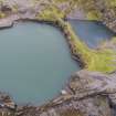
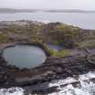
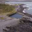
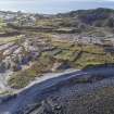
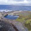
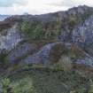
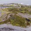
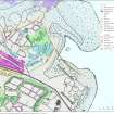
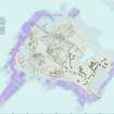
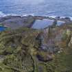
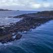
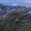
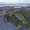
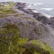
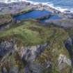
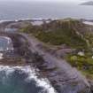
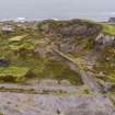
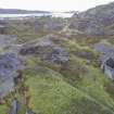
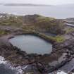
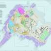
A field survey was carried out of the west, north and east and south east portions of Easdale Island by Historic Environment Scotland (HES) on visits over the period 2015-2017. This is complex and ever changing quarried landscape.

See also:

NM71NW 2.00 EASDALE, INDUSTRIAL LANDSCAPE

NM71NW 2.01 EASDALE, SLATE LOADING JETTY, BREAKWATER

NM71NW 2.02 EASDALE, NORTH JETTY, SLATE SLABS

NM71NW 4 EASDALE, EASDALE HARBOUR

NM71NW 7 EASDALE, GENERAL

NM71NW 17 EASDALE, THE DRILL HALL

NM71NW 106 EASDALE, EILEAN AN UAN, Engine House

NM71NW 112 EASDALE, EAST QUARRY 1

NM71NW 113 EASDALE, EAST QUARRY 2

NM71NW 114 EASDALE, QUARRY ('Windmill Quarry')

NM71NW 115.00 EASDALE, QUARRY ('Hill Quarry')

NM71NW 115.01 EASDALE, QUARRY ('Hill Quarry'), STONE WORKING SITE

NM71NW 116 EASDALE, QUARRY

NM71NW 117 EASDALE, QUARRY

NM71NW 118.00 EASDALE, QUARRY

NM71NW 118.01 EASDALE, STRUCTURE

NM71NW 118.02 EASDALE, STRUCTURE

NM71NW 118.03 EASDALE, QUARRY RETAINING WALL

NM71NW 119 EASDALE, QUARRY

NM71NW 120 EASDALE, QUARRY ('Klondyke Quarry')

NM71NW 121 EASDALE, QUARRY

NM71NW 122 EASDALE, REMODELLED JETTIES

NM71NW 123 EASDALE, NORTH SPOIL, WALLS AND WORKINGS

NM71NW 124 EASDALE, CENTRAL SPOIL, WALLS AND WORKINGS

NM71NW 125 EASDALE, SOUTH WESTSPOIL, WALLS AND WORKINGS

NM71NW 126 EASDALE, SOUTH EAST SPOIL, WALLS AND WORKINGS

NM71NW 127 EASDALE, TRAMWAY ROUTES

NM71NW 128 EASDALE, QUARRY

NM71NW 129 EASDALE, QUARRY

NM71NW 130 EASDALE, COAL STORE/FORMER LOCOMOTIVE SHED

NM71NW 131.00 EASDALE, ENGINE HOUSE

NM71NW 131.01 EASDALE, POWDER MAGAZINE

NM71NW 132 EASDALE, INDUSTRIAL BUILDING

NM71NW 133 EASDALE, INDUSTRIAL BUILDING

NM71NW 134 EASDALE, CISTERN

NM71NW 135 EASDALE, GARDEN ENCLOSURE

NM71NW 136 EASDALE, POWDER MAGAZINE

NM71NW 141 EASDALE, BOILER HOUSE

NM71NW 142 EASDALE, MACHINERY PLINTH

NM71NW 143 EASDALE, PUMP HOUSE

NM71NW 144 EASDALE, BUILDING

NM71NW 145 EASDALE, EAST QUARRY 1, STRUCTURE

NM71NW 146 EASDALE, VOLUNTEER ARTILLERY BATTERY

NM71NW 147 EASDALE, NORTH EAST SPOIL, WALLS AND WORKINGS

Information from Survey and Recording Section, Heritage Directorate, HES, 25 February 2019.

References

MyCanmore Image Contributions


Contribute an Image

MyCanmore Text Contributions