
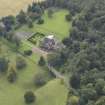
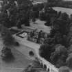
Oxenfoord Castle, Viaduct


Road Bridge (18th Century), Viaduct (18th Century)
Site Name Oxenfoord Castle, Viaduct
Classification Road Bridge (18th Century), Viaduct (18th Century)
Alternative Name(s) Oxenford Bridge
Canmore ID 150379
Site Number NT36NE 62.03
NGR NT 38822 65580
Datum OSGB36 - NGR
Permalink http://canmore.org.uk/site/150379


- Council Midlothian
- Parish Cranston
- Former Region Lothian
- Former District Midlothian
- Former County Midlothian
NT36NE 62.03 38822 65580
NMRS REFERENCE:
Architect: Alexander Stevens 1783 - design for a new bridge

