
Pricing Change
New pricing for orders of material from this site will come into place shortly. Charges for supply of digital images, digitisation on demand, prints and licensing will be altered.
Upper Cullernie


Ring Ditch (Period Unassigned)(Possible)
Site Name Upper Cullernie
Classification Ring Ditch (Period Unassigned)(Possible)
Canmore ID 150368
Site Number NH74NW 115
NGR NH 7332 4818
Datum OSGB36 - NGR
Permalink http://canmore.org.uk/site/150368


- Council Highland
- Parish Petty
- Former Region Highland
- Former District Inverness
- Former County Inverness-shire
NH74NW 115 7332 4818
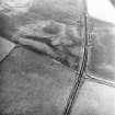
The cropmark of a possible ring-ditch, measuring about 20m in diameter within a broad ditch, has been revealed by oblique aerial photography (RCAHMSAP 1995) 650m N of Upper Cullernie farmsteading. A centrally placed mark, possibly a pit, suggests that this could be the cropmark of a barrow.
Information from RCAHMS (KJ) 14 October 1999.

